Reading...
![]()
Play button
![]()
Play button
![]()
Use LEFT and RIGHT arrow keys to navigate between flashcards;
Use UP and DOWN arrow keys to flip the card;
H to show hint;
A reads text to speech;
52 Cards in this Set
- Front
- Back
|
What types of land use maps are included in a comprehensive plan?
|
CURRENT land use map of existing conditions (zoning) and a FUTURE land use map (master plan) showing desired change.
|
|
|
What is a Land Classification Map?
|
A map that divides a planning jurisdiction into different classes of land (ie zoning map)
|
|
|
What is GIS?
|
Geographic information Systems-program used to prepare maps (in layers) and to prepare geogrpahical analysis of conditions.
|
|
|
What is an orthophoto map?
|
An aerial photo that has been rectified and can be used oto measure distance (ie USGS maps).
|
|
|
What is the difference between an aerial photograph and an orthophoto?
|
1.A conventional perspective aerial photograph contains image displacements caused by the tilting of the camera and terrain relief (topography). It does not have a uniform scale. You cannot measure distances on an aerial photograph like you can on a map. It is not a map. 2.The effects of tilt and relief are removed from the aerial photograph by the rectification process to create an orthophoto. 3.An orthophoto is a uniform-scale photograph. It is a photographic map. 4.Since an orthophoto has a uniform scale, it is possible to measure directly on it like other maps. 5.An orthophoto may serve as a base map onto which other map information may be overlaid.
|
|
|
What is a soils map and who are they made by?
|
A map that shows soil classifications and they are made by NRCS-National Resources Conservation Service
|
|
|
What is a flood map and who makes them?
|
A flood insurance rate map aka flood map shows land that has a 1% + chance of flooding in any given year. FEMA makes these maps.
|
|
|
1 Hectare
|
10,000 square meters=2.471 acres
|
|
|
1 Kilometer
|
1,000 meters= 3,281 feet
|
|
|
1 Square mile
|
640 acres
|
|
|
What is Floor Area Ratio?
|
aka FAR-the ratio of floor area of a building to teh size of teh lot
|
|
|
What does FAR=1 mean?
|
A 1 story building covers 100% of the lot or a 2 story building covers 50% of the lot
|
|
|
Density
|
# of dwelling units per acre
|
|
|
First Zoning Ordinance
|
New York City, 1916 drafted by Ernie Bassett
|
|
|
What is an urban growth barrier?
|
An urban growth boundary, or UGB, is a line drawn to separate urban areas from rural areas. It is used to control urban sprawl by mandating that the area inside the boundary be used for higher density (urban) development and the area outside be used for lower density (rural) development. Public infrastructure is NOT extended beyond UGB. Oregon Land Use Act 1973 created the first UGB's which was enough land to to support development for 20 years
|
|
|
Where was first urban growth barrier instituted?
|
Lexington and Fayette County, Kentucky
|
|
|
"The Father of American Zoning"
|
Attorney Edward Murray Bassett (1863–1948, age 84–85) was one of the founding fathers of modern day urban planning. Bassett wrote the first comprehensive zoning ordinance in the United States, adopted by New York City in 1916.
|
|
|
Zoning Premise
|
Incompatible land uses shold be separated
|
|
|
Book-Regional Survey of New york and Its Environs
|
Published 1928
Important because it viewed land use as a function of accessibility |
|
|
What is the Oregon Land Use Act, 1973
|
A statewide comprehensive land use management program to protect farmland. state mandated, locally implemented through urban growth boundary designations and exclusive farm use zoning.
|
|
|
Zoning definition
|
Police power (government right) to impose regulations to protect the public health, safety and welfare.
|
|
|
Large lot zoning
|
pros-reduces density
cons-contribute to sprawl and exludes low to moderate income households |
|
|
What are three sections of the AICP CODE OF ETHICS AND PROFESSIONAL CONDUCT
|
A= Aspirational Principles
C=Conduct (Rule of) P=Procedural Provisions (of the Code) |
|
|
What is a density bonus?
|
An increase in FAR in exchange for amenities
|
|
|
Where was the first zoning ordinance adopted? Who drafted it?
|
New York City (1916) drafted by Attorney Edward Bassett.
|
|
|
Where was the first urban growth boundary?
|
Lafayette County, Kentucky, 1958
|
|
|
Why is The Regional Survey of New York and Its Environs (1928) publication significant?
|
Clarence Perry's monograph on the Neighborhood Unit is published in Volume VII of it. Viewed land use as a function of accessibility. Landmark Publication Planned Communities
|
|
|
Why is the Oregon Land Use Act significant?
|
In 1973, Oregon adopted a statewide comprehensive land use management program. It provides statewide standards for farmland protection through state mandated, locally implemented urban growth boundary designations and exclusive farm use zoning.
|
|
|
What is zoning?
|
Police Power (government's right) to regulate land use to protect the public health, safety and convenience.
|
|
|
What is a zoning ordinance?
|
A legal document used to divide the community, regulate land use and intensity. Has both a map and text.
|
|
|
What is Euclidean zoning?
|
Based on court case Village of Euclid vs. Ambler Realty Company defends government's right to use zoning. Specifies separate use for each district and intensity. Does not allow for mixed use. This kind of zoning blamed fro sprawl because large areas are devoted to a single use.
|
|
|
Top three facts about Alfred Bettman
|
developed a comprehensive plan for Cincinnati, (first city to do so)
Successfully defended zoning in US Supreme Court in Euclid v Ambler Served as the first president of American Society of Planning Officials |
|
|
What is cumulative zoning?
|
*tiered, older approach to regulating land uses (zoning)
*less intensive uses allowed in more intensive areas |
|
|
What is non-cumulative zoning?
|
Zoning that allows only the listed land use.
|
|
|
What is form-based zoning?
|
*Regulates the size, form, appearance and placement of buildings and parking; NOT the land use and density
*Supports mixed-use neighborhoods with a range of housing types |
|
|
What is transect zoning?
|
*Describes zoning as a continuum of six zones from rural to urban districts
*Identifes different 3 dimensional development standards for the hierarchy of uses *a "new urbanism" tool to foster sustainability by decreasing need for long distnace travel * developed by Andres Duany |
|
|
What is performance zoning?
|
*Focuses on the intensity of development that is acceptable relative to its impact on the environment
*Focuses on how development impacts surrounding area |
|
|
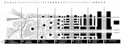
What does transect zoning look like?
|
|
|
|
What are the six zones of transect planning?
|
Rural preserve (protected areas in perpetuity); and Rural reserve (areas of high environmental or scenic quality that are not currently preserved, but perhaps should be).The transition zone between countryside and town is called the Edge, which encompasses the most rural part of the neighborhood, and the countryside just beyond. The Edge is primarily single family homes. Although Edge is the most purely residential zone, it can have some mixed-use, such as civic buildings (schools are particularly appropriate for the Edge). Next is General, the largest zone in most neighborhoods. General is primarily residential, but more urban in character (somewhat higher density with a mix of housing types and a slightly greater mix of uses allowed). At the urban end of the spectrum are two zones which are primarily mixed use: Center (this can be a small neighborhood center or a larger town center, the latter serving more than one neighborhood); and Core (serving the region — typically a central business district). Core is the most urban zone.[1]
|
|
|
What are subdivision regulations?
|
Used to divide land into two or more parcels and regulate the location and design of supporting infrastructure
|
|
|
What is rezoning?
|
A change from one zoning classification to another.
Tool to modify development regulations |
|
|
What is upzoning?
|
A rezone to allow a higher density development.
Tool to modify development regulations. |
|
|
What is downzoning?
|
A rezone to allow a lesser intensity development or moving down the euclidian zoning hiearchy from single family to multi family for example
Tools to modify development regulations |
|
|
What is a conditional use (aka exception or special use)?
|
A use not at allowed by right requiring a a public hearing to approve and a Conditional Use Permit. CUP states specific standards that applicant must meet.
Used to modify development regulations |
|
|
What is a variance?
|
A departure from the zoning ordinance which permits uses or relaxation of standards if strict application of the Code would cause and undue hardship to the owner.
Used to modify development regulations |
|
|
What is extraterritorial jurisdiction (aka ETJ)?
|
Authority granted by a state to a city to regulate zoning beyond its boundaries. Used to ensure development outside boundaries is compatible with development within boundaries.
Used to modify development regulations |
|
|
What must growth management approach to regulating development include?
|
Transportation analysis. Transportation and land use are closely linked.
Tool to regulate development |
|
|
What is an "Adequate Public Facilities Ordinance" (aka Concurrency Regulations)?
|
Synchronizes development with the availability of public facilities needed to support development such as parks, roads, schools, water & sewage
Tool to regulate development Tool to regulate development |
|
|
What are Transfer Development Rights?
|
Developer in urban area receiving area purchase rights to develop land in a rural sending area
has to be permitted by a zoning ordinance must include market share analysis to ensure that market exists for intensive development in the receiving area |
|
|
Explain TDR's
|
Transfer of development rights allow property owners to buy and sell development rights without actually exchanging any land. The basic TDR concept is to compensate landowners who give up potential development rights in environmentally sensitive areas or preservation districts. The goal is to direct development away from sensitive lands, known as "sending" areas, toward more suitable areas, called "receiving" areas.
|
|
|
Explain "Purchase of Development Rights".
|
City/agency buys a private landowners right to develop property.
Allows certain natural features of the land to be preserved. Landowner can still use it for farming or open space purposes. |
|
|
Explain "floating zone"
|
defines a use that the community wants that is not assigned to a particular parcel When in effect the floating zone regulations are in effect.
|