![]()
![]()
![]()
Use LEFT and RIGHT arrow keys to navigate between flashcards;
Use UP and DOWN arrow keys to flip the card;
H to show hint;
A reads text to speech;
150 Cards in this Set
- Front
- Back
- 3rd side (hint)
|
Abel Tasman |
First European, 1642 Surveyed West Coast, Vessel: HEMSKERK |
|
|
|
James Cook, RN |
HMS ENDEAVOUR First accurate surveys used until 1990's 2nd voyage - RESOLUTION in company with ADVENTURE |
|
|
|
Kauri Trees |
1800's surveys rare - Napoleonic Wars (battle of Trafalgar) SPAR supply - Baltic supply stopped - French controlled - USA supply stopped - American Revolution Ships travel VIA Australia - drop convicts- collect trees and survey before going home |
|
|
|
DRUMEDARY |
Ship used to drop off convicts and survey land /collect Kauri |
|
|
|
HMS BUFFALO |
ship used to drop off convicts and survey land/ collect Kauri, Wrecked in Whitianga 1840 - Military Survey Group Surveyed |
|
|
|
NZ Warships Stationed (HMS) |
PELORUS, HERALD, BRITOMART, DAPHNE, ALLIGATOR, VOYAGE, OSPREY. |
7 ships |
|
|
HMS OSPREY |
Lost on false Hokianga Bar |
|
|
|
CAPT D'Urville |
French COQUILLE - renamed ASTROLABE -largest NZ survey work since Cook , - used until 1990's - Discovered French Pass |
|
|
|
1848-1855 |
The Great Survey of NZ HMS ACHERON, CAPT Stokes HMS PANDORA , CAPT Drury Continued until 1905 with HMS PENGUINE and help from the TERA NOVA |
|
|
|
HMS VERONICA |
Surveyed in the 1920's Alongside for Napier Earthquake |
|
|
|
HMS ENDEAVOUR |
Last Royal Navy Survey vessel 1937 - WW2 |
|
|
|
HMAS ELAINE |
Surveyed Queen Charlotte Sound in 1942 |
|
|
|
1949 |
NZ Hydrographic Office Formed |
|
|
|
HMNZS LACHLAN |
Commissioned 1949- 1975, Australian River Classed frigate leased to NZ, Royal Navy Survey Officers and Ratings on loan. |
|
|
|
Survey Vessels |
HMNZS Lachlan, 1949- 1978 HMNZS TAKAPU &HMNZS TARAPUNGA, (Patrol Crafts) 1950's (Inshore Patrol Crafts) 1980-1981 HMNZS RESOLUTION, 1998-2012 SMB ADVENTURE, 2000 SMS DIRK, com/decom in 1 year REA BOATS, TAKAPU (A07) TAKAPUNGA (A08) Built 2013 HMNZS MANAWANUI, 2019 |
8 vessel groups |
|
|
HMNZS LACHLAN (ship details) |
1949-1975, Australian River Classed Frigate |
|
|
|
HMNZS MONOWAI |
1977, Originally Moana Roa, -Converted Merchant Vessel |
|
|
|
HMNZS TAKAPU & HMMZS TARAPUNGA (Patrol) |
1950's Patrol crafts fitted for survey duties. Replaced by inshore patrol crafts. |
|
|
|
HMNZS TAKAPU & HMMZS TARAPUNGA (Inshore Patrol) |
1980-1981 Replaced the patrol vessels |
|
|
|
HMNZS RESOLUTION |
1998-2012 Replaced HMNZS MONOWAI, Converted merchant vessel USNS TENACIOUS. |
|
|
|
SMB ADVENTURE |
2000 Replaced HMNZS TARAPUNGA &TAKAPU |
|
|
|
SMS DIRK |
Commissioned/Decommissioned in 1 year |
|
|
|
REA BOATS |
Built 2013, Takapu (A07), Tarapunga (A08) |
|
|
|
HMNZS MANAWANUI |
Commissioned 2019, Built 2003. Converted DP2, IMR Survey & light construction vessel (EDDA FONN) System Upgraded 2013 |
|
|
|
LINZ |
Land Information New Zealand ESTD. 1995 |
|
|
|
IHO |
International Hydrographics Organisation, ESTD. 1921 |
|
|
|
Hydrography RNZN |
Operating since 5 Oct 1949, 1995, sole responsibility removed by GOVT. Two departments, - GNZ, -Hydrography Trade |
|
|
|
GNZ |
Geospatial Intelligence New Zealand Duties, - printing charts for the RNZN, -Cartographers - GIS Specialists -Electronic Charting conversions Run by: LT COl. D. Taylor |
|
|
|
HOTN |
Hydrographer of the Navy - link between LINZ and the RNZN - Head of trade & posting adviser for trade officers - CDR T. GARVIN |
|
|
|
HTA |
Hydrographics Trade Advisor, - WOHLM N. TAMIHANA |
|
|
|
CMO |
Career Management Officer, - WOHST Karin Foster |
|
|
|
ACMO 1 |
Assistant Career Management Officer 1, -CPO EWS O'Brien |
|
|
|
ACMO 2 |
Assistant Career Management Officer 2, - CPO CSS D. ANDERSON |
|
|
|
ACMO 3 |
Assistant Career Management Officer 3, - CPO SCS LATU |
|
|
|
HSO Posting |
- NAV YEO - Ships Diver - University Scheme (VESA) - Anzac Exchange -Longlook -IHO CAT B - SRL (Skipper Restricted Limits) / Boat Masters Level 4 -NZ Certificate in Hydrography surveying Level 4 - Instructing Qualifications - Peacekeeping, eg. Afghanastan -Military Hydrographic group |
|
|
|
IHO |
International Hydrographic Organisation |
|
|
|
IMO |
International Maritime Organisation |
|
|
|
LINZ |
Land Information New Zealand |
|
|
|
MNZ |
Maritime New Zealand |
|
|
|
GNZ |
Geospatial Intelligence New Zealand |
|
|
|
DGNZ |
Director of Geospatial intelligence new Zealand |
|
|
|
MHG |
Military Hydrographics Group |
|
|
|
HTA |
Hydrographic Trade Adviser |
|
|
|
OPSO |
Operations Officer |
|
|
|
NO |
Navigating Officer |
|
|
|
SR |
Senior Survey Rating PO and above |
|
|
|
JR |
Junior Survey Rating 2 Star |
|
|
|
CAT A |
IHO qualification |
|
|
|
CAT B |
IHO Qualification |
|
|
|
SMB |
Survey Motor Boat |
|
|
|
POHST |
Petty Officer Hydrographics Survey Technitian |
|
|
|
GMT |
Greenwich Mean Time |
|
|
|
UTC |
Universal time Co Ordinate |
|
|
|
JD |
Julian Date |
|
|
|
BR |
Book of reference |
|
|
|
NP |
Nautical Publication |
|
|
|
HHOS |
Hydrographics Head of School |
|
|
|
Definition of hydrography |
The science of the measurement, description and mapping water of the earth, with special reference to their use for navigation. |
|
|
|
What is hydrographic surveying |
The collection of data of an area of sea and surrounding coastal detail to enable the cartographer to portray a part of the earths surface on a flat piece of paper and indicate by soundings, height and depth contours and spot heights the various irregularities both above and below the sea surface. |
|
|
|
P.O.S.S.D |
Position Orientation Scale Shape Detail |
|
|
|
Position |
At least 1 position must be known on the earth's surface to locate the survey, Found by - previous survey info - newly established by astronomical or satellite observations All collected positions are relative to this |
|
|
|
Orientation |
-Direction and Azimuth must be known - One position to another must be known -Direction between two points must be known or with 1 known position the sun can be used to observe for direction. |
|
|
|
Scale |
Distance between a minimum of two positions. - Direct measurement -By calculation with 2 known positions, known distance is the baseline and all others are relative. |
|
|
|
Shape |
Once Azimouth and scale is determined additional positions are coordinated to provide framework or detail |
|
|
|
Detail |
- Regular Depth seaward to shoreline - obtain and position least depth over shoals -coastline, HW,LW positions -nature of seabed - position of breakers/ tide tips ect - leading lights - Topographic details - tidal observations - tidal stream measurements - views - nav mark positions - sailing directions - wreck details - port information - - |
|
|
|
Hydrographic instructions |
(HI) -Used before LINZ establishment -issued by the hydrographic office/ hydrographer of New Zealand -HI's were replaced by a LINZ contract system |
|
|
|
LINZ Contracts |
Replaced Hydrographic Instructions when LINZ was established in 1995. |
|
|
|
HI or Contract format (A-M) |
- Introduction - limits of surveyed area - scale of conducted survey - the horizontal control - The vertical control- benchmark info - Sounding requirements - use of side scan sonar - Tidal data - Tidal stream Requirements - mischellaneous information -time frame/start/completion/Rendering - financial output code, cast centre, financial responsibility - Rendered data format Tidal data, coastline data, previous survey dates
|
|
|
|
Planning of surveys |
- Reconnaissance - Equipment - Accommodation - food ect |
4 things |
|
|
Who Carry's out Reconnaissance |
Carried out by a Senior Surveyor/Charge Surveyor |
|
|
|
Reconnaissance Phases |
Office phase and field phase |
|
|
|
Office phase |
Reconnaissance phase, Gathering required data ie. Topographic maps, Aerial photographs and geodetic stations in the area |
|
|
|
Field phase |
Reconnaissance phase Visiting the area, finding spots for tidal or positioning sites |
|
|
|
Established Reconissance Tasks |
- Tidal sites - Geodetic sites (known position points) - Accommodation for shore party - landing sites for RHIB - Establishing local relationships |
|
|
|
HI/ CONTRACT Storage (not the list) |
Record folders and file management systems created |
|
|
|
Managing an HI service area (breaking it up) |
- Area divided into blocks - Sounding line sets are created - Cross-lines sets are created - Routes to be used - Tidal files - Create seabed sample positions - Define calibration areas |
|
|
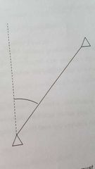
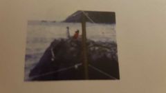
What is this |
How to Orientate a survey requirement |
|
|
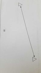
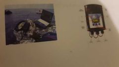
What is this showing |
Demonstrating scale for survey requirements |
|
|
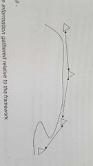
What does this show |
Demonstrates survey requirements for shape |
|
|
|
Hydrographic data storage folders |
QA Data pack Geodetic Data pack Oceanographic folder Online records Tidal data pack Offline records Data management records |
There are 7 of them |
|
|
Hydrographic Data management |
Additional computer is used 2 systems - data processing system - data storage system |
|
|
|
What goes in the Report of survey |
Final report of the completed survey All digital data collected LINZ report Sheets of sounding data Report comprises of 2 parts - part1 - Narrative - Part 2 - annex section
|
|
|
|
Survey report part 1- Narrative |
Brief description of survey narrative with the information gathered and how it was gathered. |
|
|
|
Survey report Part 2 - Annex section |
All of the part 1 (narrative) but covered in more detail eg. Equipment spec, accuracies achieved, seabed samples obtained ect. |
|
|
|
Who checks LINZ survey reports |
Charge Surveyor |
|
|
|
Pre-Survey (Plan) order of events |
○ Hydrographic instruction Received ○ Planning Chart constructed, system initialized ○ Reconnaissance of survey area ○ Stores uplifted ○ Calibrate and check gear ○Tidal stations & Geodetic stations established.
|
6 steps |
|
|
Pre-Survey (Do) |
○Ship arrives in survey area ○Ships survey systems calibrated ○Sounding datum established ○Sounding data collection commences ○Sounding data checked ○All field equipment recovered |
6 steps |
|
|
Post survey (write the report) |
○ Write the report ○ Records collated, survey report completed ○ Hydrographer checks completed survey. ○ LINZ checks and validates survey. ○ Survey changes accepted or returned. ○ survey data used to check or revise a chart. |
6 steps |
|
|
Biggest Kauri tree in NZ |
Tane Mahuta |
|
|
|
Field records |
Need to be clean and clear and not regarded as rough. |
|
|
|
Principles of recording |
- completeness of information - intelligible layout - carefully checked - neatness and legibility - honestey and accuracy |
|
|
|
What dictates a complete record of information. |
-Title -Ships name -HI/Contract number -Type of instrument & Serial Number -Names of observers and recorders -Dates and times of observations -Diagrams or Sketches of routes taken or structures -Metrological conditions -Dimensions of targets and structures -Correct Nomenclature (local and correct name) - Any difficulties or unusual circumstances that occurred - |
|
|
|
What initiates good recording |
-Collect and record all information before observations start - HB Pencil - never erase or overwrite a mistake, - notes and figures printed - all recordings made as though it is a fair copy - second copy (if required) should be checked by another person and initialed correct. - all recording checked, approved and initialed by research observer |
|
|
|
Post survey Record checking, how to |
-All records and Data must be free of errors and ambiguity - Checked by an independent person (higher rank prefered) - If in doubt tell someone - your name, your reputation |
|
|
|
Ensuring observations are recorded accurately |
-Observer calls out reading -recorder writes it down -recorder reads back observation - Observer confirms reading -Recorder calculates reading -Recorder tells observer good or 'check' |
|
|
|
Greenwich mean time established |
1675 |
|
|
|
1st time zone established by British railways |
Dec 1st, 1847 |
|
|
|
What time zone is used when surveying |
GMT or UTC |
|
|
|
How do you write 1425 on 3rd Feb ? (Zulu) |
031425ZFeb |
|
|
|
What is the Julian date |
Each calendar date is assigned a consecutive number between 1 and 365 or 366(leap year) starting Jan 1st |
|
|
|
What date do you add 1 to the julian date for a leap year |
March 1st |
|
|
|
What is a sounding sextant? |
Measures horizontal and vertical angles to the nearest minute. |
|
|
|
Levels |
Determining the difference in height between 2 or more points, accurate within 2mm |
|
|
|
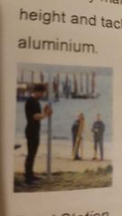
Tachstaff |
Land Marked staves used with a level to determine height difference and tachemetric distance. Staves are 6m in length telescopic and made of aluminium |
|
|
|
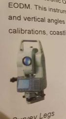
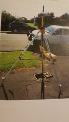
Total station |
Horizontal and vertical angles and distances, undertakes ships survey calibrations, coastlining and object positioning. |
|
|
|
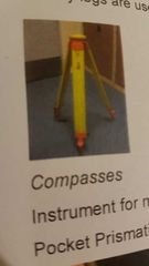
Survey legs |
Leveling and supporting survey instruments |
|
|
|
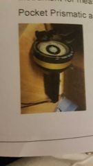
Compasses |
Measures magnetic bearings. - Pocket Prismatic - Deadbeat Compass |
|
|
|
Phsychrometers/Barometers |
Measures wet and dry temperatures and determines barometric pressure. 2 types - whirling psychrometer -aspirated psychrometer |
|
|
|
S4 Current Meter |
Determines speed and direction of tidal stream at a set depth |
|
|
|
Tide pole |
5 meters long tantalized pine with stave plates attached Observes tide rise and fall |
|
|
|
Valeport Tide Gauge/Tide master |
Automatic tide pole Measures tidal rise and fall |
|
|
|
Side Scan Sonar |
Sideways looking sonar, gives coverage and feature detection between sounding lines |
|
|
|
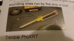
Trimble ProXRT |
Instrument used for the coastlining and obtaining WADGPS positions |
|
|
|
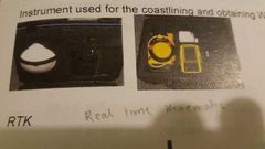
RTK (real time Kinematic) |
Creates a temporary survey mark |
|
|
|
RTK acronym |
Real time kinematic |
|
|
|
Level |
|
|
|
Tachstaff |
|
|
|
Total station |
|
|
|
Survey legs |
|
|
|
Compasses |
|
|

|
Psychometer/Barometer |
|
|

|
S4 current meter |
|
|
|
Tide Pole |
|
|
|
Valeport Tide Gauge/ Tide Master |
|
|
|
Side Scan Sonar |
|
|
|
Trimble Pro XRT |
|
|
|
RTK |
|
|
|
Where can you find HST Equipment |
Commander William Smith Building (MHG) OR NSD (Naval Supply Depot) |
|
|
|
What is the AHSO's job at HTA? |
-maintain the whereabouts of equipment - monitor equipment condition - The preparation and return of equipment for deployment |
|
|
|
Gathering and checking equip prior to deployment |
-Receive task -Gather and assemble all equipment Check thoroughly -Report, rectify, repair, replace defective units -LHST or OIC will check again before deployment |
|
|
|
Common survey faults |
-Missing Screws, nuts, bolts, L-Keys - Bent metalwork - Jammed Parts - Loose Parts - Corrosion - Cracked Glass - Batteries not Charged - Equipment out of calibration date |
8 things |
|
|
Guidelines before handling equipment |
- Read equipment handbooks/SOPS - Question Senior Surveyors - observe how equipment fits/ clamps prior to removal - never force anything - use rubbish bags to protect equipment when transmitting by RHIB |
5 things |
|
|
Types of survey Mark's used in NZ |
Geodetic Mark's Bench Mark's Temporary Mark's |
3 of them |
|
|
Geodetic Mark's |
Used for horizontal control |
|
|
|
Bench Mark's |
For all vertical control |
|
|
|
Temporary Mark's |
Temporary positioning during various survey tasks |
|
|
|
Types of Mark's encounter by a surveyor |
Brass RNZN trig plate Brass RNZN benchmark Stainless steel terrier bolt Galvanised iron tube Angle Iron stake Brass DOSLI/LINZ survey plate Cairn or pillar Wooden or metal Trig Station An arrow cut into concrete or rock (type of benchmark) |
9 types |
|
|
How to identify an appropriate location for Mark's |
Permanance Observation suitability Visibility Height Access Security Background Light Clearing Ease of recovery |
10 |
|
|
Permanance |
Mark location Ground unlikely to subside or be covered by vegetation |
|
|
|
Observation suitability |
Mark location Ease to set up equipment and protect it from the weather |
|
|
|
Visibility |
Able to see as much of the survey area, good sky visibility (GPS) |
|
|
|
Height |
Depends on station requirements |
|
|
|
Access |
Mark location Easy access by land, sea, or air desirable |
|
|
|
Security |
Mark location Value of equipment being left at the station |
|
|
|
Background |
Mark location Sited aagainst plain background so they stand out |
|
|
|
Light |
Mark location Placed in the open - easier to see |
|
|
|
Clearing |
Minimum environmental impact required |
|
|
|
Ease of recovery |
Mark location Easy to find if needed again - properly ground marked - easily found - adequately described on a Mark and site detail form |
|
|
|
Info needed to complete a mark and site detail form |
-Geodetic code - mark type - name - land district - NZMS 270 Reference - NZMG Ref -plans ref - Date of inspection - Established by - Date Established - ID Plaque - ID Plate - Mark Description - Protection type - Protection structure description - Land Owner/ Contact - Access Restrictions - Access notes - GPS Suitability and Cellphone Coverage - Location Access Diagram - Maintenance/ visit record -Date Beacon erected/ Beacon type Beacon Eccentricity - Beacon Diagram - Beacon Eccentricity - Beacon Diagram - Photographs Once completed it will be checked - Photographs Once completed it will be checked |
25 |
|
|
Tribrach |
Metal bracket that sits on the survey legs |
|