![]()
![]()
![]()
Use LEFT and RIGHT arrow keys to navigate between flashcards;
Use UP and DOWN arrow keys to flip the card;
H to show hint;
A reads text to speech;
57 Cards in this Set
- Front
- Back
|
Purpose of Street and Highway Design |
has an impact on how we live, travel, and issues of sustainability. to create vibrant, safe and prosperous places |
|
|
Street design Philosophy |
Streetdesign must accommodate a wide variety of uses including walkers,wheelers, drivers, businesses, residents, parked vehicles, dinners, bus loading, shared use vehicle docks, trees, drainage. People on foot bring life and vitality to places. |
|
|
Era of Placemaking |
Philly-1682 Savannah, GA-1733 Washington, DC-1792 |
|
|
Automobile Era 1910-1950 |
poor road conditions, cars were stuck in the mud
|
|
|
Good Roads Movement 1880-1916 |
-rural roads unpaved -movement led by bicycle groups -CT gov. signed Good Roads Act (1895) -Road building began (1902) -CA concrete demonstration highway (1916) -$75 mil offered to states to improve rural roads -First Nationwide system of roads and highways (1921) -Limited access highway opens (1921) -First Cloverleaf (1928) -Merritt Parkway (1938) |
|
|
What is a Freeway |
1.MedianDivider to separate each direction of traffic 2.Accessis limited to interchanges 3.GradeSeparated Intersections |
|
|
Street and Highway Design: 1920s and 30s |
Two approaches: 1.Interdisciplinary Context OrientedDesign BlueRidge Parkway, Merritt Parkway 2.Engineer Oriented Design Practicedby most highway departments Beginning of unified codes in 1930s |
|
|
The National Park Service1920s and 30s
|
blends talent of engineers, architects and landscape architects of the 1920sto produce a happy marriage between aesthetics and function.
|
|
|
Birth of AASHTO |
to provide technical guidance ongeometric design for motor vehicles
|
|
|
AASHTO Design and FunctionalClassification
|
cul-de-sac: astreet that is designed to connect to another street only at one end
|
|
|
Context Sensitive Solution
|
1.shared stakeholder vision
2 understanding of contexts; 3.continuing communication and collaboration 4.creativity to shape effective transportationsolutions, while preserving and enhancing community and natural environments. |
|
|
ISTEA
|
emphasizes the importance of design that is sensitive to the surrounding environment,especially in historic and scenic areas
|
|
|
Complete Streets
|
-streets for everyone.
-designed and operated to enable safe access for all users -make it easy to cross the street, walk to shops,and bicycle to work. -allow buses to run on time and make it safe forpeople to walk to and from train stations.” |
|
|
Observations of good streets |
-varied indesign, function and context
- need the variation to serve the range of contexts in towns and cities - consistent with the design of the surrounding land use and function of the street in overall transportationnetwork |
|
|
System Time |
-TrafficBehavior Governs
-Singlepurpose - Regulated -Impersonal -Uniform - Predictable -vehicles operate safely at high speeds |
|
|
Context Time
|
Social Behavior Governs
-Multi-functional -Culturallydefined -PersonalDiverseUnpredictable -best in shared space design -controlled speed of vehicles |
|
|
Assessing the Laweiplein
|
Lesscongestion - timethrough intersection decreased by50%
constant traffic speed Vehiclescede priority to bikes and pedestrians Fewertraffic accidents Higherquality of public space Ex. Kensington High, Exhibition street |
|
|
Speed and The Role of the Designer
|
-Speedis the most important parameter for streets and highways design
-design impacts speed chosen bydrivers -role of the designer with respect to designing for speed varies, depending onif we are designing for context time or system time |
|
|
AASHTO DefinitionOperating Speed
|
-The speed at which drivers are observed operating their vehicles during free-flow conditions
-not encumbered by congestion or weather or other adverse conditions1A49EB} |
|
|
AASHTO DefinitionRunning Speed
|
-speed at which an individual vehicle travels over a highway section
-affected by congestion and weather |
|
|
AASHTO Definition Design Speed
|
A selected speed used to determine the various geometric design features of the road way
|
|
|
What is the Purpose of AASHTO Classification Schemes for Street and Highway Design?
|
determines issues such as the appropriate speed and the type of facility
|
|
|
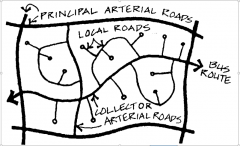
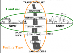
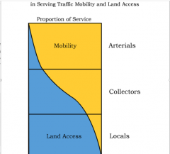
TheBasis ofAASHTO’s Functional Classification
|
Two elements of functionalclassification are 1.Land use contexts: Ruraland Urban2.Roadway types: Arterials,Collectors and Locals
|
|
|
FunctionalClassificationABird’s EyeView
|
|
|
|
AASHTO’s definitions for land use context
|
Urban: Thoseplaceswithin boundaries set by the responsible state and local officialsin areashaving a population of 5000 or more
Rural: Areasoutsidethe boundaries of urban areas |
|
|
AASHTOStreet and Highway Types
|
|
|
|
AASHTO Street and Highway Types
|
|
|
|
UrbanAreas
|
-Principal Arterials - high volumes, long trip length
-Minor Arterials -moderate trip length -Collectors - trips serving neighborhoods bycollecting traffic from local streets -Local- roads primarily for providing access to properties |
|
|
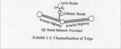
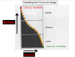
Translatingthe S-Curve into Design
|
|
|
|
Shortcomingsof AASHTO Functional Classificationfor Designing Urban Streets
|
1.Doesnot support design of an urban street network: AASHTO is consistent with thehierarchical street network.
2.Norecognition that streets can be multifunctional: The access/mobility curve impliesthat a given roadway needs to be somespecific mix of access or mobility. Main streettype facilities are not allowedbased on this curve. 3.Descriptionof land use is too coarse: TheAASHTO functional classification defines land use as either rural orurban. In order to better understand theland use context we need a finer grained description of land use context. 4.Doesnot characterize facilities in terms of design features: The terms arterial, collect andlocal do not tell the designer enough about appropriate designcharacteristics of the road.5.Providesno guide concerning facility/land use compatibility: The AASHTO method ofclassification gives no guidance to the designers as to what type of facilityis appropriate for a given context. |
|
|
ITE/CNUstreet classification
|
1.UrbanNetworks:Aconnected urban network of streets 2.FineGrained Land Use Type: Transectzones are used. Transect zones weredeveloped specifically for characterizing land use types. 3.FacilityType based on Design Characteristics: Thoroughfaretype is used to characterize the facility type for design 4.Landuse/Facility Type Compatibility is Specified: ITE/CNUexplicitly define compatibility between Transect Zone and Thoroughfare Type
|
|
|
ITE/CNUStreet ClassificationList of Thoroughfares: Rural vs Urban
|
Rural: Highway, Expressway, Road, Freeway
Urban: Boulevard, Avenue, Drives, Streets, Lanes, Alleys,Mews |
|
|
Boulevard (BV):
|
designedfor high vehicular capacity moderatespeed,traversing an Urbanized area. multi-way thoroughfares Target Speed: 25 to 30 mphinner, 20 mph outer |
|
|
Avenue (AV) |
high vehicular capacity low to moderate speed short distance connector between urban centers equippedwitha landscaped median TargetSpeed: 20 to 25 mph |
|
|
Street (ST): |
low speed and capacity TargetSpeed: 15 to 20 mph |
|
|
Drive (Dr.) |
along boundary between an Urbanized and a naturalcondition
along waterfront, Park, or promontory. One side has the urbancharacterof a Thoroughfare, with Sidewalk and building, other has thequalitiesof a Road or parkway, with naturalistic planting and rural details. TargetSpeed: 15 to 20 mph |
|
|
Some Differences between Streetsand Roads
|
Roads: shoulders,side slopes, open drainage, guide rails
Streets: no shoulders, side slopes, open drainage orguide rails, have curb, roadside with cultivated trees, sidewalks, buildings up to sidewalk |
|
|
Street Network |
Pattern of street network
Scale of street network Scale of the streets Relationship of buildings to the street Street as an organizing mechanism |
|
|
Characterizingthe the Street NetworkD
|
Shapeand Configuration
StreetNetwork Scale StreetNetwork Connectivity PorosityBetween Neighborhoods (Segmentation) |
|
|
Streets& Patterns
|

|
|
|
Calculatingthe Street Network ScaleIntersectionDensity per Square Mile
|
Numberof intersections in amile along the Xdirection = (5280/600) + 1 = 10.0
Numberof intersections in amile along the Ydirection = (5280/400) + 1 = 14.0 IntersectionDensity = 10.0 X 14.0 =140 Intersections per square mile |
|
|
Variablesincluded in Our Safety and Travel Choice Models
|
StreetNetwork Properties
StreetDesign Properties: Average Total Number of Lanes, Average Outside Shoulder Width, Raised Median, Painted Median, On-Street Parking, Bike Lanes, Raised Curbs Traveland Activity Level Distancefrom City Center Income Mixof Land Use |
|
|
Principles or Goals forSustainable Urban Street Networks(from the CNU Blue Book)
|
1.Support community and place
2.Attract and sustain economicactivities3.Maximize transportation choice 4.Integrate with natural systems 5.Respect the existing natural andbuilt environment 6.Emphasize walking as thefundamental unit of design 7.Work with other transportationnetworks |
|
|
Featuresof aGood Urban Street Network
|
1. HighDensity of Intersections
2. HighConnectivity within Neighborhoods3. GoodPorosity Between Adjacent Neighborhoods 4. Variety in Streets Types 5. NoRestrictions on street types 6. walkable and crossable and multipurpose 7. building frontage |
|
|
Whatare the factors contributing to difference between streets types?
|
•Streetcross-section design
•Continuityof street in the network •Typeof intersection connection in the street network •Streetalignment in the street networkNotethat these are a combination of 1)Featuresof the street itself 2)Featuresof the street network |
|
|
Whatare the State Traffic Counts Used for?AADT
|
-Thestate traffic count is used to estimate average annual daily traffic (AADT)
-Total Traffic in year / 365 |
|
|
TrafficFlow and Capacity for Street and Highway Design
|
TrafficFlow: characterized by a design hour volume
Capacity: characterized by design hourlyservice volumeF |
|
|
design hour volume body>
|
-volumeof traffic that will use the facility in the designhour,in the design direction, inthe design year
-estimatedfrom AADT |
|
|
UnderstandingCapacity for Vehicle Travel>
|
number selected based on whatlevel of congestion we are willing to put up with
|
|
|
OS-Biloxi BridgeSampleCalculation
|
Trafficflow in the peak direction = 32,000*design direction split =32,000*0.6 = 19,200Trafficflow in peak direction, in design hour = DVH =19,200*(fraction of ADT in design hour) =19,200*0.124 = 2380.8DHSVfor LOS of E = 2000Therefore,number of lanes is DVH/DHSV = 2380.8/2000 =1.19 lanesUse1 lane in each direction
|
|
|
Essential Elements of urban street design |
1.Connectedand Complete Street Network
2.Convenience,Comfort and Safety for Vulnerable Road Users 3.Senseof Place |
|
|
DesignFeatures Affecting Sense of Place
|
-BuildingOrientation on Site
-BuildingDesign -ParkingDesign -Type and Orientation -BlockLength -StreetCross-section Design |
|
|
Typesof Biking Facilities
|
-Sharedstreets and shared lanes
-Bikelanes:Separation by roadway striping (orbuffered) -Separatedpaths |
|
|
Conditionsfor Shared Streets |
-Low speed -Low traffic -No lane markings |
|
|
Guidelinesfor Width of Bicycle Lanes |
-7 ft fromparked cars
-14.5 ft from thecurb. 5ft wide bike lane could yield a reach ranging from a very tight 12 ft to agenerous 15 ft.”tr=(not%20provided) |
|
|
Densityof Biking Facilities in the Network
|
WithinNeighborhood frequency of less than 1/6 of a mile.
BetweenNeighborhood longer distant travel, less than 0.5miles spacing |
|
|
factors contributing to Intersectionsprawl$
|
1.Larger turning radii
2.Wider lanes 3.More turning pockets (more lanes atintersection) |