![]()
![]()
![]()
Use LEFT and RIGHT arrow keys to navigate between flashcards;
Use UP and DOWN arrow keys to flip the card;
H to show hint;
A reads text to speech;
49 Cards in this Set
- Front
- Back
|
What is a great circle |
A circle drawn on a sphere. It's centre is the same as the sphere. It's the largest circle that can be drawn on the sphere. |
|
|
What is a small circle |
Circle drawn on a sphere. Centre is not shared with the sphere. Circumference will always be less than the spheres |
|
|
What is a rhumb line |
A line that crosses meridians at the same angle. Used for navigation for distances less than 1000nm. |
|
|
What are three ways to measure distance on maps without a ruler |
1:250 000, thumb to first knuckle = 5nm 1:500 000, thumb to first knuckle = 10nm 1 deg of Lattitude = 60nm, so 1 min of Lattitude= 1nm. Same for longitude only at equator. Only measure on Meridian lines, never Lattitude lines |
|
|
AVOs fuel requirements |
a. Unusable Fuel. 0 lbs. b. Ground Handling Fuel. 50 lbs c. Minimum Fuel. 100 lbs. d. Pre Take-Off Fuel. 50 lbs. e. En route Fuel. As calculated using the Aircraft Flight Manual (AFM). f. Diversion Fuel. If required, to include: 1. missed approach at destination 35lbs, plus 2. transit to alternate, plus 3. approach at alternate 70lbs, plus g. Holding Fuel. 100 lbs (15 minutes at 400 PPH). h. Identified Extra Fuel. As required. i. Contingency Fuel. Five percent of en route fuel and five percent of diversion j. Approach and Landing fuel |
|
|
How to compute MSA |
Highest spot height or obstacle height within the affected area (MFA in VNC/R470), rounded up to nearest hundred, plus 1000’ or 2000’ in mountainous terrain |
|
|
How to recognise and treat sensitive areas |
Hollow yellow circle – Avoid by 1000’ or 1nm |
|
|
How to recognise and treat Danger Areas |
NZ D### - Red line Captain can enter after due consideration of the danger present – entry at your own risk |
|
|
How to recognise and treat Restricted Areas |
NZ R### - Red line Cannot enter until authorised by the administering authority
|
|
|
How to recognise and treat Mandatory Broadcast Zones |
NZ B### - Blue dotted line Requires broadcast position, alt, intentions – On Entry, joining circuit, prior to entering a runway, at specified regular intervalsLanding/Anti-Col lights on if fitted Aircraft without radio can only enter in form with a/c broadcast on behalf, or UNICOM broadcasting on behalf |
|
|
How to recognise and treat Low Flying Zones |
NZ L### - Solid blue line Surface to 500’ AGL Requires brief from responsible agency, must comply with conditions of ops Requires broadcast details of flight & proposed duration |
|
|
How to recognise and treat Volcanic Hazard Zones |
NZ V### - Solid red line VMC, by day only Advised by SIGMET Level 1 – 3nm rad Level 2 – 8nm, FL150 upper limit … Level 5 – 50nm, FL660 upper limit
|
|
|
How to recognise and treat a Common Frequency Zone |
NZ C### – Hollow Blue Diamonds Not mandatory for radio, but poor airmanship to not At minimum, broadcast positions and intentions on entry/exit Landing, Anti-Cols recommended |
|
|
How to recognise and treat Parachute Landing Areas |
PLA – Red parachute Treat as danger area, particularly upwind side Overhead join not recommended Often special procedures at popular ones |
|
|
Limitations of RNAV/RNP |
RNAV 1, 2, 5: Within Xnm of planned track 95% of the time RNP 1, 2, APCH: Within Xnm 95% of the time, and 2Xnm 100% of the time |
|
|
How are Lattitude and Longitude written? |
Always Lat first – Lat gives N/S, Long gives E/W 3 Formats Degrees decimal degrees S40.2002° E175.3781° Degrees minutes decimal minutes S40° 12.010’ E175° 22.684’ Degrees minutes seconds decimal seconds S40° 12’ 00.61” E 175° 22’ 41.04” |
|
|
How do you plan IMC climbs en-route |
Anchor yourself in VMC conditions. Scan 30 deg L/R to define climb sector (inside front canopy bow) Determine MEF, if more than one use highest. Determine MSA (+1000’ or 2000” mountainous Calculate climb radius - (MSA – current alt), divide by 1000, multiply by 2, gives nm climb area Once ready, set PCL Max, accelerate, get on track, set 140 Climb att, contact ATC. |
|
|
How are IFR flight plans submitted or closed? |
Submitted no more than 24 hours before, no less than 30 mins before WOCT If landing in controlled, cancelled automatically by ATC. If landing in uncontrolled, need to ask ATC to cancel, or ring on phone and cancel. |
|
|
Describe the features and properties of Mercator Projection |
Cylindrical projection, appears rectangular, can be transverse Lines of latitude and longitude are straight lines Scale, spacing of lines of latitude increases towards the pole Scale constant near equator, 12 deg, used for mapping for the world other than the poles
Properties Orthomorphic Rhumb lines are straight lines, Great circles curve nearer the poles Scale increases with distance from equator - Areas aren’t equivalent Poles cannot be projected (due to Earth’s convergence) Adjacent sheets fit together |
|
|
Describe the features and properties of Lambert's Conformal projection |
Projection is of a portion of a sphere onto a cone Utilises reference parallels of latitude where no distortion is present Distortion increases further from the reference parallels Widespread mapping except for polar latitudes
Properties: Map is orthomorphic (conformal) between the reference parallels Scale considered constant – contracted slightly between parallels and expanded slightly beyond them Great circles are straight lines Rhumb lines curve towards the poles Equivalence achieved over small areas |
|
|
What are isogonals |
Isogonals are lines of equal magnetic variation, similar concept to contours |
|
|
Describe the datums used globally and for NZ |
WGDS 84 World geodetic system84 used for GPS and mapping NZGD2000 can be considered the same |
|
|
What are the VFR met minimas? |
VFR Min Aerodromes w/in CTZ: Day & Night – 1500ft, 5km Aerodrome in uncontrolled: Day – 600ft, 1.5km, Night 1500 ft, 8km VFR Distance from cloud C & D – 2km horizontal, 1000’ vertical (500’ in CTZ) G – Above plane of division – 2km horizontal, 1000’ vertical G – Below plane of division – Clear of cloud, in sight of surface
|
|
|
What are the properties of an ideal map |
Orthomorphic/Conformal Scale constant and correct (never quite possible – only possible on a globe) Shapes correct (never quite possible, as above) Equivalence – areas correctly represented Adjacent parts fit correctly Rhumb line as a straight line, great circle as a straight line |
|
|
How do we corner cut, and work out the time saved |
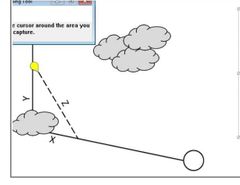
Time saved = (X+Y)-Z Every one min before the corner = gain 25-30 secs for 90 deg angle Don't pick a small back on track feature |
|
|
What are the forms of terrain clearance indicated in charts? |
VNC/VPC/R470: MEF max elevation figure, blue number in quadrangles for highest feature. Enroute/area chart ASA Area safe altitude. MSA IFR high/low.
|
|
|
What given a scale, how far is 1cm on a map |
1:500,000 = 1cm is 5km or 2.7NM 1:250,000 = 1cm is 2.5km or 1.35NM |
|
|
What are the standard closing angles? |
210kts= 17 degrees 180kts= 20 degrees 150kts= 24 degrees
|
|
|
How many feet in a kilometre |
1000m = 3280ft |
|
|
How many feet in a nautical mile |
1nm = 6076.1 feet |
|
|
Standard landing assumptions from flight manual chart? |
Final appch speed as tabulated. 3 degreee glide slope descent to 50 ft Idle power at 50ft Min flare at touchdown Max braking without skidding Hard surface runway
|
|
|
What assumptions are made for cruise phase assumptions |
Gear/flaps retracted unless stated otherwise |
|
|
Relate variation and deviation |
The angular difference between the direction of True North and Magnetic North at any given point is called Variation Deviation is the angular difference between Magnetic North and Compass North |
|
|
What are the three types of North? |
True North: The direction towards the North Pole following the line of a meridian Magnetic North: The direction a freely suspended magnet will point. Exact position varies with time – approx 900 nm from True North Compass North: The direction taken up by a compass needle. Can differ from Magnetic North due to local magnetic fields, compass inaccuracy and aircraft magnetism
|
|
|
What is the definition on Longitude? |
Shortest angular distance from prime meridian to meridian through that point. |
|
|
Deviations and time lost without changing speeds |
|
|
|
Speeds of the mighty T6-C Texan when low flying |
Max 240 KIAS Min 180, (but not below 140!) KIAS Normal 210 GS
|
|
|
Fuels the Texan can accept? |
JP4 JP5 JP8 Jet A Jet A1 Jet B
|
|
|
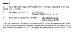
Calculation for calculating Rate of Climb |
|
|
|
Effects of altimeter flying from area of high pressure to area of low pressure? |
High to low watch out below, altimeter will show higher than true. |
|
|
Engine temperature management and use of ITT in climb and cruise |
- ITT not to exceed 820 deg. So for max climb power we set a PCL position to provide 13 Deg below max observed ITT at critical altitude (Not to exceed 807 deg). - Cruise power. Set a PCL position which yields 40 deg below max observed ITT at critical altitude. (Not to exceed 780).
|
|
|
Describe latitude and longitude |
•Latitude is the angular distance from the equator to a point, measured through the meridian to that point. Expressed in degrees North or South according to the position relative to the Equator (0°) •Longitude is the shorter angular distance between the prime meridian and the meridian running through that point. Expressed in degrees East or West according to whether the point lies East or West of the prime meridian (Max 180°)
|
|
|
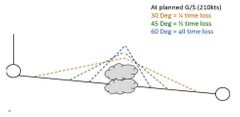
What deviations can we use? Describe them |
Corner cut
Parallelogram
Triangle (dog leg) - At planned G/S (210kts) 30 Deg = ¼ time loss 45 Deg = ½ time loss 60 Deg = all time loss
Or The following 1 minute ‘dog-legs’ with no time penalty based off 210 KTS:
10°off, increase GS by 3 KTS, therefore fly just a little faster than 210 KTS – Don’t fly slower!
20°off, increase GS by 15 KTS, therefore fly 225 KTS GS.
30°off, increase GS by 30 KTS, therefore fly 240 KTS GS
|
|
|
Decode Metar/Taf/ Grafor etc. |
Grafor Clouds are AMSL All other forecast clouds are AGL Only wind that is magnetic is ATIS. All other winds True. |
|
|
AVOs definition of low flying limitations |
Built up areas inside 1,000AGL vertically or 600m horizontally. Rural areas Inside 500’AGL vertically or 150m horizontally.
|
|
|
What is area safe alt, operating safe alt, leg safe alt,? |
Area Safe Altitude (ASA) is an MSA calculated within an effective area that is 30 nm(horizontally) either side of the intended track/area, including a 30 nm radius aroundwaypoints and any departure/arrival aerodromes. Operating Safe Altitude (OSA) is an MSA calculated within an effective area that is10 nm (horizontally) either side of intended track/area, including a 10 nm radiusaround waypoints and any departure/arrival aerodromes. Leg Safe Altitude (LSA) is an MSA calculated within an effective area that is 5 nm(horizontally) either side of intended track/area, including a 5 nm radius aroundwaypoints and any departure/arrival aerodromes.
|
|
|
What is convergence how does it affect rhumb line? |
•Meridians are only parallel at the Equator and converge towards the poles, known as Earth’s Convergence. •Rhumb lines are curved but hold the same course/common bearing |
|
|
What is othomorphic why is it good? |
•Angles correctly represented •Meridians and parallels intersect at right angles •Therefore - bearings can be accurately measured •Scale North/South and East/West at a point on the map are the same (not necessarily same at different points on the map
|
|
|
What is critical altitude? |
Altitude at which 100 % TQ is no longer available. About 16,000AMSL for ISA |