Reading...
![]()
Play button
![]()
Play button
![]()
Use LEFT and RIGHT arrow keys to navigate between flashcards;
Use UP and DOWN arrow keys to flip the card;
H to show hint;
A reads text to speech;
67 Cards in this Set
- Front
- Back
- 3rd side (hint)
|
What are the 5 fields of social studies?
|
Culture
Economics History Geography Government |
Hint: C.E.H.G.G. "Chad eats hairy gopher guts!"
|
|
|
What is Culture?
|
Beliefs, customs, laws, art, and ways of living that people share.
|
Hints Disco
|
|
|
What is Economics?
|
How people manage their resources by producing, exchanging, and using goods and services. Economics is about choice.
|
|
|
|
What is Geography?
|
The study of the earth and the people who live on it.
|
|
|
|
What is Government?
|
People and groups within a society that have authority to make laws.
|
|
|
|
What is limited government?
|
Everyone must obey the laws
|
|
|
|
What is unlimited government?
|
Rulers can do whatever they want. (dictators, totalitarians)
|
|
|
|
What are the Five themes of Geography?
|
Location
Region Place Movement Human-Interaction |
L.R.P.M.H.
Lions Really Part More Hair |
|
|
Geography - Theme One
What is location? |
The position of a place on the earth's surface
|
|
|
|
What is relative location?
|
The position of a place in reference to another place (my house is two blocks north of HEB)
|
|
|
|
What is absolute location?
|
The exact location of a city using longitude and latitude.
|
|
|
|
Geography - Theme Two
How is a place determined? |
"What is it like there?" The features and characteristics that give an area its own personality.
|
|
|
|
Geopgraphy - Theme Three
Human Interaction with the environment refers to?... |
How people use, adapt to, or change their surroundings. Examples are irrigation, fencing in land, clearing a forest, etc.
|
|
|
|
Geography - Theme Four What is movement?
|
People interacting across the globe with the movement of people, ideas, and goods. Examples are driving a car built in Japan, sharing a culture brought in from distant countries, using the Internet to share ideas.
|
|
|
|
Geography - Theme Five What is a region?
|
A region is an area unified by a similar feature. Examples: mountains, plains, desert.
|
|
|
|
Review your map of the continents and oceans now.
|
REALLY! GET UP RIGHT NOW AND DO IT !!!!
|
|
|
|
What is a canyon?
|
a deep, narrow valley with steep sides.
|
|
|
|
What is a delta?
|
A triangular area of land formed from deposits at the mouth of a river.
|
|
|
|
What is a desert?
|
A dry area where few plants grow.
|
|
|
|
What is a mesa?
|
A wide, flat-topped mountain with steep sides, larger than a butte.
|
|
|
|
What is a mountain?
|
A natural elevation of the Earth's surface with steep side and higher than a hill.
|
|
|
|
What is an oasis?
|
A spot of fertile land in a desert, supplied with water by a well or a spring.
|
|
|
|
What is a plateau?
|
A broad flat area of land higher than surrounding land.
|
|
|
|
What is a steppe?
|
A wide, treeless plant.
|
|
|
|
What is a valley?
|
Low land between hills or mountains.
|
|
|
|
What is fertile land in a desert called?
|
Oasis
|
|
|
|
What is the difference between a cape and an island?
|
A island isn't connected to land and a cape is connected to land.
|
|
|
|
Which is the only landform that moves?
|
A glacier
|
|
|
|
What is the difference between a mesa and a mountain?
|
A mesa is flat at the top and a mountain is not.
|
|
|
|
Which landform describes the low land between hills or mountains?
|
A valley
|
|
|
|
What is Longitude?
|

Imaginery lines that run north and south; they are also known as meridians. They show distances in the degrees east or west of the prime meridian.
|
|
|
|
What is the prime meridian?
|
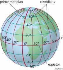
The prime meridian is a longitude line that runs from the North Pole to the South Pole through Greenwich, England.
|
|
|
|
The Prime Meridian is located a _____ degrees longitude?
|
Zero
|
|
|
|
What is latitude?
|
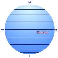
Latitude lines are the imaginery lines that run east and west around the globe. They are also known as parallels.
|
|
|
|
Latitude lines show distances in degrees north or south of the___________
|
equator.
|
|
|
|
The __________ is a latitude lines that circles Earth halfway between the north and south poles.
|
The equator.
|
|
|
|
The tropices of __________ and __________ are parallels that form the boundaries of the tropical zone, a region that stays warm all year.
|
Cancer & Capricorn
|
|
|
|
A person who makes maps is called a....?
|
Cartographer
|
|
|
|
What are thematic maps?
|
They focus on specific themes or ideas. Examples: vegatation, population density,
|
|
|
|
Map projectsion have different ways or showing the earth's _______ _______ on a flat map.
|
Curved surface
Examples are Mercator projection and Robinson projection. |
|
|
|
What is the mercator projection?
|
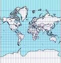
For more than 400 years, Mercator Projection was most often shown on maps of the world.
|
|
|
|
What is the Robinson Projection?
|
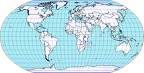
Recently, the Robinson Projection has been used because it shows a more accurate picture.
|
|
|
|
What are the differences between the Mercator projection and the Robinson projection?
|
1. The Robinson projection is curved on the sides and the Mercator Projection isn't.
2. The continents on the Robinson Projection is bigger, the mercator is not. |
|
|
|
What do we call the two sets of lines that geographers have created to help locate places on a map or globe?
|
Latitude and Longitude
|
|
|
|
What are the two lines that divide the earth into the Northern and Southern Hemisphere and the Eastern and Western Hemispheres?
|
Equator, Prime Meridian
|
|
|
|
What percentage of the earth's surface is covered by water?
|
70%
|
|
|
|
Name all four oceans...
|
Pacific
Atlantic Artic Indian |
|
|
|
What percentage of the water found on the earth is fresh water?
|
3%
|
|
|
|
What are the three stages of the water cycle?
|
1. Evaporation
2. Condensation 3. Precipitation |
|
|
|
Name all seven continents
|
North America
South America Europe Asia Australia Antartica Africa |
|
|
|
What are the four basic types of landforms found on the earth?
|
Plain
Plateau Island & Peninsulas Mountains |
|
|
|
What name have geographers given to the movement of the continents over millions of years?
|
Continental Drifts
|
|
|
|
Where woul you be more likelyh to find a large population center; on top of a high mountain, or on a coastal plain?
|
Coastal Plain
|
|
|
|
What is a title on a map?
|
The title indicates the subject of the map and tells you what information it contains.
|
|
|
|
Describe the symbols on maps
|
Symbols may stand for capital cities, economic activities, or natural resources.
|
|
|
|
What do colors indicate on a map?
|
Colors show a variety of information on a map. The map legend tells what the colors mean.
|
|
|
|
What are labels used for on maps?
|
They are words and phrases thta name features on the map.
|
|
|
|
What are lines of longitude?
|
Imaginary lines that show distances east and west of the prime meridian.
|
|
|
|
What are the lines of lattitude?
|
Imaginery lines that show distances north and south of the equator.
|
|
|
|
What is a Legend (or key)
|
Lists that explain the symbols and colors used on the map.
|
|
|
|
What is the compass rose?
|
The compass rose shows you north (N), south (S), east (E), and west (W)on the map. Sometimes only North is shown.
|
|
|
|
What is the scales
|
The scale compares a unit of length on the map and a unit of distance on the earth.
|
|
|
|
Study the Time Zone Map
|
NOW!!! RUN!!!!! STUDY IT!!!!
|
|
|
|
What time zone is Austin, TX located in?
|
Central
|
|
|
|
What time zone is Los Angeles, CA in?
|
Pacific
|
|
|
|
What time zone is Atlanta Georgia located in?
|
Eastern
|
|
|
|
What time is Phoenix, Arizona located in?
|
Mountain
|
|