![]()
![]()
![]()
Use LEFT and RIGHT arrow keys to navigate between flashcards;
Use UP and DOWN arrow keys to flip the card;
H to show hint;
A reads text to speech;
6 Cards in this Set
- Front
- Back
|
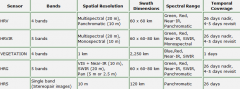
SPOT 1,2,3 |
2 VHR sensors: VHR contains three spectral bands/multispectral (Green, Red, Near-IR) at a 20 m spatial resolution and a panchromatic band at a 10 m spatial resolution. |
|
|
Payload: types of sensors (5) for SPOT 1-3, 4 and 5 |
SPOT 1-3: VHR SPOT 4: HRVIR & VEGETATION SPOT 5: HRG (high ver of HRVIR), HRS |
|
|
Comparison with TM Improvements of SPOT over TM (4) |
1. Higher spatial resolution 2. Higher geometric fidelity 3. Capability of recording data at off-nadir position 4. ability to obtain 3D viewing |
|
|
Advantages of TM imagery (2) |
high spectral res broader ground coverage |
|
|
analysis: how? which elements are more important |
similar to aerial photographs tone/colour, texture and pattern more revealing than size (smaller than on photos, hard to tell for indiv objects), shadow, shape, location |
|
|
background info more or less important role in interpreting satellite iamgery
|
MORE important.. especially small-scale ones |