![]()
![]()
![]()
Use LEFT and RIGHT arrow keys to navigate between flashcards;
Use UP and DOWN arrow keys to flip the card;
H to show hint;
A reads text to speech;
54 Cards in this Set
- Front
- Back
- 3rd side (hint)

Front (Term) |
: |
|
|
|
When was limestone formed? |
Carboniferous period, 360 million years ago |
|
|
|
What are the characteristics of limestone? |
It has: Layers Beds Contains fossils Is tough Weaker than metamorphic and igneous rocks |
|
|
|
How was it formed? |
By the compaction and cementation of sediments, usually deposited in the sea. |
|
|
|
How was it formed? |
By the compaction and cementation of sediments, usually deposited in the sea. |
|
|
|
Where is limestone found in the uk |
Above the tees-exe line, North England, Yorkshire dales, Peak District, Cumbria, Pennines, South of grampians, Northern Ireland |
|
|
|
How was it formed? |
By the compaction and cementation of sediments, usually deposited in the sea. |
|
|
|
Where is limestone found in the uk |
Above the tees-exe line, North England, Yorkshire dales, Peak District, Cumbria, Pennines, South of grampians, Northern Ireland |
|
|
|
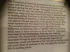
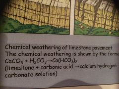
Why Carboniferous limestone produces distinctive landforms: |
Chemical weathering: rain water contains carbon dioxide in solution (carbonic acid). It is a weak acid, it reacts with rocks (Calcium carbonate, limestone) it dissolves it slowly and removed it in solution by running water. Chemical weathering allows the rock to decompose where they are located Rock structure: sedimentary rocks are laid down in layers, each layer is separated by a bedding plane. Joints and bedding planes are areas of weakness which are dissolved and widened by chemical weathering Permeability: Carboniferous limestone is pervious, unlike chalk which is porous. Porous rock consists of many small pores which allow water to pass through it. A pervious rock restricts water flowing along bedding planes and down joints |
|
|
|
How was it formed? |
By the compaction and cementation of sediments, usually deposited in the sea. |
|
|
|
Where is limestone found in the uk |
Above the tees-exe line, North England, Yorkshire dales, Peak District, Cumbria, Pennines, South of grampians, Northern Ireland |
|
|
|
Why Carboniferous limestone produces distinctive landforms: |
Chemical weathering: rain water contains carbon dioxide in solution (carbonic acid). It is a weak acid, it reacts with rocks (Calcium carbonate, limestone) it dissolves it slowly and removed it in solution by running water. Chemical weathering allows the rock to decompose where they are located Rock structure: sedimentary rocks are laid down in layers, each layer is separated by a bedding plane. Joints and bedding planes are areas of weakness which are dissolved and widened by chemical weathering Permeability: Carboniferous limestone is pervious, unlike chalk which is porous. Porous rock consists of many small pores which allow water to pass through it. A pervious rock restricts water flowing along bedding planes and down joints |
|
|
|
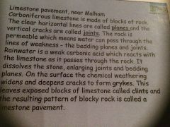
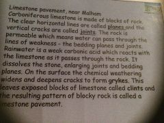
Carboniferous landforms |
Limestone pavements Limestone caves Scar Cavern Stalactite Swallow hole |
|
|
|
How was it formed? |
By the compaction and cementation of sediments, usually deposited in the sea. |
|
|
|
Where is limestone found in the uk |
Above the tees-exe line, North England, Yorkshire dales, Peak District, Cumbria, Pennines, South of grampians, Northern Ireland |
|
|
|
Why Carboniferous limestone produces distinctive landforms: |
Chemical weathering: rain water contains carbon dioxide in solution (carbonic acid). It is a weak acid, it reacts with rocks (Calcium carbonate, limestone) it dissolves it slowly and removed it in solution by running water. Chemical weathering allows the rock to decompose where they are located Rock structure: sedimentary rocks are laid down in layers, each layer is separated by a bedding plane. Joints and bedding planes are areas of weakness which are dissolved and widened by chemical weathering Permeability: Carboniferous limestone is pervious, unlike chalk which is porous. Porous rock consists of many small pores which allow water to pass through it. A pervious rock restricts water flowing along bedding planes and down joints |
|
|
|
Carboniferous landforms |
Limestone pavements Limestone caves Scar Cavern Stalactite Swallow hole |
|
|
Front (Term) |
/ |
|
|
Front (Term) |
: |
|
|
|
Front (Term) |
: |
|
|
|
Front (Term) |
- |
|
|
Front (Term) |
: |
|
|
Front (Term) |
- |
|
|
|
Swallow holes |
Are created on the surface of limestone, they form where there is a joint which has been enlarged and widened by chemical solution, eroded further by streams |
|
|
|
Blocks- clints Gap- gryke Dips- runnels |
|
|
|
|
Limestone uses |
Roads Houses Strong Durable Pure Cosmetics Glass Talcon powder |
|
|
|
Limestone uses |
Roads Houses Strong Durable Pure Cosmetics Glass Talcon powder |
|
|
|
Limestone is calcium based rock permeability |
|
|
|
|
Limestone uses |
Roads Houses Strong Durable Pure Cosmetics Glass Talcon powder |
|
|
|
Limestone is calcium based rock permeability |
|
|
|
|
Water cannot get through impervious rock or surfaces |
|
|
|
|
Limestone uses |
Roads Houses Strong Durable Pure Cosmetics Glass Talcon powder |
|
|
|
Limestone is calcium based rock permeability |
|
|
|
|
Water cannot get through impervious rock or surfaces |
|
|
|
|
Land uses of limestone |
Used to treat soils and purify water Farming- Yorkshire dales, sheep farming 40% of the yd is fields Cattle fed from hay in the valley floors(flat areas) the soils are too thin and they are too dey- only thing that can grow is short grass- sheep like |
|
|
|
Economic uses |
Quarrying- most quarries tend to be found in national parks, 4.5 million tonnes of rock quarried each year in Yorkshire dales, Carboniferous rock. Swindon quarry, infection quarry cement, aggregates, building stone, industry (flocks)
|
|
|
|
Levee |
a levée is a river with a hump of deposited sediment on the top of the bank to protect it from overflowing |
|
|
|
Granite tor |
What's a granite tor? Blocks of rocks outcropping on top of a granite plateau in areas such as dartmoor How high are the tors? Bogs, marsh, moorland, 5-10m high
Found in higher parts to indicate granite rock found beneath this area??? Soil and acidic and infertile, water, boss What sort of scenery is formed by granite in Scotland? Granite peaks What type of rock is granite? Igneous (impermeable)
Why are they so many bogs s found in western upland areas?? High areas with greatest pricipitation |
|
|
|
Weathering |
Breaking up or decay of rocks and it's not moved |
|
|
Front (Term) |
Back (Definition) |
|
|
|
Weathering |
Breaking up or decay of rocks and it's not moved |
|
|
|
Front (Term) |
Back (Definition) |
|
|
|
Front (Term) |
|
|
|
|
Sed Limestone Sandstone Siltstone Shale Chalk
Igneous Basalt granite
Metamorphic Schists Marble |
|
|
|
|
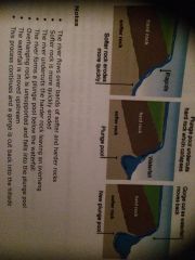
Waterfalls |
1. The river flows over bands of softer and harder rock 2. Softer rock is more quickly eroded 3. The river undercuts the harder rock leaving an overhang and river forms a plunge pool 4. Overhanging rock is unsupported and falls into the plunge pool 5. The waterfall is moved upstream 6.This process continues and a gorge is cut back into the hillside |
|
|
|
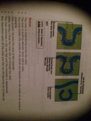
Ox bow lakes |
- the river is meandering across the valley - the river is eroding laterally (from side to side) - the river erodes the outside of the bends and deposits on the inside so it's course is changing - this erosion narrows the neck of the meander - often during a flood - the river continues in the new bed and the meander is left - deposition that's new deals off the ends and cut-off becomes a ox-bow lake |
|
|
|
Waterfalls |
1. The river flows over bands of softer and harder rock 2. Softer rock is more quickly eroded 3. The river undercuts the harder rock leaving an overhang and river forms a plunge pool 4. Overhanging rock is unsupported and falls into the plunge pool 5. The waterfall is moved upstream 6.This process continues and a gorge is cut back into the hillside |
|
|
|
Ox bow lakes |
- the river is meandering across the valley - the river is eroding laterally (from side to side) - the river erodes the outside of the bends and deposits on the inside so it's course is changing - this erosion narrows the neck of the meander - often during a flood - the river continues in the new bed and the meander is left - deposition that's new deals off the ends and cut-off becomes a ox-bow lake |
|
|
|
Levee |
River is on its flood plain with very low gradient, river mainly depositing, when the river floods lots of slit is deposited on the river banks and much less on the flood plain. Frequent flooding continues the build up. The river deposits in the river bed when flowing normally, then the river raises above the floodplain, the built up lump of levees protect the plain from flooding |
|