![]()
![]()
![]()
Use LEFT and RIGHT arrow keys to navigate between flashcards;
Use UP and DOWN arrow keys to flip the card;
H to show hint;
A reads text to speech;
69 Cards in this Set
- Front
- Back
- 3rd side (hint)
|
The population of the Alps |
Around 12 million |
|
|
|
Which countries do the Alps go through? |
Austria, France, Germany, Italy, Liechtenstein, Slovenia and Switzerland |
|
|
|
When and how were the Alps formed? |
30 million years ago by the collision between the European and the African plates |
|
|
|
What can be mined in the Alps? |
Salt, iron ore, gold, silver and copper |
|
|
|
What has happened to the mining industry in the Alps and why? |
It has declined because of cheaper foreign sources |
|
|
|
What is the soil like in the valleys of the Alps? |
Deep and fertile |
|
|
|
How does having mountains help farming? |
They provide shelter from the wind |
|
|
|
What do they farm on valley floors in the Alps and why? |
They farm cattle and goats because the land is flat. Goats can also be found further up on the slopes. |
|
|
|
What has happened on the sunnier slopes (usually south-facing adrêt slopes)? |
They have been terraced for vineyards eg. Lavaux, Switzerland. |
|
|
|
Why is it often difficult to farm the ubac slope (north-facing, wetter, shaded slope)? |
It is often shadowed by mountains so crops sometimes can't get enough sunshine to grow. |
|
|
|
Why are goats popular in the Alps? |
They are well-adapted to the steep slopes so can be farmed further up the mountains. |
|
|
|
Why do some places in the Alps need protecting and how are they protected? |
They need protection from avalanches and land-slides because these can destroy buildings. They use trees and man-made defences to prevent this. |
|
|
|
Why can't you grow crops up the mountains? |
The soil is shallow and infertile on the upper and steep slopes and the land can also be shadowed for most of the day. |
|
|
|
What can people use the upper slopes of the Alps for? |
Grazing animals like goats can replace growing crops in these areas. |
|
|
|
Advantages and disadvantages of tunnels through the Alps? |
Tunnels are much faster than passes but are very expensive to build. Eg. The Lötschberg Base Tunnel cost SFr 4.3 billion or £3 billion but cut journey times between Valais and Bern by 50%. |
|
|
|
Generating HEP |
Narrow valleys in the Alps have been dammed to generate HEP eg. The Berne area valleys. |
|
|
|
Roads in the Alps |
Roads have been built over passes in the Alps (lower points between mountains) like the Brenner Pass between Austria and Italy but it takes a long time to drive over passes and roads are often blocked by snow. |
|
|
|
Using HEP |
The electricity generated by HEP can be either used locally or exported to further away. Switzerland gets 60% of its electricity from HEP. |
|
|
|
What is normally planted on the Alps and why? |
Scots Pine is planted on the Alps because it is more resilient than native saplings which are normally eaten by goats. |
|
|
|
What can be done with the wood from the Alps? |
The scots pine can be logged and sold or made into furniture and then sold. |
|
|
|
How many tourists visit the Alps evry year? |
100 million |
|
|
|
What do most tourists visit the Alps for? |
70% of tourists visit for skiing, snow boarding and ice-climbing in the Winter. |
|
|
|
What other things do tourists visit the Alps for? |
They visit for the scenery, walking, cycling, paragliding and climbing. |
|
|
|
How does the area around the Alps cope with tourists? |
New villages have been built for tourists in the area eg. Tignes, France. Ski runs, ski lifts, cable cars, holiday chalets and restaurants pepper the landscape. |
|
|
|
What is the highest point in the Alps? |
Mont Blanc at 4810m. |
|
|
|
When was the Montserrat eruption? |
Small eruptions began on 18th July 1995 but the big eruption happened on 25th June 1997. |
|
|
|
Montserrat |
Montserrat is a small island in the Carribean. It is 40 sq.mi. and a British colony with a mountain range called the Soufrière Hills to the South. |
|
|
|
Why is Montserrat volcanic? |
It lies on a subduction zone between the continental Caribbean plate and the oceanic North Atlantic plate. |
|
|
|
What happened to cause the Montserrat eruption? |
Magma rose through weak points in the Earth's crust under Chance's Peak creating a pool. The rock above the pool collapsed, creating a vent and causing an eruption. |
|
|
|
Which mountain erupted on Montserrat? |
Chance's Peak, Soufrière Hills. |
|
|
|
How much rock and ash was released from the Montserrat eruption? |
4-5 million cubic metres |
|
|
|
What caused most of the destruction in the Montserrat eruption? |
Pyroclastic flows of up to 85 km/h and ash clouds of up to 130 km/h. |
|
|
|
What are pyroclastic flows? |
Super-heated, fast-moving clouds of gas and ash. |
|
|
|
How much of the island was safe? |
Only 15 sq.mi. were safe. |
|
|
|
What was the Montserrat lava like? |
Viscous (thick), full of gas and acidic. |
|
|
|
Primary effects of the Montserrat eruption? |
●Plymouth was covered in 12m of mud and ash ●Over 20 villages and 2/3 of homes were destroyed by pyroclastic flows ●Vegetation and farmland were devastated ●Schools, hospitals, the airport and the port were obliterated ●2/3 of the island was uninhabitable ●19 people died and 7 were injured |
|
|
|
Secondary impacts of the Montserrat eruption? |
●8,000 of the island's 12,000 inhabitants have left since 1995 ●Fire destroyed many buildibgs including local government buildings, the police headquarters and the city's petrol station ●Tourists stayed away and businesses were destroyed, disrupting the economy ●Volcanic ash caused ling cancer ●Quartz from the eruption caused silicosis ◆Volcanic ash has improved soil fertility ◆Tourism is increasing as people now come to see the volcano |
|
|
|
Short term responses to the Montserrat eruption? |
■5000 people were evacuated to the north ●8,000 people left the island completely ◆Local emergency services helped with search and rescue attempts ◆Temporary roads and electricity supplies were built ◆Shelters were built for the evacuees ◆Charities helped give emergency shelyer, food and schooling ◆The British government gave £17 million |
|
|
|
Long term responses to the Montserrat eruption? |
■A risk map was created and en eclision zone is in place - the South is off-limits while the volcano is still active ■£200 million was spent on water and electricity ●Younger people never returned to the island ◆The UK has provided £41million to develop the North with docks, an airport and houses ◆The Montserrat Volcano Observatory has been set up to predict future eruptions ◆5,000 people have returned to the island |
|
|
|
How big is the Yellowstone caldera? |
Around 40 miles wide |
|
|
|
How does the Yellowstone caldera compare to the surrounding land? |
It is lower |
|
|
|
Where is the Yellowstone caldera? |
Yellowstone National Park, Wyoming |
|
|
|
What shape is the Yellowstone supervolcano? |
A caldera |
|
|
|
What is a caldera? |
A large, bowl-like dip surrounded by the hills of the rim. |
|
|
|
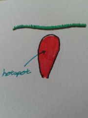
What is the first step of forming the Yellowstone supervolcano? |
A plume of magma called a hotspot fills a magma chamber. |
|
|
|
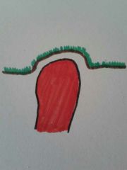
What is the second step of forming the Yellowstone supervolcano? |
The magma chamber expands as it fills up and causes the uplift and deforming of the land above it. |
|
|
|
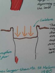
What is the third step in forming a caldera? |
After the eruption, the magma chamber empties very quickly and the overlying land collapses, forming the caldera. |
|
|
|
How big does a volcanic eruption have to be to be classed as a supervolcano? |
It must erupt at least 1000 cubic km of material. It is much larger than any normal volcanic eruption and the Yellowstone eruption is predicted to be at least 10x larger than the 1980 Mt. St. Helens eruption. |
|
|
|
How does a supervolcano like Yellowstone erupt? |
It erupts from many places around the rim lasting for several months. ★Not through a central vent.★ |
|
|
|
What is the evidence for a Yellowstone eruption? |
●There have been three previous eruptions spanning 2.1 million years, each usually 600,000 - 750,000 years apart. The last was 640,000 years ago. ●You can see the layers of ash in old rocks from the previous eruptions. |
|
|
|
What are the impacts of a Yellowstone supereruption? |
●A 1000 mile radius would be immediately wiped out ●This would cause the instant death of 100 million+ North Americans ●There would be a 20+foot layer of ash over 2/3 of the USA ●Sunlight would be globally blocked out for at least 2 years within weeks |
|
|
|
What would be the impacts of global sunlight being blocked after a Yellowstone supereruption? |
●Vegetation would be unable to grow ●Mass starvation due to lack of food ●Mass extinction due to starvation ●Global economy collapse ●No transport or communication links ●The priority would become survival ●It could cause a volcanic winter |
|
|
|
What would a Yellowstone volcanic winter be like? |
The global temperatures could drop by up to 7°C and it could trigger a mini ice age. |
|
|
|
Where is Kobe? |
In southern Japan |
|
|
|
When did the Kobe earthquake happen? |
16th January 1995 at 5:46am |
|
|
|
Why did the Kobe earthquake happen? |
Kobe lies on the fault line between the Philippine and Southern Japan plates. |
|
|
|
How strong was the Kobe earthquake? |
7.2 on the Richter scale |
|
|
|
Primary impacts of the Kobe earthquake? |
■5,500 people died ■30,000 people were injured ■200,000 buildings collapsed, 100,000 of which were homes ■130 km of expressway had to close ■Over 250,000 telephone lines were damaged ■Over 300 fires started from damaged gas mains killing 5000 people ■Kobe's port had to close stopping 30% of Japan's trade |
|
|
|
Secondary impacts of the Kobe earthquake? |
■62 high rise buildings had to be demolished ■300,000 purple were evacuated and made homeless ■Companies had to close costing 20,000 jobs ■Re-construction cost $120 billion ◆New jobs were created to rebuild Kobe |
|
|
|
Short term responses to the Kobe earthquake? |
◆The emergency services went to help ■They were poorly equipped and unprepared ◆300,000 people were evacuated |
|
|
|
Long term responses to the Kobe earthquake? |
■The Japanese government responded slowly ◆Wider roads were built ◆ They introduced more open spaces ◆Buildings were built stronger with flexible frames, out of fire resistant materials and on the most solid ground ◆Monitoring equipment on the Southern coast was increased |
|
|
|
Where is Kashmir and when was the natural disaster that happened there? |
Kashmir is in Northern Pakistan and the earthquake happened in 2005. |
|
|
|
When did the Kashmir earthquake happen? |
8th October 2005 at 8:40am. |
|
|
|
Why did the Kashmir earthquake happen? |
Kashmir lies on the collision zone between the Indian and the Eurasian plates. |
|
|
|
How strong was the Kashmir earthquake and why was it particularly devastating? |
It was 7.6 on the Richter scale and millions of children were in schools that were poorly built because it was a Saturday morning. |
|
|
|
Primary impacts of the Kashmir earthquake? |
■79,000 people died ■Hundreds of thousands of people were injured ■ 3.5 million homes were destroyed ■800 hospitals were devastated ■Water pipelines and electricity lines were broken, cutting off supply. |
|
|
|
Secondary impacts of the Kashmir earthquake? |
■Landslides buried people and buildings ■Diseases like diarrhoea spread through dirty water ■3.5 million people lived in temporary accommodation ■The freezing winter conditions afterwards caused more casualties and hindered the rescue and rebuilding operations ■$5 billion was spent to rebuild the area |
|
|
|
Short term responses to the Kashmir earthquake? |
■Help didn't reach many areas for weeks ◆Tents were given out by armies and Muslim Aid ◆Local people rescued those who were trapped ◆Military hospitals were opened to civilians ◆The Red Crescent distributed 21,500 blankets, 300 kitchen sets and medical supplies ◆Rescue and medical teams arrived from other countries ◆Emergency services came to help ◆Military helicopters took the injured to hospitals ◆Foreign governments gave $6.2 billion ◆ Pakistan Airways transported emergency supplies for free |
|
|
|
Long term responses to the Kashmir earthquake? |
◆Water supplies were re-established ◆The army and Red Crescent built homes from corrugated iron for the winter ◆Schools were rebuilt stronger ◆40,000 people have been relocated from the destroyed town of Balakot ◆New building laws have been introduced to make buildings more earthquake-proof ◆New health centres were set up in the area ◆The ERRA (Earthquake Reconstruction and Rehabilitation Authority) was created to rebuild destroyed buildings better than they were before they were destroyed. |
|