![]()
![]()
![]()
Use LEFT and RIGHT arrow keys to navigate between flashcards;
Use UP and DOWN arrow keys to flip the card;
H to show hint;
A reads text to speech;
287 Cards in this Set
- Front
- Back
|
Paved vehicular circulation (parking, drives - not the entry- , loading spaces etc.) should be at least ___ from any street right-of-way (property line along a street), and at least ___ from any other property line. |
4.5m (15') 3.0m (10')
|
|
|
All buildings shall be set back at least ___ from any street right-of-way (property line along a street), and at least ___ from all other property lines. |
7.5m (25') 4.5m (15') |
|
|
All development requiring site disturbance shall be set back at least ___ from any designated stream edge or other water body. What are the exemptions? |
15m (50') Activities that require direct water access are permitted (boat docks, boat ramps, etc.)
|
|
|
All development requiring site disturbance shall be set back at least ___ from the edge of any designated wetland. |
30m (100') |
|
|
What is not permitted within a floodplain? |
Enclosed structures and their appurtenances. |
|
|
Define incompatible use. |
An incompatible use is where there is proposed commercial and an adjacent parcel zoned residential. Institutional used such as schools, libraries, churches, hospitals and daycare facilities are exempt. |
|
|
There shall be a ___ setback provided from any property line where there is an incompatible use. |
7.5m (25') |
|
|
The area within an incompatible use setback shall not be utilized for what? |
Structures, roads, and parking areas or for any active recreation purpose such as tennis courts, swimming pools, playgrounds or uses of a similar nature. |
|
|
There shall be a ___ clear zone, free of obstructions, around active recreational uses such as football, soccer, baseball, volleyball, basketball or uses of a similar nature. |
9m (30') |
|
|
What should not be located within an Active Recreation Setback? |
Pedestrian or vehicular circulation. (unless providing direct access to the recreation use). |
|
|
When are guardrails required? |
On retaining walls where differences in grade level on either side of the wall are in excess of 0.75m (2.5') and are located closer than 1.0m (3') to a walk, path, parking lot or driveway on the high side. |
|
|
How tall should Handrails be? How tall should guardrails be?
|
30"-34"
Minimum of 1.1m (42") in height measured from the leading edge of a stair tread or adjacent surface. |
|
|
Open guardrails must have what? |
Balusters or other construction such that a sphere with a diameter of 100mm (4") cannot pass through. |
|
|
Which way should a baseball/softball field be oriented? |
East-northeast from home plate to centre field. |
|
|
Which was should a football/soccer field be oriented? |
Long axis north-south |
|
|
Which way should a tennis/basketball/volleyball court be oriented? |
Long axis north-south |
|
|
Which way should passive and active solar systems be located? |
South-southeast to South-southwest |
|
|
What is the maximum length for a cul-de-sac? |
240m (800') |
|
|
Parking shall not back in what? |
Primary circulation or entrances. |
|
|
Vehicular circulation used solely for ____________ is not considered primary circulation. |
Parking lot ingress/egress. |
|
|
Vehicular circulation entrances must be directly aligned or offset a minimum of ___. |
23m (75') |
|
|
Two-way vehicular circulation shall be a minimum of ___. |
8.0m (26') |
|
|
One-way vehicular circulation shall be a minimum of ___. |
3.3m (11') |
|
|
The minimum inside turning radius for automobiles shall be ___. |
5.5m (18') |
|
|
The minimum inside turning radius for large vehicles (such as trucks, buses, and emergency vehicles) shall be ___. |
9.1m (30') |
|
|
The dimension for a standard parking space shall be __________. |
2.7m x 6.0m (9' x 20') |
|
|
The minimum aisle width for a parking lot shall be ___. |
6.0m (20') |
|
|
Parallel parking spaces shall have a minimum length of ___ and a minimum width of ___. |
Length 6.7m (22') 2.7m (9') |
|
|
Open off-street parking areas with more than 40 spaces shall have a maximum of ___ contiguous spaces without an island. Minimum width of a parking island shall be ___. |
Max 10 spaces 2.7m (9') wide island |
|
|
Parking areas must be graded at a slope not to exceed ___. |
5% |
|
|
What is not permitted in parking area design? |
Dead end parking areas. |
|
|
The dimension of a standard bus loading/unloading space shall be _________. |
3.6m x 14m (12' x 45') |
|
|
For all uses with a drive-up window (restaurants, banks, etc) and for all uses involving customers waiting in line while in their vehicles (car washes, fast-food, etc), in addition to the standard parking space requirements, stacking spaces for at least ___ vehicles, including the vehicle at the window, shall be provided for one window or unit. ___ additional spaces shall be provided for each additional window or unit thereafter. |
6 stacking units 2 additional stacking units |
|
|
For all uses with an unattended drop box (mail, book, video, etc), in addition to the standard parking space requirements, stacking spaces for drop boxes shall allow space for ___ vehicles at the box. |
2 |
|
|
Stacking spaces shall be located to allow for traffic movement around stopped vehicles to avoid stacked vehicles overflowing onto primary circulation. The width of a drive through travel lane shall not be less than ___. |
3.3m (11') |
|
|
A stacking space shall have a minimum length of ___. |
5.5m (15') |
|
|
If a drop-off/pick-up area is provide, it shall be designed to allow for what? |
The safe movement of vehicles and pedestrians. It shall also be designed to allow for traffic movement around stopped vehicles. |
|
|
Drop-off/pick-up areas shall have a minimum length of ___ per vehicle and a minimum width of ___. |
6.7m (22') per vehicle 2.7m (9') |
|
|
Service areas shall incorporate a minimum ___ turnaround to accommodate small service vehicles (such as panel vans). |
6.0m (20') |
|
|
If parking spaces are provided for self parking by employees or visitors, or both, then accessible spaces shall be provided in each such parking area in conformance with what standards? |
1 space for between 1-25 spots 2 / 26-50 3 / 51-75 4 / 76-100 5 / 101-150 6 / 151-200 7 / 201-300 8 / 301-400 9 / 401-500 2% of total / 501-1000 20 plus 1 for each 100 over 1000 |
|
|
Where should high density uses be located? |
Near existing roads for ease of access. |
|
|
Slopes under 5% make construction_____? |
Easier! |
|
|
Provide _______ between commercial and residential. |
Buffer |
|
|
Locate high density uses on slopes of less than ____? |
5% |
|
|
Locate medium density uses on slopes of ___ to ___? |
5-10% |
|
|
What would be the only reason to removing existing vegetation? |
In order to solve an important HSW issue. |
|
|
What uses should take advantage of street frontage? |
Commercial |
|
|
What type of drop-off layout impedes traffic flow? |
One-lane. Allow for two-lanes when possible. |
|
|
What should be controlled in the winter? |
Wind (from the East and West) |
|
|
What should be controlled in the summer? |
Sun |
|
|
Winter patio (2 orientation attributes): |
- shelter from North, Northeast - face South |
|
|
The landform that most greatly affects microclimate is: |
slope and aspect/orientation |
|
|
Drop-off loops should flow: |
counter-clockwise to passenger exits to the sidewalk |
|
|
Intersections should meet at: |
90 degrees |
|
|
What are the measurements of the cone of vision? |
Vertical: 30 degrees Horizontal: 60 degrees |
|
|
Minimum width for a private stairway?
Minimum width for a public stairway? |
42" 60"
|
|
|
Tread riser ratio (or formula)?
Range for riser height? |
2 * Riser+Tread = 26 to 27"
4.5 to 6"
|
|
|
General rules for stairs: |
- No single steps (at least 2, preferably 3) - Mark stairs with handrail, lights, stripes, etc. - Pitch tread 2% downward for drainage
|
|
|
Height between stair landings? |
Vertical distance (5') |
|
|
Minimum widths for one and two-way wheelchair ramps? |
One-way: 0.90m (3') Two-way: 1.50m (5') |
|
|
Max slope of wheelchair ramps?
Curb cuts max slope? |
1:12 (8.33)
1:8 (12%) |
|
|
Distance between landings on wheelchair ramps? |
9.0m (30') |
|
|
Maximum height of a wall before an engineer has to sign off on it? |
0.75m (2.5') |
|
|
Elevation determines what 2 integral things? |
1. General drainage pattern and extent of watersheds
2. Viewsheds |
|
|
What types of soils are to be avoided when siting buildings? |
Poorly drained and wetland soils. Soils must have adequate load bearing capacity. |
|
|
What types of soils are prone to erosion in steep slopes? |
Sandy or loose soils. May require mitigating design measures. |
|
|
What does the presence of bedrock pose potential limitations for? |
Grading, drainage, and for siting structures and ball fields (require drainage). |
|
|
Considerations for microclimate include the following: |
- orientation to sun and shade - passive solar design - minimizing heat gain in hot and humid climates - use evergreen windbreaks, shade trees, and deciduous trees for passive solar design, buffering north winds, or encouraging ventilation |
|
|
Hydrologic characteristics are important in particular when dealing with: |
- depth to groundwater - drainage - surface water - seasonal variations |
|
|
Sight line triangles at intersections |
- 45' x 45' from point where curb lines intersect on roadway - objects within these triangles, such as shrubs and groundcovers, have height limitations of 2'
|
|
|
When to screen views with planting? |
- parking lots and roadways adjacent to residential uses, walks, or trails - incompatible uses
|
|
|
Max. slope for a walk is ___. |
5% Anything greater is considered a ramp |
|
|
Minimum width of an accessible route is ___? |
3' (0.9m) except at doors |
|
|
What percentage of public entrances must be accessible? |
50% Including at least one ground floor entrance |
|
|
Max. slope of a ramp? |
12:1 (8.33%) |
|
|
Where should ramp landings be located? |
Top + bottom of ramp At each ramp run
Landing shall be at least as wide as the run that leads to it.
Landing shall measure at least 5'x5' (1.5mx1.5m) |
|
|
Ramp landings are required when?
|
When vertical rise reaches 2.5' (0.8m)
|
|
|
Ramp min. length? |
5' (1.5m) 3' |
|
|
Porosity (of soil) |
Amount of pore space in a soil (related to grain size) |
|
|
Permeability (of soil) |
Rate at which water will freely drain through a soil. Ex: clay soils usually have high porosity, but low permeability. May settle considerably when loaded with a foundation, but they have lower compressibility and high strength. |
|
|
Soil strength |
Soil's ability to resist deformation (a function of friction and cohesion). |
|
|
Cohesion |
Measure of the capacity of soil particles to stick together. High cohesion is mostly associated with clays. |
|
|
Shear strength |
Measure of the frictional resistance and cohesion of a soil. |
|
|
Bulk Density |
Refers to the weight per volume of any unit of soil. Rule of thumb: higher bulk density = greater support for foundations |
|
|
Liquid limit |
Moisture content at which a soil tends to flow and will not retain its shape. |
|
|
Plastic Limit |
Moisture content at which a soil deforms plastically. Soil is rolled into threads until it crumbles. |
|
|
Soil Types |
Clay - C Silts - M Sands - S Gravels - G Organic - O High Liquid Limit - H Low Liquid Limit - L Well Graded - W Poorly Graded - P |
|
|
Incandescent lighting (pros and cons) |
Colour rendition Warm white Short life |
|
|
Fluorescent lighting (pros and cons) |
Colour rendition Long life Glare Poor optical control |
|
|
Mercury vapor lighting (pros and cons) |
Good for lighting foliage Affordable Long life Exposure can risk health |
|
|
Metal halide lighting (pros and cons) |
Colour rendition Optical control Short life |
|
|
High pressure sodium lighting (pros and cons) |
Low maintenance Good optical control Poor colour rendition |
|
|
Low pressure sodium (pros and cons) |
Longest life Poor colour rendition Poor optical control |
|
|
Tips to ensure uniform lighting: |
1. Select which light is most appropriate (i.e. area, bollard, down, low down, or accent) 2. Confirm radius size of one footcandle 3. Ensure no dark spots between lights |
|
|
Planting design in terms of physical environment? |
- soil - sunlight / solar exposure - precipitation - wind exposure - seasonal temp range - salt tolerance (if applicable) |
|
|
Planting design in terms of design requirements? |
- directing movement - framing vistas - moderating site environment - creating spaces / defining the base, vertical and overhead plane
|
|
|
Planting design in terms of design character of the plant material? |
- height - mass - form (rounded versus columnar) - color - seasonal interest - growth habits |
|
|
When a lighted object can be seen from one direction only, above-grade accent lights can be used. Prevent glare by aiming fixtures away from observers.
|
Uplighting for Directional Viewing |
|
|
If the lighted object can be seen from any direction, then well lights with louvers should be considered.
|
Uplighting for All Around Viewing |
|
|
Up and down lighting is used to create this effect. Ground lighting is accented by shadows from leaves and branches.
|
Moonlighting |
|
|
Trees and shrubs with interesting branching structure can be dramatically expressed with this technique. This also provides additional security near buildings. |
Silhouette Lighting |
|
|
Special objects such as statues, sculpture, etc can be lighted with well shielded fixtures with this technique. |
Spotlighting |
|
|
This type of lighting produces circular patterns of illumination for general area lighting. Effective for groundcovers, low shrubs, walks, and steps. |
Spreadlighting |
|
|
Induction Lamps
|
No filaments |
|
|
Pros and cons of straw mulch: |
available absorbent biodegradable Anchored in place (costly) Requires nets/tackifier (costly) Fire hazard |
|
|
Pros and cons of wood fiber mulch:
|
Low cost Available Does not resist erosion or protect from rainfall |
|
|
Pros and cons of netting/fibre mulch
|
Protects from rainfall Absorbs water Holds moisture Good slope protection Costly Install must be in contact w/ soil |
|
|
7 common causes of slope failure
|
2. Increasing fill on slope w/out adequate drainage 3. Removing vegetation 4. Increasing slope grade 5. Increasing slope length by cutting at bottom of slope 6. Changing surface drainage route 7. Changing subsurface drainage route |
|
|
Hard, dense stone. Difficult to work with. Weather resistant, durable.
|
Granite |
|
|
Wide colour range, durable stone, easy to work with stone. |
Limestone |
|
|
Durable stone, range of colours, earth tones, similar to limestone in workability.
|
Sandstone |
|
|
Durable stone, moderate to expensive, slippery when wet.
|
Flagstone
|
|
|
Durable stone, expensive, slippery when wet.
|
Slate |
|
|
Grade of brick which is resistant to freeze/thaw. Can be used as paving. Costly.
|
Sx grade
|
|
|
Grade of brick not recommended in zones which will be saturated w/ water.
|
Mx grade |
|
|
Installed in light duty (2 layers) to heavy duty (+/- 5 layers). Inexpensive and durable. Absorbs heat. |
Asphalt |
|
|
Versatile and durable. Commonly used as paving material. Good life cycle costs. Options for colour and texture. |
Concrete |
|
|
Rational Method formula for calculating peak discharge rates of stormwater
|
Q= peak discharge (cubic feet per second) C= run off coefficient (ratio of amount of surface runoff to rainfall) i= rainfall intensity for a storm duration equal to the time of concentration A= area of the basin (or subshed |
|
|
Site analysis: LC T HD S M V E O U V SS S |
Location and Context Topography Hydrology and Drainage Soil Microclimate Vegetation Existing Buildings Other Structures (ex.) Utilities Views Spaces and Senses Site Functions |
|
|
What is an open propietary specification? |
A spec that permits the use of approved substitutions and also allows for competition between bidders. |
|
|
What type of spec designates certain product by brand name, model number or manufacturer's info? |
Proprietary spec |
|
|
What type of spec makes reference to an existing industry standard? |
Reference Spec |
|
|
What are complete streets? |
Streets designed and operated to enable safe access for ALL users. (Cars + Peds + Bikes) |
|
|
What might be included as an approach for roadways that are designed using Complete Streets methods? |
A. Rural roads w/ Shared use trails D. Shared commercial streets E. Bus-only lanes F. Traffic circles H. Angled head-out parking I. Neighborhood Greenways |
|
|
What type of spec describes the end result and places more responsibility on the contractor? |
Performance Spec |
|
|
What type of spec describes materials and methods of construction and places more responsibility on the designer? |
Descriptive/Prescriptive/Design |
|
|
What type of bedrock is Alkaline? |
Limestone |
|
|
What types of bedrock are acidic? |
Granite |
|
|
Elements of a Base Map |
Items on a Base Map: -Existing Conditions |
|
|
Parking Orientation Efficiency |
Cars parked perpendicular to the travel aisle yields the most efficient number of cars per acre since it requires less space. The least efficient parking result from 30 degree angle layouts, which are typically used only when their is insufficient lateral dimensions for other options. (TSS, page 210-8) |
|
|
Littoral Zones |
Part of a sea or lake that is adjacent to shore. |
|
|
Hydric Soils |
Soil characterized by wet conditions or saturation most of the year; often organic in composition. (LaGro) |
|
|
Floor Area Ration (FAR) |
A buildings total floor area divided by the total building parcel area or lot area. Some municipalities state that the Floor-to-Area ratio is the maximum buildable area on a site. |
|
|
Project Program |
4 steps 1. Initiate the Project 2. Develop the project's mission and objectives 3. Determine the project's operational and physical requirements 4. Document and present the program to the client(LaGro) |
|
|
What is embodied energy? |
The sum of energy required to produce any good or service, considered as if that energy was incorporated in the product itself. Useful in determining the effectiveness of energy-producing or energy-saving devices, or the "real" replacement cost of a building, and, because energy-inputs usually entail greenhouse gas emissions, in deciding whether a product contributes to or mitigates global warming. |
|
|
Section Elevation Section Elevation |
Section - is vertical surface made by a cut. It's basically a thick/heavy line, no graphics behind it. Elevation - the elements beyond a section, when drawn to scale, form an elevation. no cut line is shown in an elevation. Section Elevation - Section is the line, elevation is what is behind the line, hence section elevation. |
|
|
Vehicular Circulation 3 operating characteristics that influence roadway design ? |
1. Turning radius 2. Acceleration 3. braking distance (TSS, p.342-9) |
|
|
DEVELOPING MASTER PLAN DOCUMENTS What drawings are contained in a preliminary site plan? |
-Written site inventory and analysis (such as a list of attributes and analysis) -Survey Plan -Schematic/Master Plan/Landscape Plan -Lighting Plan -Building Renderings (sketches, sections, elevations - need to know the fenestration of the building (arrangement of windows/doors), what it looks like -Road/Street Signage Plan (avoid any potential vehicular/pedestrian hazards) |
|
|
CONCEPT DEVELOPMENT What are the colors for land use mapping? |
YELLOWS - residential (single-family/town houses) BROWNS - multi-family and high-rise residential REDS - retail and commercial uses PURPLES - industrial uses BLUES - institutional and public facilities GREENS - recreational uses Grays - industrial / utilities |
|
|
IRRIGATION DESIGN What are the disadvantages of drip irrigation? |
- filters within system are required to prevent clogging - adaptation can be more involved than spray sprinkler irrigation - 1st indication of maintenance problems should up when plants are stressed. |
|
|
IRRIGATION DESIGN What are the advantages of drip irrigation? |
- precise placement of water - reduced weed growth - high water use efficiency - evaporation and run-off minimized - flexible operating hours compared to spray sprinklers which should be applied only in early morning (less wind throw at that time) - add emitters at any time if more plants added |
|
|
IRRIGATION DESIGN What are the general guidelines to sprinkler layout design? |
- lay out sprinklers on perimeter of area first, then work towards interior - TSS suggests square locations for sprinklers, other sources suggest equilateral triangles - consider wind (especially on large open areas) - sprinkler over spray onto a hard surface should be avoided. |
|
|
IRRIGATION DESIGN What is the correct precipitation rate/coverage? |
- All sprinklers overlay 100% for even coverage. - know the infiltration rate of soil - idea is to water to below saturation point without causing unnecessary run-off. - 1/4 and 1/2 arc sprinklers are grouped together on a separate lateral to full-arcs laterals because of precipitation rate differences. |
|
|
IRRIGATION DESIGN What are the 2 broad categories of sprinklers used in landscape irrigation? |
1. Pop-up Spray Sprinklers - suitable for small and irregular areas - water pressure causes the stem of the sprinkler to pop up 2. Pop-up Rotor Sprinklers - suitable for large areas and golf/sports areas |
|
|
EARTHWORK What is swell? shrinkage? |
Swell - when soil is excavated, tightly compacted particles break apart and air pockets form between them, resulting in an increase in apparent volume of earth. (Gravel and rock will swell more than clay and will not compact again to their original volume) Shrinkage - when soil is transported and placed in a new location, some particles are lost in the transition. The amount of transported soil compacts to fill a smaller volume than the space from which it originally came. To compensate for this, a shrinkage factor is applied to the final cut and fill calcs. An additional 5-10% is commonly added to the fill qty required. |
|
|
RETAINING WALLS Failure of retaining walls is due to 3 types of forces. What are they? |
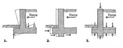
1. Overturning 2. Sliding 3. Settling |
|
|
PLAYGROUNDS What surface materials are appropriate to use for playgrounds and/or tested by ASTM F1292? |
Appropriate playground surfacing materials: • Any material tested to ASTM F1292, including unitary surfaces, engineered wood fiber, etc. • Pea gravel • Sand • Shredded/recycled rubber mulch • Wood mulch (not CCA-treated) • Wood chips Inappropriate playground surfacing materials: • Asphalt • Carpet not tested to ASTM F1292 • Concrete • Dirt • Grass/Turf • CCA treated wood mulch |
|
|
PLAYGROUNDS Should playgrounds intended to serve children of all ages be designed to show the distinct areas for different age groups? |
Yes. The playground designer should recognize that since child development is fluid, parents and caregivers may select a playground slightly above or slightly below their child's abilities, especially for children at or near a cut-off age (e.g., 2-years old and 5-years old). This could be for ease of supervising multiple children, mis-perceptions about the hazards a playground may pose to children of a different age, advanced development of a child, or other reasons. |
|
|
SITE PLANNING What are Transit Orientated Development planning policies? |
Policies are nontraditional General plans - develop concept of mixed use Zoning ordinances - overlay mixed use from traditional neighborhood zones Urban design - promote pedestrian friendly streets with attractive store fronts Parking policies - TOD areas operational costs are paid for by parking lot fees from car users. |
|
|
SITE PLANNING TOD What is a "transit village"? |
The goal is to walk to public transportation instead of using the car within 1/4 mile.It consists of 3 concentric zones Zone A - transit hub - transit station with nearby retail catering to people who are going back and forth from station. Medium to high land use commercial and residential density. Zone B - primary area - walkable area within 1/4 mile with residential and retail use. "Traffic calmed" streets with medium density Zone C - secondary area - within 1/4 to 1/2 mile. (up to 20 min walk). More auto friendly. Housing density low to medium with institutional blgs (schools) |
|
|
SITE PLANNING What is Transit-oriented development? |
TOD is a form of PUD that takes advantage of convenient access to public transportation. This is in direct response to the growing environmental costs to vehicle orientated suburban development (urban sprawl). The most complete form is the "transit-village" - a mixed-use urban community organized around "walkability" concentrated around 1/4 mile (5-10 min walk) within a transit station. |
|
|
AUTOMOBILE CIRCULATION Sight line and vision clearances |
Sight line should be clear of planting between 2'-6" - 7' (see graphic) Trees and low shrubs define area but allow visibility between shrub and tree canopy. Fences should act as a barrier while still allowing for visibility (porous) |
|
|
CPTED What is the general CPTED goal for designers? |
Goal for LA's is to minimize fortress design and target hardening, except where required AFTER thorough analysis and study. The design professional must address the issue of how architectural design features and approaches can enhance security without intruding on the aesthetics and functionality of the building. CPTED security design process is applied from macro to micro level: site security, building perimeter, and inner building space or point protection. |
|
|
CPTED What are the 3 strategies for defensible space design? |
1-TERRITORY: where users develop a sense of territorial control. Established by drawing distinctions b/w spaces such as textural changes in pavements or walls, features that define property lines, elevation changes (step up or down), barriers (walls, fences), visual barriers (low fences, shrubs), or psychological barriers (consistent neighborhood organization or themes) 2- ACCESS: this involves decreasing opportunities for crime by denying access to crime targets and creating a perception of risk for offenders. Street blocking is NOT a preferred method. Better alternatives are designing streets, sidewalks, bldg entrances, neighborhood gateways to mark public routes, structural elements to discourage access to private areas, intersection narrowing, "s" curves in streets, dual use streets, traffic calming measures, one way streets, turn restrictions, and bollards. "Target hardening" is restricting physical access and involves installing fences and gates or other restrictions. 3-SURVEILLANCE: refers to seeing and being seen. Windows, doors facing the street allow people to be seen both as observers and the observed (porches, playgrounds, lighting). |
|
|
CPTED Designing for defensible space |
A "movement predictor" is an unchangeable route/path - offers no choice to pedestrians, and should be avoided. Dangerous, as an attacker can predict where a person will end up once he or she is on the path, and can lie in wait. Closely tied to this is "visual permeability", or the ability to see what is ahead and around, allowing the pedestrian to make a reasonable choice of routes. Good sightlines mean that users are visible to others who can come to their assistance. It is important that barriers delineate boundaries and define circulation, yet at the same time allow users to see and be seen. |
|
|
SITE PLANNING What are the social objectives of TND (Traditional Neighborhood Development)? |
- provide the elderly/youth daily activities within walking distance - minimize traffic congestion - make public transportation a viable alt. - provide citizens a familiar and safe place - integrate all social and economic classes within neighborhood. |
|
|
SITE PLANNING What are the characteristics of TND? |
1. Area limited to a 10 minute walk 2. Residences, shops, workplaces and civic blgs in close proximity 3. Streets share cars and pedestrians equally 4. Parks and squares provide social gathering spaces and recreation 5. High density residential blgs generally occupy central area combined with shops, whereas low residential blgs occupy the outer edge of neighborhood 6. Civic blgs gives the neighborhood an identity. |
|
|
SITE PLANNING What is Traditional Neighborhood Design? |
TND produces compact, mixed use, pedestrian friendly communities. |
|
|
SITE PLANNING THE TOWN PLANNING PROCESS How are the program strategies developed? |
Thru background research, citizen input and site analysis combined with client input. |
|
|
SITE PLANNING THE TOWN PLANNING PROCESS What Local Planning information must be collected and analyzed? |
1. Planning documents - comp plans on land use 2. Urban Design plans - some communities have already developed a design concept 3. Zoning - intensity and type of land use. new development may require a zoning change 4. Public Works (existing Municipal Road layout affect design), public services (local water use) and utilities (sewer). |
|
|
SITE PLANNING TOWN PLANNING PROCESS COMMUNITY INVOLVEMENT What is a "charrette" ? |
A participatory planning/design process with a limited time frame |
|
|
SITE PLANNING The Town Planning Process |
1. Client Contact & Input 2. Literature review 3. Community involvement 4. Regional, State & Federal planning 5. Local Planning Information 6. Site analysis 7. Program development 8. Alternative Plan development 9. Public review 10. Final Design Plans |
|
|
SITE PLANNING What are the urban/city design considerations in terms of context? |
1. Building hierarchy - consider when adding a new building to an existing urban area its hierarchy For instance, public/civic blgs are dominant in placement and design, while residential homes are sub-dominant. 2. Regional character - architectural character should relate to regional landscape character 3. City form - sites with central city squares reserved for important public blgs |
|
|
SITE PLANNING URBAN/DOWNTOWN SITE ANALYSIS What are the environmental considerations? |
1. Air movement - between high rise buildings - create air turbulants - can mitigate prevailing breezes for balconies 2. Sun & shadow patterns - to be considered for internal heat gain and loss 3. Reflections - glare from windows |
|
|
SUSTAINABLE SITE DESIGN: MATERIALS What is embodied energy? Which materials have higher embodied energy? lower embodied energy? |
Embodied energy is the total energy required to produce and install a material or product during all stages of the life cycle. The life-cycle stages include: raw material extraction, processing, manufacture, fabrication, transport, installation, use and maintenance, and recycling or disposal. (complex products made of multiple materials would include the energy inputs from each material component) This does not, however, take into account pollutants produced, toxins released, resources used, or habitats destroyed. High Embodied Energy = Plastic, Metal Low Embodied Energy = Stone, Wood |
|
|
SUSTAINABLE SITE DESIGN: MATERIALS Rapidly renewable materials |
-Primarily plants that are harvested in cycles shorter than 10 years -Coir and Jute are used for geotextiles -Succulents are used as stabilizers for loose aggregate paving -Plant oils are used in form release agents |
|
|
SUSTAINABLE SITE DESIGN: MATERIALS What is the most common building material that is renewable and is considered to be a "long-cycle" renewable material? |
Wood |
|
|
PLANTING Dark green foliage provides... whereasLight green foliage provides... |
Dark green foliage provides...quiet, peaceful, and "moves toward the viewer" whereas, Light green foliage provides...an ethereal, airy quality to a space and "move away from the viewer" |
|
|
LIGHTING TERMS
REFLECTANCE LUMINANCE |
ILLUMINANCE - the amount of direct light falling on a surface, measured with a light meter REFLECTANCE - the amount of light reflected from an object, as compared to the direct light on an object, and varies for different colors. (Paint manufacturers can provide information on reflectance percentage for different colors.) LUMINANCE - the light reflected from a surface or object; it is a function of both illuminance and reflectance and can be calculated with a formula (luminance = illuminance x reflectance/π) |
|
|
LIGHTING |
1-Object Detection, the amount of illuminance required for adequate visibility of objects such as curbs and wheel stops. 2-Crime Deterrence, the amount of illuminance required to make out the facial characteristics of potential perpetrators of crimes. |
|
|
FIRE & WATERSHED SAFETY Fire Retardant Conduction Convection Radiation Hydrophobic Plant Succession |
FIRE RETARDANT- the differences in fuel volume, inherent flammability characteristics of a plant, and the ease of fire spread. CONDUCTION - direct transfer of heat by objects touching each other. CONVECTION - transfer of heat by atmospheric currents. RADIATION - transfer of heat by electromagnetic waves and can travel against the forces of wind. HYDROPHOBIC - the water-repellent characteristic of certain soils; fires can cause soils to become hydrophobic leading the decreased infiltration and increased runoff, thus influencing the amount of potential erosion. PLANT SUCCESSION - a unidirectional change in the composition of a plant ecosystem; it is a result of plants responding to and modifying the environment. |
|
|
PLANTING What are some functional design aspects of plant material? (try to list 6) |
1 - Directing Views 2 - Directing Movement 3 - Spatial Definition 4 - Screening 5 - Physical Control (includes barrier planting and prevention of erosion) 6 - Climate Control (primarily for controlling effects of solar radiation and controlling wind-see graphic for wind) |
|
|
STEPS/STAIRWAYS |
Pedestrians generally prefer risers no lessthan 4-1/2" and no greater than 7" on outdoor stairways. |
|
|
SPATIAL ENCLOSURE |
When vertical planes are one half to one thirdthe width of the space. Ratios greater than these result in spaces that are imposing and shouldnot be used when pedestrians are going to remain for an extended length of time. Ratios less than these result in spaces that lack a sense of enclosure. See graphic. |
|
|
PARKING (Volumes) |
Local code requirements. |
|
|
AUTOMOBILE CIRCULATION |
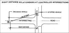
Sight Triangle is the term used to describethe area of oncoming traffic on an intersecting roadway that should be clearlyvisible to a driver stopped at the intersection. See graphic attachment. |
|
|
AUTOMOBILE CIRCULATION |
Sight Distance is the length of road clearlyvisible to a driver. This is based on the eye height of an average driverseated in a passenger car being 3'-9" above the road surface. One shouldprovide minimum sight distance to allow a driver traveling approximately thedesign speed or speed limit to stop before reaching the object sighted. Design Speed to Ttl Stopping Distance 30 MPH ~ 200' 40 MPH ~ 275' 50 MPH ~ 375' 60 MPH ~ 500' |
|
|
RECREATION FIELDS, TSS sect. 520 What are the 5 general concepts in facility design? |
1) Safety and Security 2) Provision for Elderly and Handicapped 3) Maintenance, Operations, and Inspections 4) Parking: common to provide 1 space for every 3 users 5) Signage |
|
|
RECREATION FIELDS, TSS sect. 520List showing acreage needed for most common fields. |
Sport: Acreage Golf:140-175 Baseball: 3.27 Soccer: 2.22 Softball: 2.2 Lacross: 1.99 Football: 1.55 Field Hockey: 1.2 Tennis: .9 Basketball .9 Volleyball: .13 |
|
|
SOUND CONTROL, TSS sect 660 What 3 design elements should be considered when designing a noisebarrier? |
1) Planes: can provoke feelings of excessiveenclosure. Break up the planes by providing a combination of vertical andhorizontal lines, a variety of material, and interest in surrounding landscape 2) Mass: Too much mass can causeclaustrophobia, etc. Instead use stepped walls, staggered alignments, etc. 3) Texture: Coarse texture is preferred. A fine texture (metal) causesreflective light and boredom etc. |
|
|
SOUND CONTROL, TSS sect 660 What 3 design principles are taken into consideration in order toachieve the functional requirements and aesthetic preferences of all who areaffected by noise? |
1) Acoustic effectiveness 2) Economic feasibility 3) Visual attractiveness |
|
|
SOUND CONTROL, TSS sect 660 How is vegetation used in sound control? |
Visual and psychological appeal by softeningthe impact of a typically unattractive wall. A dense planting of trees with understoryshrubs can be slightly effective in reducing noise. Areas covered in grass or other vegetationwill absorb more sound than a hard surface. |
|
|
SOUND CONTROL, TSS sect 660 How are earth berms effective in mitigating sound pollution? |
By creating appropriate angle of deflection Can be used in conjunction with other barriers(wall) Be aware of slope - too steep is difficult tomaintain. 1:3 or less |
|
|
SOUND CONTROL, TSS sect 660 What 5 factors contribute to the effectiveness of a noise barrier? |
1) distance offset from source (closer to source is better andat least high enough to disrupt line of sight to source) 2) height (should deflect sound waves over receiver) 3) continuity (should be air tight) 4) length (at least 1 -2x the distance being protected) 5) mass and type (includes ability to absorb sound) |
|
|
SOUND CONTROL, TSS sect 660 How does climate affect noise? |
Wind Air Turbulence Temperature |
|
|
SOUND CONTROL, TSS sect 660 How can noise be reduced at the source? |
By architecture or equipment modification |
|
|
SOUND CONTROL, TSS sect 660 What is the most common type of noisepollution? |
Traffic |
|
|
SOUND CONTROL, TSS sect 660 How does terrain affect noise? |
A valley or downward site can make adevelopment more susceptible to noise by exacerbating conditions by channelingthe sound waves. |
|
|
SOUND CONTROL, TSS sect 660 |
1) Acoustical Planning: where potential noiseproblems are mitigated during the design phase and include things like setbacks(increasing distance from source to receiver) and grading (i.e berms). Thismethod is preferred because of potential cost savings and improved visualqualities
2) Retrofitting: applied to existingdevelopments, usually in the form of a wall. The results are often unattractive. |
|
|
SOUND CONTROL, TSS sect 660 The quality of sound is as important as the quantity of sound. TRUE orFALSE |
TRUE The quality of sound is as important as the quantity of sound.For example, the drone of cars on a highway isnot as offensive as the squealing of brakes at an intersection. A pleasant sound (i.e. water or leavesrustling) can mitigate sound disturbances. |
|
|
BICYCLE CIRCULATION, TSS sect. 341 How does proper tree and shrub placement alonga bikeway benefit the user? |
TREES 1) Provides shelter from rain fall2) Can break wind speed 3) Provide shade SHRUBS, etc. 1) Reduce headlight glare 2) Prevent accidental crossover3) Soften hazards, such as a fence
Trees planted in a row between the two modesof traffic provide a visual, psychological, and limited physical barrier andtake up less space than heavy shrub planting. |
|
|
BICYCLE CIRCULATION, TSS sect. 341 |
TRUE Bicyclists should be back lit againstapproaching traffic |
|
|
ROAD SIGNAGE What are the 3 types of road signs? |
1. Regulatory: inform users of traffic laws,i.e. MOTOR VEHICLES PROHIBITED, BICYCLES ONLY, etc
2. Warning: call the user's attention topotentially hazardous conditions, i.e. BUMP, NARROW BRIDGE, etc. 3. Guide: provide roadside information toassist users geographically, i.e. BEGIN ROUTE, END ROUTE, etc. |
|
|
ROAD SIGNAGE |
1. Fulfill a need 2. Command Attention 3. Convey a clear, simple meaning 4. Command respect of road users 5. Provide adequate time for response |
|
|
BICYCLE CIRCULATION, TSS sect. 341 Why should drain slots run perpendicular tothe direction of bicycle travel? |
Tires can get caught if slots are runningparallel to the direction of travel - MAJOR SAFETY ISSUEHoneycomb slots preferredBest option - keep drains off the path, opencurb to allow water to run off the path into drain. |
|
|
BICYCLE CIRCULATION, TSS sect. 341 What are the best materials for bikeways? |
Asphalt (hot-mix) then Concrete Paving should be a smooth, nonslick surfaceand have a thickness capable of supporting normal-size maintenance vehicles |
|
|
THE DESIGN PROCESS What is the seventh step of the designprocess? |
Acronym to remember: PR-DC-IPM
1. PROJECT ACCEPTANCE 2. RESEARCH & ANALYSIS (including site visit) -b. Site inventory (data collection) & analysis (evaluation) -c. Client Interview -d. Program development 3. DESIGN -a. Ideal Functional Diagram -b. Site-related Functional Diagram -c. Concept plan -d. Form composition study -e. Preliminary design -f. Schematic design -g. Master plan -h. Design development 4. CONSTRUCTION DRAWINGS -a. Layout plan -b. Grading plan -c. Planting plan -d. Construction details 5. IMPLEMENTATION 6. POST-CONSTRUCTION EVALUATION 7. MAINTENANCE |
|
|
DESIGN BASICS What are the principles of design? |
Unity - elements that belong together as a complete composition Variety - a variation on a visual theme Emphasis - a part of a composition that catches the viewer's attention Focal point - an element of design that stands out Scale - refers to size Proportion - when all elements in a composition relate well to one another Balance - a distribution of visual weight to objects,color, texture,etc Rhythm - elements of design repeated to create a feeling of movement |
|
|
DESIGN BASICS What are the elements of design? |
1. Line - defines shape or space - conveys a mood or feeling 2. Shape - a visually perceived area - also called form or space 3. Texture - refers to surface quality - fine or coarse 4. Pattern - a repetition of visual elements 5. Value - how dark or light something looks 6. Color - a property of light Hue (a pure color without a tint or shade); Tint - when white added to hue; Shade - when black added to a color; |
|
|
MASONRY, tss sect. 840 What is compressive strength? |
The amount of stress placed perpendicularly to the loading plane. |
|
|
LOW IMPACT DEVELOPMENT What are the LID site design strategies? |
- reduce imperviousness - eg. permeable paving - direct run-off into and across vegetated areas - design vegetated areas nearby parking lots and blgs in order to slow down run-off, filter pollutants and facilitate infiltration - reduce street widths and remove street curbs to allow for stormwater sheet flow -use bio-retention cells, veg swales, infiltration trenches to increase storage volume and aid infiltration - grade to encourage sheet flow and lengthen flow paths - disconnect roof downspouts and direct storm water into cisterns for irrigation use |
|
|
MASONRY, tss sect. 840 Why are clay, concrete, and stone masonry usedextensively in landscape construction? |
-Modular characteristics Texture Color Durability Compressive strength Resistance to moisture |
|
|
LOW IMPACT DEVELOPMENT |
1. Conservation - preserve site & maintain naturaldrainage 2. Small scale controls 3. Customized site design - each site protects entire watershed 4. Maintenance, Pollution, Prevention and Education 5. Directing run-off to natural areas - encourages infiltration and rechargesnatural water systems |
|
|
LOW IMPACT DEVELOPMENT |
A SUSTAINABLE STORM WATER MANAGEMENT STRATEGY. - to manage storm water at its source (on site) as its primary use and collectsrainwater as a secondary use. distributes storm water across a project site replenishes groundwatersupplies rather than conventional storm water conveyance systems.
|
|
|
SUSTAINABLE SITES How can sustainable sites benefit humans? |
Use of natural settings - healthier environment & mentallyrestorative - less sick time - encourages walking, parks and recreation - provides for social gathering spaces - educate younger generation to be environmentally sensitive |
|
|
SUSTAINABLE SITES What are the disadvantages to human health andwealth? |
Humans are very auto, office and mediadependent - completely disconnected with nature. |
|
|
SUSTAINABLE SITES How do you use materials as a resource? |
Create municipal compost facilities - reduce cost oflandfills Mulches reduce the need for pesticides/fertilizers/irrigation Recycle local materials - help the local economy - using local materials creates a regional identity |
|
|
SUSTAINABLE SITES What are the problems with materials? |
Municipal solid waster - huge volumes of landfill - destroyshabitat - very expensive operation. Mining - continual extraction of commodities - unsustainable - expensive -transportation over long distances - expensive |
|
|
SUSTAINABLE SITES What are the benefits of soils and vegetation? |
As a resource - create a "green roof" - cooling effectin summer; less energy used - less use on air conditioners. - plants reduce "UV effect". - shade trees cut energy costs - restore soils be adding amendments - use native plant material provide habitats for fauna |
|
|
SUSTAINABLE SITES What are the disadvantages on soils andvegetation? |
"Urban Heat Islandeffect" - hotter it gets as more developed - no plants to absorb energyand reduce heat by shade. Soils are over-used in agriculture - esp. ferilizers and pesticides that end upin natural water systems - eutrophication - algal bloom Invasive species - plants take over and destroys natural habitat. |
|
|
SUSTAINABLE SITES Water What are the social, economic andenvironmental benefits? |
Treat as a resource. Use of rain gdns/roof gdns/permeable pavers/grassy swales/bio-retention cellsreceives runoff more easily; infiltrates wellgraded soils and captures pollutants; cleaner water replenishes groundwater;low tech methods (as above) are cheap; withstands heavier storms and drought;reduces cost of treated water |
|
|
SUSTAINABLE LANDSCAPES Rainwater/ storm water - conventional treatments What are the problems? |
Rainwater/storm water treated as waste product - conveyedquickly thru municipal sewer system to rivers or to treated waste water facility Conveyance (municipal sewer) systems become over-burdened because of largestorms causing non-point sources of pollution. Potable (drinking) water used to irrigate lawns Retention ponds- holds storm water permanently - not used for irrigation - has no habitat - steep slopes maybe dangerous to public |
|
|
STEPS What is the suggested maximum number of risersin a set of steps or height between landings (unprotected and protected steps)? |
Height between landings should not be morethan 4ft for unprotected steps, and 6 ft for protected steps. |
|
|
STEPS What is the Riser-Tread Formula? |
2R + T = 26 inches -6" riser is compatible with 14" treat -5-1/2" riser is compatible with 15-1/2" tread -the taller the riser, the shallower the depth of tread |
|
|
BICYCLE CIRCULATION, TSS sect. 341 Design Criteria for safety issues on a bikepath... |
1) Designated design speed, from 20-30 mph 2) Sight/stopping distance and clearances mayrequire widening the path at horizontal curves, and marking intersections andsome vertical curve crests 3) Curve radii range from 95-565 ft, dependingon design speed, and superelevation rates range from 1-2% depending on speed,radius, and climate 4) potential conflicts atintersections/crossing due to turns across traffic by both cyclists andmotorists |
|
|
BICYCLE CIRCULATION, TSS sect. 341Dimensions for a Bike Path |
|
|
|
BICYCLE CIRCULATION, TSS sect. 341 What are 6 traffic generators for bicycleusers? |
1) Residentialconcentrations 2) Schools 3) Parks and recreational facilities 4) Community and Activity Centers 6) Shopping and Commercial centers |
|
|
BICYCLE CIRCULATION, TSS sect. 341 What are appropriate gradients for bike paths? |
Anything over 5% and use declines exponentially. 2-3% is easy for most 15% is for most trained athlete |
|
|
BICYCLE CIRCULATION, TSS sect. 341 What are the 3 key points to laying out aproper bike path? |
1) Identify traffic generators within 3-6miles 2) link scenic and recreation useto multi-use route to secure broad user interest 3) Mapping physical route to determine a) proper slope b) potential for uninterrupted pathway c) available widths d) any obstacles or transportation mode conflicts |
|
|
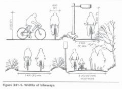
BICYCLE CIRCULATION, TSSsect. 341 What are the 4 common types of bikeways? |
1) Bike Path: separated from motor vehicles, ideal with dedicated right-of-way and separate furnishings (8-12' min)
2) Bike Lane: Part of roadway separated by textured strip or markings and designated with signage (5-6' min.)
3) Wide outside lane: less desirable, butcommon (14' min)
4) Shared roadway: Designated by signage or markings, also shared with pedestrians and cars, etc. Common, has highest potential with autos (5-6' min) |
|
|
BICYCLE CIRCULATION, TSS sect. 341 How does The America Association of State Highway and Transportation Officials (AASHTO) define "bikeway" |
any road, path, or way, which in some manner is specifically designated as being open to bicycle travel, regardless of whether such facilities are designated for the exclusive use of bicycles or are to be shared with other modes of transportation. |
|
|
BICYCLE CIRCULATION What are the 3 main types of conflicts at intersections for bicyclists? |
1) turning left 2) crossing intersection when vehicle is turning right 3) failure for someone to yield |
|
|
WATERSHED MANAGEMENT Terms to know angle of repose (AR) erosion (E) dry creep (DC) landslides (L) soil slippage (SS) |
AR - steepest angle on bare soil - 33 degrees E - wearing on land by water, wind, ice & gravity DC - movement of dry, bare soil by gravity L - occurs when soil becomes saturated by water - force of gravity SS - similar to landslides but on lesser scale. |
|
|
FIRE PREVENTION ON WATERSHEDS |
- maintain vigorous multi-aged stands of vegetation with high fuel moisture, low fuel loading and low dead-to-live ratio. |
|
|
FIRE PREVENTION ZONING & ZONES |
Zoning modifies the landscape that surrounds the blg. Distance from blg 30' Zone - irrigate preferably on level ground, not sloping - use native & non-native plants with high fuel moisture and low dead-to-live ratio 30'-100' Zone - known as 'greenbelt' - remove dead wood and prune trees with 5foot clearance from ground; use low shrubs and ground cover 100'-200' Zone - selective clearing & pruning - 'feathering out' - clear old plants to make room for new |
|
|
PEDESTRIAN CIRCULATION What are the 4 design criteria to consider when designing signage? |
1) Visual field 2) Scale of letters 3) Proportion of letters 4) Contrast between letters and background |
|
|
PEDESTRIAN CIRCULATION Seat Wall Dimensions |
16-18" wide and 14-18" tall |
|
|
PEDESTRIAN CIRCULATION Ramp and Handrail design criteria |
Ramp Width: One way use = 3' min. two way use = 5' min. Can vary depending on type and intensity of use. Slope: no greater than 1:12 or 8.33%.Exceptions at curb cuts where 1:8 or 12% is acceptable if the running length isless than 3' Landings: Provide a landing every 30' or less Turns: Can only occur at landings and shouldbe wide enough to accommodate a wheelchair. Refer to Americans withDisabilities Act Accessibility Guidelines (ADAAG) and to state and local codesfor dimensions. Handrails: important to include on allstairways and ramps. Height ranges from 30-34" (always check local codes).Extend end of rail 12-18" and round out. No less than 20' apart on widestairways. Lower handrail for children and wheelchairs |
|
|
FIRE Plant succession (as a potential fire hazard) |
Plant succession - changes in the composition of the plantecosystem over time - can be seen from the after effects of fire damage over time 1. fire destroys all vegetation 2. 1st succession - grasses and herbaceous plant material establish creates alow fuel moisture & high dead-to-live ratio environment in summer -potential fire hazard 3. after 2-3 years - 2nd succession - woody plant material develops with ahigher fuel moisture content and lower dead-to-live ratio - reducing fire risk.Thinning of plant material req'd as plants mature. |
|
|
FIRE What is dead-to-live ratio? |
Relative amounts of dead plant material tolive plant materialthe dead-to-live ratio increases as plants mature thereby increasing fire risk/hazard |
|
|
FIRE Fuel moisture (FM) Fuel loading (FL) Moisture Content (in wood) |
FM - the moisture content of living and dead plant materialgenerally - high in winter & spring low in summer & south facing slopes FL - is the amount of plant material/unit area increases as plants mature the amount of water contained in wood expressed as % relative to the weight of of dried wood |
|
|
LIGHTING High Mast Lights |
- hts btn 60'-100' - mercury vapor; metal halide & L.P. Sodium - used for large parking areas & highway interchanges - fixtures lowered for maintenance. |
|
|
LIGHTING Parking lot & Roadway lights |
- hts btn 20' - 25' - mercury vaor; metal halide & H.P. Sodium - used for streets, parking lot, commercial/industrial - low to medium suscetibility to vandalism |
|
|
LIGHTING Intermediate Height Lights |
- hts btn 10'-15' - incandescent; fluorescent + metal halide - used for pedestrian areas - med - high susceptibility to vandalism |
|
|
PEDESTRIAN CIRCULATION Know the average cone of vision and sense ofspatial enclosure dimensions as shown on figures 340-9 and 340-10 of TSS |
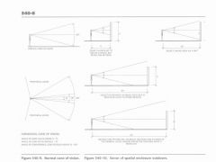
30 vert |
|
|
LIGHTING Low level landscape lights |
- less than 6' - incandescent; fluorescent: mercury vapor - highly susceptible to vandalism - possible glare problems |
|
|
LIGHTING Lamp types and characteristics |
Incandescent Warm white Best Low High Fluorescent Warm Cool white Good Med Med Mecury vapor Cool white Good Med Med Metal halide Cool white Best Med Med High Pres Sodium Yellowish Poor High Low Low Pres Sodium Yellow-orange V.Poor High V.Low |
|
|
PEDESTRIAN CIRCULATION What is average eye level for standingpedestrian? For seated pedestrian? |
Standing eye level - 5'2" Seated - 3'9" |
|
|
PEDESTRIAN CIRCULATION Stairway and Landing design criteria |
widths: min. width for public use - 60",for private use - 42" tread-riser ratio: should be held constant toavoid hazardous conditions Min riser = 4.5", max 6-7" Common formula 2R + T = 26-27" At least 2 steps, preferably 3 should bespecified (never just 1). Keep it less than 20 to minimize fatigue Landings - min. length is 5'. At most add 1landing every 12' in height - less recommended, for human comfort it isconsidered appropriate to add a landing every 5' or less. Greater than that maybe on purpose to control sight lines. |
|
|
PEDESTRIAN CIRCULATION Longitudinal Slope and Cross Slope criteriafor walkways |
Longitudinal Slope: for accessibility by all users 0-3% preferred 5% max 5-10% acceptable with certain climatic conditions 5-8% considered a ramp Cross Slope: for positive drainage 1% min (okay for porous materials 2% typical 3% max |
|
|
PEDESTRIAN CIRCULATION How are expected pedestrian traffic loadscalculated? |
By observing similar projects in other areas,formal studies, and professional judgment |
|
|
PEDESTRIAN CIRCULATION Formula for calculating walkway width andcommon Walkway widths to accommodate pedestrians and maintain psychologicalcomfort. |
24" for each pedestrian is necessary For two way traffic - 4' is minimum Consider: 30" from street curb and 18-30" next to building facade arecommonly unused, except in high density environments 2 people - 4'8" 3 people - 8'8" 4 people - 12'8" Formula: Pathway width = V(M)/S V - Given volume of pedestrians (e.g. 200/minute or 5/hour) M - Acceptable density (SF/pedestrian) usually ranges from 5ft^2 to35ft^2 S -Desirable rate of movement or walking speed (averages 260 ft/min) formula is used as a check because itdoes not consider street furniture, walkway edges, aesthetics and scale tosurrounding design etc. Walkways are ofter larger than minimum requirementfound with this formula. |
|
|
PEDESTRIAN CIRCULATION What are the recommended forward spatialbubbles for a public even, shopping, normal walk, pleasure walk? |
6', 9-12', 15-18', 35'+ |
|
|
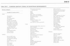
PEDESTRIAN CIRCULATION Types of Sensory Stimuli |
|
|
|
PEDESTRIAN CIRCULATION Why are transitional spaces and hierarchicalordering important design principles? |
Because movement through a spaces is avisual-spatial (kinesthetic) experience. |
|
|
PEDESTRIAN CIRCULATION A strong degree of what creates the mostcomfortable human environments? |
Spatial Enclosure |
|
|
PEDESTRIAN CIRCULATION What elements are crucial to the success ofmost spaces? |
Places to gather and places to sit to allow for interaction aswell as people watching. Food, and the activity of eating. |
|
|
LIGHTING What is color on lighting fixtures? |

1. apparent color described as warm to cool in appearance warm is favored when illumination is low cool is favored when illumination is high 2. color rendering index (CRI)a perception of an object's true color scale from 0 - 100. |
|
|
PEDESTRIAN CIRCULATION What is a primary determinant regarding theenjoyment of place? |
Social interaction, both passive and active isconsidered extremely important to enjoyment of place and can be influencedgreatly by the circulation system as this is a primary connection betweennatural and cultural amenities. |
|
|
PEDESTRIAN CIRCULATION What can affect ease of negotiation for apedestrian when moving from one destination to another? |
-Pedestrian density, including conflicts at intersections andgathering spots -Physical obstructions (trash receptacles, light fixtures, flagpoles, water hydrants, benches) -water or ice -excessive litter, including seeds & fruitdroppings -excessive wind |
|
|
LIGHTING What is a photometric chart? |
- used to illustrate a distribution of candlepower of lightingfixtures at a specific height or layout position |
|
|
PEDESTRIAN CIRCULATION What types of landmark features and visualcues can suggest purpose and expected behavior to the pedestrian? |
-walkway width (hierachary) -formality (curvi-linear = relaxedexperience) -paving material (expensive, or highly articulate materials suggestinggreater importance) -presence and quality of ancillary features -signage |
|
|
LIGHTING What is a lumen? What is a footcandle? |
Lumen (L) - amount of light emitted by a light source Footcandle (FC) - illumination incident at a specific point (think of foot on the ground - where light will be)1 FC = 1 L evenly distributed over 1 sq. foot. |
|
|
CONSTRUCTION DOCUMENTS What are construction documents? |
They consist of the drawings (graphic) andspecifications (verbal) and serve as instructions to the contractor. They arethe culmination of the design process. They begin the site development (constructionphase) of project administration. The contractor uses them for bidding andconstruction. They are organized by construction activity, however constructionis not linear, but a network of simultaneous activities. The documents help thecontractor translate construction into materials, equipment, and personnelneeds. |
|
|
CONSTRUCTION DOCUMENTS Who is the major source for constructionspecifications? |
Construction Specifications Institute (CSI) |
|
|
CONSTRUCTION DOCUMENTS What do specifications provide that drawingsdo not? |
Drawings establish dimensions & identifymaterials. Specs establish the procedural andperformance standards required to construct the design as shown on the plan byproviding detailed information on the materials required, fabricationprocedures, and the application of products and materials.It is important that they be well-written asthey provide the scope of work and the procedures for altering the scope(change-orders, deletions, etc). |
|
|
CONSTRUCTION DOCUMENTS Who is responsible for Record (as-built)drawings? |
The contractor keeps track of all changes tothe original construction documents and the LA creates the official record. |
|
|
CONSTRUCTION DOCUMENTS What are shop drawings used for? |
Sometimes it is more economical and efficientgive the contractor leeway on construction methods and materials of certainelements and the LA does not provide the construction details. In this case, toensure that the Contractor's intentions are in keeping with the overall design,the LA will ask for shop drawings. The contractor then provides to the LA forapproval before ordering materials |
|
|
CONSTRUCTION DOCUMENTS What drawing shows the construction accessroad and employee parking? |
The Site Preparation Plan Also shown on this plan: location ofstockpiles, trees to be removed and protected, limit of work, erosion control,concrete truck washout areas, staging area, storage areas, dewatering trenchesand/or construction siltation ponds |
|
|
CONSTRUCTION DOCUMENTS From what drawing can the contractor calculatehis quantities of materials? |
The Layout and Materials Plan |
|
|
CONSTRUCTION DOCUMENTS Why is it important to distinguish betweentrue north and magnetic north? |
Because they can vary up to 20 degreesdepending on the location |
|
|
CONSTRUCTION DOCUMENTS What are some of the additional drawings thatmight be included in the construction documents that are not usually includedwith the Primary Documents? |
Plan Enlargements Road profiles and sections Shop drawings Record (as built) drawings |
|
|
CONSTRUCTION DOCUMENTS List the 9 types of Primary Drawings found ina typical construction package. |
1) Cover or index sheet 2) Existing Conditions 3) Demolition Plan 4) Site Preparation Plan 5) Layout (dimensioning) and materials plan 6) Grading and drainage plan 7) Planting plan and details 8) Utility plan 9) Site details and sections |
|
|
CONSTRUCTION DOCUMENTS What are the 7 types of construction detailsthat should be included with construction documents? |
1) Earthwork sections 2) Pavement, curbs, and edgings 3) shelters and decks 4) Screens, walls, and steps 5) Furnishings and features 6) Utilities 7) Plant installation |
|
|
CONSTRUCTION DOCUMENTS Grading Plans include the followinginformation: |
Property lines, match lines, limits ofcontract and benchmark All site features including roads, parking,walls, steps, etc Existing contours and spot grades Proposed grading including: -high points, low points, ridge and swale center lines and grades -spot elevations at all changes of gradient, walk ends, and inlets -spot elevations at top and bottom of walls, steps, and ramps -floor elevation for every access level of each structure Subsurface drainage network Existing structures and trees to remain Tree protection Cut and fill calculations and profiles |
|
|
CONSTRUCTION DOCUMENTS What is included on a Layout and MaterialsPlan? |
all dimensions and appropriate cross references for: Existing Site features Property lines with bearings, easements, setbacks, match lines, limits ofcontract lines, and benchmarks Boring Locations Roads, parking, and service area Buildings and other structures with floor elevation, etc Outdoor lighting Other features including: walls, walks, steps, benches, and planters |
|
|
CONSTRUCTION DOCUMENTS What information is included on a Title Block? |
Sheet title Client's name Name, logo, and contact info for consulting firm Date Drawn by Checked by Revision block Job number Sheet number |
|
|
CONSTRUCTION DOCUMENTS All sheets in a drawing set should include thefollowing 7 items: |
1) Title block 2) Border with appropriate space for binding sheets 3) North arrow 4) Written and graphic scale 5) Registration seal 6) Legend, notes, and labels 7) References to copyright |
|
|
CONSTRUCTION DOCUMENTS A demolition plan shows all existing featuresthat are to remain or be removed. List the 6 types of features shown on aDemolition Plan. |
1) Structures 2) plant material 3) site furnishings 4) utilities 5) rock outcrops 6) clearing and grubbing |
|
|
CONSTRUCTION DOCUMENTS What 7 items should be included on theExisting Conditions Plan? |
All existing Site features include: 1) Contours and spot elevations (including ridges and swales) 2) Property lines with bearings, easements, setbacks, & benchmarks 3) Buildings or other structures 4) utilities - above and below ground 5) Total acreage 6) Existing vegetation 7) boring data |
|
|
CONSTRUCTION DOCUMENTS What 6 things does the contractor need toverify during the preliminary surveying phase of construction? |
1) major dimensions 2) roadway geometry 3) property boundaries 4) limits of construction 5) stockpiling areas 6) other horizontal measurements. |
|
|
CONSTRUCTION DOCUMENTS What are the 8 types of constructionactivities as described in TSS? |
1) Preliminary surveying 2) Tree protection, temporary conditions, erosion control, andtransplanting 3) Clearing, grubbing, and demolition 4) Topsoil stripping and stockpiling 5) Rough grading 6) Finish grading 7) Installation of site improvements 8) Planting and seeding |
|
|
EARTHWORK To achieve a balance between of cut and fillon the site. |
Hauling topsoil and subsoil is very expensive. Always try to keep a balance between cut and fill on site to save costs. Ifthere is an imbalance, then excavate a little more on a portion of the site.Excess cut can be used to make earth berms, ifthere is space available. |
|
|
EARTHWORK What are the Shrink/Swell factors? |
Soils, when excavated, swells from 12% - sand;20% - loam and 25% - clay.When compacted, 15% on average (sand = lessshrinkage; clay = more shrinkage) Rule of thumb Amount of cut measured should be reduced by 15% to account for shrinkage duringcompaction as fill. So, you need more cut than fill to balance earthwork on asite. |
|
|
EARTHWORK Define contour planes/method |
Mostly used by LA's Measure area of each contour (use 2 columns; 1 for fill and 1 for cut Multiply by the square of the map scale and by the contour interval |
|
|
EARTHWORK Define Average End Area |
Mainly used by engineers Primarily used for roads and pipelines by applying station points (1+00) every100 feet. Takes a series of cross sections at station pts Measure the area of cut and fill at each section Multiply by the distance between each sections |
|
|
EARTHWORK Define Grid Method |
Best used on relatively flat sites. Estimate by interpolation the existing and proposed elevation at each grid linesection. Convert to net cut or fill Add corners of each grid. Divide by 4. Multiply by the area of each grid square. |
|
|
EARTHWORK What are the 3 basic techniques for estimatingcut and fill? |
1. Average end area 2. Grid 3. Contour PlanesSee TSS pages 320 - 331 |
|
|
EARTHWORK What are the 5 earthmoving and constructionphases? |
1. Vegetation cutting, stripping and removal (clearing orgrubbing) 2.Topsoil stripping and stockpiling. Protect topsoil on site with perimeter silt fence 3. Rough grading. - mass moving of subsoil, proof-rolling, cut & fill proof-roll sub-grade means putting heavy equipment on existing subgrade to seeif it deflects 4. Trenching for footings and utilities 5. Placement of finish materials - incl. topsoil spreading, paving, planting |
|
|
PLANTING Note the characteristics of existingvegetation as design opportunities such as... |
-Identifying clearings that offer views andpotential building locations -Shade from nearby trees for summer outdooruse areas -Types of Vegetation that require preservation |
|
|
GEOLOGY The presence of bedrock poses limitationsfor... |
-Grading -Drainage -Siting Structures and Ball Fields |
|
|
SOILS Soil characteristics imply the suitability ofareas for the following issues... |
1. Siting Structures - soils with adequateload bearing capacity for building foundations, avoid poorly drained soils andwetlands 2. Recreational Ball-fields - want permeablesoils to provide drainage 3. Stormwater Management - want permeablesoils for stormwater ponds, conveyances, and infiltration facilities tofunction properly 4. Erosion - sandy or loose soils can be proneto erosion in steep slopes and may require mitigation design measures 5. Planting Limitations - some soil typeslimit the plant materials that can be used on a site |
|
|
Viewsheds |
HIGH POINTS & RIDGELINES...-offer desirable locations for viewing -for siting important buildings -for routing public walks and trails |
|
|
ELEVATIONS Identify a site's High and Low Points to reveal... General drainage pattern and extent of watersheds. HIGH AREAS... LOW-MID AREAS... |
HIGH AREAS...near top of watershed are NOT suitable for locating stormwater management features LOW-MID AREAS...will accommodate most of the watershed's stormwater management structures |
|
|
TOPOGRAPHY 2 Topographic Conditions that define a siteare its... |
Slopes and Elevations (take note of spotelevations on a site plan) |
|
|
SLOPES Steep Slopes > 15% Moderate Slopes 5-15% Gradual Slopes |
Steep Slopes > 15% Not conducive to cost effective construction and can cause significant impactsto the land. Moderate Slopes 5-15% Are not the best choices for recreational uses, BUT are suitable forsplit-level or terraced structures with sheared foundations. Gradual Slopes |
|
|
Carrying Capacity |
Amount of use a site can sustain withoutdamage to the resource. |