![]()
![]()
![]()
Use LEFT and RIGHT arrow keys to navigate between flashcards;
Use UP and DOWN arrow keys to flip the card;
H to show hint;
A reads text to speech;
180 Cards in this Set
- Front
- Back
|
Q: An applicant for an instrument rating must have at least how much and what type of flight time as a pilot? |
|
|
|
Q: When is an instrument rating required? |
|
|
|
Q: What are the recency experience requirements to be PIC of a flight under IFR? |
Within 6 calendar monthsthe PIC must performed and logged in actual/simulated conditions at least 6 instrument approaches, Holding procedures and tasks and intercepting and tracking courses through the use of navigational electronic systems. *61.57 & 91.109(c) allows use of an aircraft and/or a FTD |
|
|
Q: If a pilot allows his instrument currency to expire, what can be done to become current again? |
A pilot is current for 6 months following his/her instrument checkride or proficiency check. If a pilot does not do the requirements for currency, the pilot has 6 monts to compleate the requirements for currency under simulated conditions with a saifty pilot. If the secound 6 month time lapes the pilot must compleate a Introment Profenciay Check by an autorised instructor or flight examiner. |
|
|
Q: What are the required qualifications for a person to act as a "safety pilot"? |
|
|
|
Q: What conditions are necessary for a pilot to log instrument time? |
A pilot may log as instumrnt flight time only that time during which he/she operates the aircraft soly b refrence to instruments under actual or simulated conditions. |
|
|
Q: When logging instrument time, what should be included in each logbook entry? |
Each entry must include the location and type of each instrument appriach accomplished and the name of the safety pilot, if required. |
|
|
Q: What conditions must exist in order to log "actual" instrument flight time? |
Their is no FAA term for "actual instrument time", but a reasonable guild line would be flight solely biased on reference to flight instruments in weather under VFR minimums. |
|
|
Q: What is the definition of flight time? |
time that comences when a pilot moves ain aircraft under its own power for the purpose of flight and comes to a rest after landing. |
|
|
Q: How can a pilot use the PAVE chicklist to moniter and midigate risk? |
PIC - illness, meds, stress, alcohol, fatague Aircraft - airworthiness, proficiency in aircraft enVenvironment - weather, terrain, runway External Pressures - passengers, get there itis |
|
|
Q: What information must a PIC be familiar with before a flight? |
All availble information including: - Weather reports and forecasts - Fuel requirements - Alternate airports - Known ATC delays - Runway lengths of intended use - Take off and Landing distances |
|
|
Q: Fuel Requirements for an IFR/VFR flight? |
IFR - Enough for the first airport to include the approach, to the alternate and for 45 minutes of fuel remaining VFR - enough for the flight plus 30 minuts during the day and 45 at night |
|
|
Q: Before using a GPS for in IFR flight, what basic preflight checks should be made? |
- Verify the GPS is properl instlled and certified for the planned IFR operation. - Verify the database is current - Review any GPS and WASS NOTAMs - Review GPS RAIM availability for non-WASS gps - Review operational status of ground based NAVAIDs and related aircraft equipment. |
|
|
Q: Explain the function of RAIM? |
RAIM - Recever autonomuus integrity monitoring - is the self monitoring function performed by TSO-129 certified GPS to ensure adequite GPS signal at all times. The GPS will alert the pilot if the signals do not meet the criteria for safe navation use. |
|
|
Q: What are the required Day VFR instruments. |
FAR 91.205 Tachometer (for each engine) Oil Pressure Gauge Magnetic compass Airspeed Indicator Temperature Gauge for each liquid cooled engine Oil Temperature Gauge Emergency equipment Anti-collision Lights Fuel Gauge for each tank Landing gear position indicator Alitmeter Manifold Pressure Gauge for each engine Emergency Locator Transmitter Seat belts |
|
|
Q: What are the required Night VFR instruments. |
Fuses Landing light, if operated for hire Anti-collision light (beacon and/or strobes) Position Lights – Nav Lights (Red Green & white Source of electricity (battery & alternator) |
|
|
Q: What are the required IFR instruments. |
GRAB CARD Generator/alternator Rate of turn indicator Altimeter, sensitive (Kollsman window) Ball (inclinometer, the ‘level’ component of a turn coordinator ) Clock (digital display or sweep second hand) Attitude indicator Radios as required for navigation and communication Directional gyro DME or RNAV at FL240 and above if VOR is used |
|
|
Q: What are FREDA checks? |
Fuel Radios - current, next? VLOC or GPS? Engine - temp, pressure, leaned? Direction - check with compass Altimeter |
|
|
Q: what are the 4 T's |
TWIST - TURN - TIME - TALK |
|
|
Q: What is the GUMPS check? |
BC- boost and carb Gas - both Undercarriage - visually check and light indicator Mixture - rich Prop - full in Switches and seat belts to be completed before 'base leg' |
|
|
Q: What are the required tests and insections of aircraft and equipmenr to be legal for IFR flight. |
A - Annual inspection within the preceding 12 months (91.409) A - Airworthiness Directives (91.403) V - VOR check used for IFR every 30 days 91.171 1 - 100 hour inspection if used for hire or instruction 91.409 A - altimiter and static pressure systems checked every 24 months T - Transponder test every 24 months (91.413) E - ELT battery and condition tested every 12 months |
|
|
Q: Are electronic chart systems approved for use as replacements for aper reference material in the cockpit? |
A: Yes per AC 91-78 |
|
|
Q: How often are GPS databases required to be updated? |
Every 28 days for navigation databases, 56 days for terrain and airport data as needed. |
|
|
Q: When utilizing GPS for IFR navagation, are you required to have an alternate means of navagation approprite for the route of flight? |
Aircraft using GPS TSO-C129 or TSO-C196 (non-wass) under IFR must have alternate means of navagation appropriate to the flight. Aircraft wth a WASS recivier may use WASS as a primary means of navagation. No additional equipment is required. |
|
|
Q: How can a pilot determin what type of operations a GPS reciver is approved for? |
The pilot should refernce the FAA-approved AFM and AFM supplements to determin the limitions and operation procedures for the particular GPS equipment installed. |
|
|
Q: Can a handheld GPS be used for IFR operations? |
VFR and handeld GPS systems are not autorized for IFR navigation and may only be concirdered only as an aid to situational awareness |
|
|
Q: When must a pilot file an IFR flight plan? |
Prior to departure within or prior to entering controlled airspace, a pilot must submit a complete flight plan and recive clearance from ATC if weather conditions are below VFR minimums.The pilot should file at least 30 min prior to departure to minimize delay. |
|
|
Q: When will ATC delete from the system a departure flight plan that has not been activiated?
|
On average 1 hour from the preposed departure time. if a delay breaks this time inform ATC |
|
|
Q: When can you cancel your IFR flight plan?
|
Any time when operating outside of class A in VFR conditions.
|
|
|
Q: What is a composit flightplan?
|
A flight plan that has both a VFR and IFR part
|
|
|
Q: the requested altitude on an FAA flight plan represents which altitude for the route of flight - the initial, lowest or highest?
|
enter only the initial. any subsequent request should be sent to the controller
|
|
|
Q: What are the alternate airport requirements?
|
1-2-3 rule ; IF 1 hour before to 1 hour after your planeed ETA weather forcast must be at least 2,000' ceilings and 3 miles of visabality no alternate is required.
otherwise; precision : 600' celings and 2sm non-precision: 800' celings and 2sm no IAP: decent from MEA to landing must be VFR
pr |
|
|
Q: What is the definition of the term ceiling?
|
lowest layer of clouds or obstruction reported as broken, overcast, obscuration in AGL
|
|
|
Q: What minimums are to be used on arrival at the alternate?
|
if a IAP is listed, the minimums for that procedure is to be used.
|
|
|
Q: What are preferred routs and where can they be found?
|
Prefred routs are established between busier airports to increase system efficiency and capacity. Preferredd routs are listed in the Airport/Facility Directory (Chart supplement?)
|
|
|
Q: What are enroute low-altitude charts?
|
provide aeronotical information for navigation under IFR below 18,000 ft. All course are megnetic and all distances are notical miles. Revised every 56 Days
|
|
|
Q: What are 'aera charts' |
They show congested terminal areas at a larger scale. revised every 56 Days. |
|
|
Q: Where can information on possible navgational aid limitations be found? |
NOTAMs as well as A/FDs will contain current limitations to NAVAIDs |
|
|
Q: What other useful information can be found in the Airport/Flight Directory (Chart supplement?) which might be helpful in route planning? |
The A/FD contains additional information for each of the seven regions covered such as: >Enroute flight advisory services- locats and communication outlets >ARTCC - locations or sector frequencies >Aeronautical Chart Bulletins - recent changes after publication >Preferred IFR routs - high and low altitude >Special notices - flight service stations, GADO, Weather Service office phone numbers >VOR receiver checkpoints - locations and frequencies |
|
|
Q: What are NOTAMs? |
A: Time critical information which is either a tempory in nature or not known sufficiently in advance to publication in aeronotical charts or other operational publications. |
|
|
Q: What are the types of NOTAMs? |
A: D NOTAMs, FDC NOTAMs, POINTER NOTAMs, MILITARY NOTAMs, SAA NOTAMs |
|
|
Q: What are D NOTAMs |
A: Information that reuires wide dissemination regaurding enroute nav aids civil public-use airports listed in the A/FD, Facilities, services, and procedures |
|
|
Q: What are FDC NOTAMs? |
Flight information that is regulatory in nature including, but not limited to changes to IFR charts, procedures and airspace useage |
|
|
Q: What are SAA NOTAMs? |
Issued when Special Activity Airspace will be active outside the published scedule times and when required; SAA ncludes special use airspace (RA, MOAs, warning areas, and alert area airspace, Visual and instroment military traning areas aerial refueling) |
|
|
Q: How can a pilot obtain GPS NOTAMs? |
A pilot can specificaly request a FSS during a preflight briefing. |
|
|
Q: What instrumens operat from the pitot/static system? |
altimiter, VSI, and the airspeed indicator. |
|
|
Q: What type of errors is the altimeter subject to? |
>Mechanical errors - Differences beween ambien temperature and/or pressure can cause erroneous indications >inharent errors - non-standered tempature and pressure >Extreme cold errors- can show eranus alt between -50* -- 10* C >High to low look out below |
|
|
Q: For an IFR flight, what is the maximum allowable error for an altimeter |
75 feet |
|
|
Q: What is indicated altitude |
read directly from the altimeer when set to the correct altimiter setting |
|
|
Q: What is True altitude |
Vertical disance of the aircraft above sea level. Airport, terrain, and obstacle elevations on aerontical charts are true altitudes. |
|
|
Q: What is Absolute altitude |
the vertical distance of an aircraft above terrain in AGL |
|
|
Q: what is pressure altitude? |
altimiter set to 29.92 |
|
|
Q: what is densiy altitude? |
pressure altitude corrected for non standered temperture |
|
|
Q: what errors is the airspeed indicator subject to? |
>position error - caued by the static ports sensing erronous pressure (eg slipstreem) >density error - changes in altitude and tempature not compisated for by the instroment >compressibility error - packing of air into the pitot tube at high airspeeds ( normaly above 180kts) |
|
|
Q: How does the VSI work?
|
it measures the change of pressure from the static system to the aneroid. |
|
|
Q: What are the limitations of the VSI?
|
not accurate unless aircraft is stableised and is subject to a lag. |
|
|
Q: What instruments are affected whaen the pitot tube, ram air inlet, and drain hole freeze? |
Only the airspeed indicator will be affected. it will act like an altimeter, reads higher as an aircraft climbs and lower as an aircraft decends. it will read lower han actual in level flight. |
|
|
Q: What instruments are affected when the static port freezes? |
>Altimeter - indicates the altitude at which the system is blocked. >VSI - will show level flight |
|
|
Q: What corrective action is needed if the pitot tube freezes? If the static port freezes? |
Static - use alternate static or break VSI |
|
|
Q: What indications should you expet while using alternate air?
|
>Airspeed - greater than atual >VSI - show slight climb in level flight |
|
|
Q: What intruments contain gyroscopes? |
Attitude indicator, heading indiator and turn cordnator |
|
|
Q: What type of powe soures commonly used to power the gyroscopic instruments in an aircraft?
|
electrical, pneumatic, venture, wet vacuum pump, dry vacuum pump 4ca has an electric turn courdnater and a vacuum for attitude indicator and heading indicator. |
|
|
Q: What are the two important charcteristics of gyroscopes?
|
Preccession - allows force to be applied 90* from application point. Rate instruments like the turn cordnator use this principle |
|
|
Q: What information does the turn coordinator provide? |
slip - ball on inside -not enough rate of turn for the bank skid - ball on outside - too much rate of turn for the bank |
|
|
Q: What are the limitationjs of an attitude indicator?
|
normal between 100-110 for bank and 60- 70 for pitch. if they exceed this the indicator might 'tumble' or show inaccurately. |
|
|
Q: Is the attitude indicator subject to errors?
|
free from most errors but after rapid acceleration/deceleration might be a small pitch up/down attitude indicated. on a 180* turn during the roll out the indicator might show a slight climb and turn in the other direction. |
|
|
Q: what are some verriopus compass errors? |
>deviation - due to electrical and magnetic disturbances in the airraft >Dip errors: a. acceleration error - on east or west headings during acceleration compass turns north, deceleration ompas turns souh (ANDS) b. Northerly turning error -When turning in a northernly heading the compass leads the true heading. you should roll out before your desired heading. c. Southerly turing error - when turning to a southernly heading the compass lags. you should roll out after your desired heading. UNOS - undershoot noth over shoot south |
|
|
Q: At what rate does atomospheric pressure decrease with an increase in altitude?
|
aprox 1" Hg per 1,000' |
|
|
Q: What are standered temperature and pressure values?
|
15*C and 29.92 (in Europe ______) |
|
|
Q: State the general characteristic in regard to the flow of air around high and low pressure systems in the northern hemisphere |
High Pressure - Air flows outward, downward and clockwise |
|
|
Q: What causes the winds aloft to flow parallel to the isobars? |
the Coriolis affect
|
|
|
Q: Why does surfice winds generaly flow across isobars at an angle?
|
Surfice frictions cause wind to cross at an angle |
|
|
When tempature and dew point are close togetger what type of weather is likely? |
with a Dewpoint and tempeture spread of 5* visable moisture in likely in the form of clouds dew or fog
|
|
|
Q: What factor determins the type and vertical extend of clouds? |
the stability of the atmosphere |
|
|
Q: What is the difference between a sstable and unstable atmosphere? |
A stable atmosphere resists any upward or downward displacement. an unstable atmosphere allows an upward or downward disturbance to grow into a vertical or convective current |
|
|
Q: How do you determin the stability of the atmosphere? |
When temperature decreases uniformaly and rapidly as you climb (approaching 3* per 1,000) that is an indication of unstable air. If the air remains unchainged or decreases only slightly with altitude the air tends to be stable. when the air near the surface is warm and moist, suspect instability. |
|
|
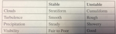
Q: List effects of stable and unstable on clouds turbulence, precipitation and visablility
|
|
|
|
Q: What are the main types of icing an airraft may encounter?
|
Structural, induction system, and instrument |
|
|
Q: Name the three types of structural ice that may occure in flight?
|
>Rime ice - small droplets like in a light drizzle, where the droplet freezes before it has time to spread out; -15* to -20* >Mixed ice - forms when drops very in size or are intermingled with snow or ice, the ice particles imbending itself in clear ice building a very rough accumulation; -10* to -15* |
|
|
Q: What is necessary for structural iceing to occure?
|
must be flying through visable moisture and at the point of impact must be 0*C or colder |
|
|
Q: What are the intensity categories of aircraft structural icing? |
a - trace - ice becomes perceptible; rate off accumulation slightly greater than sublimation (?) b - light - rate of accumulation may creat a problem if flight is prolonged in the enviroment c - moderate - rate if accumulation is such hat even a short encounters become potentially hazardous. d - severe - rate of accumulation is such that deicing/anti ice equipment fails to reduce or control the build up of ice |
|
|
Q: During preflight planning, what tyoe of meteorological information should you be aware of with respect to icing?
|
cloud layers - cloud bases and tops Freezing levels - will there be visible moisture there? Precipitation - location type of precipitation |
|
|
Q: What is the definition of the term "freezing level" and how can you determine where it is?
|
the lowest level where air temperature reaches 0*C. due to inversion layors you can have multiple freezing levels. you can find the information on aera forcasts, PIREPS, AIRMETs,SIGMETs, convective SIGMETs, low level signicant weather charts, surface analysis and winds & temps aloft. |
|
|
Q: What are the factors necessary for a thunderstorm to form and what are the three stages of a thunderstorm? |
For a TS to form you need moisture, unstable laps rate and lifiting action. 3 stages; 1. cumulus - updraft/lifting 2. Mature - precipitation falling signals downdrafts have developed and has entered the mature stage 3. Dissipation - downdrafts characterize the dissipation stage and the storm dies rapidly |
|
|
Q: What are "squall line" thunderstorms?
|
non-frontal narrow band of thunderstorms. oftern ahead of a cold front in moist unstable air. |
|
|
Q: state two basic ways that fog may form
|
cooling air to the dew point or adding moisture to the air. |
|
|
Q: What are some types of fog |
radiation fog, advection fog, upslope fog, precipition indued fog, ice fog |
|
|
Q: What causes radiation fog to form? |
Clear sky, little to no wind, small temp/dew point spread. forms almost exclusively at night/near daybreak |
|
|
Q: What is advection fog?
|
|
|
|
Q: What is upslope fog? |
formed by stable air being cooled as its being forced up terrain (eg mountain). can be quite dence ajd reach high altatudes. |
|
|
Q: What is ice fog? |
Occurs in cold weather far below zero and water vapor sublimates directly into ice crystals. same conditions for radiation fog except -25*F or colder |
|
|
Q: What is precipitation induced fog?
|
When warm rain falls through cool air, evaporation from the recipitation saturates the cool air and forms fog. can be dence last a long time and span over a large area. Mostly associated with warm fronts but can happen with slow moving cold fronts.
|
|
|
Q: Other than fog what are severl other examples of IFR weather. |
Low clouds, haze, smaoke, blowing obstructions to vision and precipitation. Fog and low clouds restrict visual navigation more than anything.
|
|
|
Q: What is the primary means of obtaining a weather briefing?
|
from an briefer at tge AFSS/FSS |
|
|
Q: What are sine examples of other sources of weather information?
|
Telephone briefing, private industry sources, computer through DUATS and FSS on common freq 122.2
|
|
|
What pertinent information should a weather brieding include?
|
Adverse conditions, VFR not recommended, Sybopsis, Current conditions, enroute forcast, Destination Forcast, Winds aloft, NOTAMs and ATC delay. Upon request pilots may obtain information on special use airspace(MOAs MTRs etc) aprox density altitude a. and GPS RAIM availability for 1 hr before and afer ETA
|
|
|
Q: What is HIWAS?
|
Hazardous inflight weather advisory service is an automatded continuous broadcast of inflight weather warnings, SIGMETs, Convective SIGMETs, Center Weather advisories, AIRMETs and urgent PIREPs
|
|
|
Q: What is a METAR
|
METARs are routine weather reports of an obsers interpretation of the weather conditions at a given site and time gerneraly every hour or as needed during fast changing weather. a special weather report |
|
|
Q: What are several types of weather observing programs?
|
Manual observatiobs (made by FAA or NWS personal) AWOS (include prefix 'AUTO' in the data), AWOS browdcasts (minout by minout observations) and ASOS/AWSS (Automated Surface Observiting System/Automated WEaather Sensor System)
|
|
|
What are PIREPs (UA) and where are the usually found?
|
AU is a abbreviation for 'Pilot weather reports'. report pf meteorological phenomena encountered by an aircraft in flight. (message type, location, time,altitude, aircraft type, at least one other element to describe the reported phenomena)
|
|
|
What are radar weather reports?
|
Contain information about precipitation observed by weather radar, information is up to 80min old and should only be be used at supporting information.
|
|
|
What are terminal Aerodome forecasts. TAFs |
Expected meteorological conditions within the statute mile radius of the center the airport runway during a 24 hour time. TAFs are the same whether codes as METARs. |
|
|
What is an area forecast |
Visual meteorological conditions, clouds, and general weather conditions over the area of the size of several states must be used along with in-flight weather advisories to to determine forecast in route weather conditions are airports were no tabs are issued. Issue three times a day by the AWC for each of the six areas in the contiguous 48 states |
|
|
What information is provided by an aviation area forecast |
Area forecast abbreviated FA include synopsis during the 18 hour valid period, Coluds and weather for the first 12 hour period for each state or group of states including , Cloud faces and tops, precipitation, his abilities between 3 to 5 statute miles and obstructions to visibility, and sustained surface winds 20 knots or greater. 12 to 18 hours categorical outlook for IFR, marginal VFR, or VFR, including expected precipitation and obstruction to visibility |
|
|
What are in-flight aviation weather advisories WST, WS, WA? |
Forecast surveys in right aircraft potential he hazardous weather. Convective SIGMET (WST), SIGMET (WT), and AIRMET (WA). |
|
|
What is a convective SIGMET? |
Imply severe or greater turbulence, severe icing and low level one cheer. Maybe issued for any convective situation which the forecaster fuse is hazardous to all categories of aircraft. Issued hourly at H +55. Special buttons are issued anytime as required an updated at H+55. And Alton kisses are either in observation and forecast or just the forecast which is valid for two hours.
Ex: severe thunderstorms |
|
|
What is a SIGMET? |
Advises of nine convective whether that is potentially hazardous to all aircraft. The maximum forecast is for a four hour period. issued when the following weather is expected to occur; severe icing not associated with the thunderstorms, severe or extreme turbulence or clear air turbulence, dust storms or sandstorms lowering the surface visibility to 3 miles or volcanic ash. |
|
|
What is an AIRMET? |
Are advisors F significant weather phenomena what describes the conditions are intensities does require for the issuance of SIGMETs. Intended for dissemination to all pallets in the preflight and in route phase of flight to inhanse safety. Issued on a scheduled basis of every six hours beginning at 0245 UTC. I'm scheduled updates and corrections are issued as necessary. They contain details about IFR, extensive mountain obscuration, turbulence, strong surface winds, icing, and freezing levels. |
|
|
What are the different types of AIRMETs? |
Sierra: describes IFR conditions and or extensive obscuration Tango corn described as moderate turbulence, have sustained surface winds of 30 knots or greater, and or non-convective low level wind shear. : Describes moderate icing and provides freezing level Heights |
|
|
What valuable information can be determined from a winds and temperatures aloft forecast? |
Favorable altitude for direction of flightflight. Areas of possible icing. Temperature inversion's and turbulence |
|
|
What valuable information can be determined from a winds and temperatures aloft forecast? |
Favorable altitude for direction of flightflight. Areas of possible icing. Temperature inversion's and turbulence |
|
|
What is a center weather advisory CWA? |
center weather advisory is an aviation warning for use by for use by aircrew to advoid adverse weather conditions in the end route internal environments. This is .not a flight planning product reflects on current conditions expected at the time of issuance and within two hours. |
|
|
Q: What are some weather charts you can use during the flight planning process? |
Surface analysis chart, Weather Depiction chart, Radar Summary Chart, Significant Weather Prognostic Chart, Short-Range Surface Progonstic Chart, Convective Outlook Chart, Constant Pressure Analysis Chart, and Freezing levels graphics. |
|
|
Q: What is a surface analysis chart? |
shows location of pressure systems and fronts. gives an overview of winds, temps and dew point at the chart time. |
|
|
What information doees a weather depicition chart provide? |
brawd overview of weather at the valid times baised on observations and METARs. Starts at 01z and republished every 3 hours. good place to start |
|
|
Q: Define LIFR, IFR, MVFR and VFR. |
LIFR - low IFR - Ceiling less than 500' and/or visablility less than 1 mile IFR - Ceiling 500 to 1,000 and/or visablility 1 to 3 miles MVFR - ceiling 1,000 to 3,000 ft and/or visibility 3 to 5 miles. VFR - Ceiling > 3,000 ft and visablity > 5 miles. |
|
|
Q: What are radar summary charts? |
Shows areas of partisipation and information including intensity, configuration, coverage, echo top and cell movement. DOES not show clouds, shows preciption. |
|
|
Q: What are short range surface prognostic charts? |
forcasts surface pressure systems, fronts abd precipitation for a 2 day period. shows a "snapshot" for each forcasted time 12,24,36 and 48 hour times. |
|
|
Q: describe a US low level significant weather prog chart. |
Shows weather forcasrts of avation weather hazards inteded as guideence materials for planning. icing is not specificaly forcasted. |
|
|
Q: Describe a mid-level significant weather chart |
same information of the lol level chart but for altatudes between 10,00 to FL 450 |
|
|
Q: What information may be obtained frim high level sifnificant weather prog charts/ |
for FL 250 to FL 650. Shows thunderstorms and cumulonimbus clouds, moderate or severe icing and turbulance, jet streams, tropopause heights, tropical cyclones, severe squall lines, volcanic eruption sites and wide sandstorms and dust storms |
|
|
Q: WHat is a convective outlook chart?
|
Tow panel chat that forcats general thunderstorm activity for the valid period. issued 5 times daily starting at 06z
|
|
|
Q: What are constant pressure charts? |
Information of aproxamate weather at certin pressure levels including ir tempature, wind, temp/dew point spread. shows high lows and troughs/ridges. issued twice daily |
|
|
Q: What significance do height contour lines have on a constant pressure chart?
|
Heights of the specified pressure for each station are analyzed through the use of the solid countour lines. they dispict highs lows troughs and ridges aloft in the same mannor as isobars on the surface chart. Closely spaced countours man strong winds like closely spaced iso bars.
|
|
|
Q: What significance do isotherms have on constant pressure charts? |
Show horizontal temperature varation at chart altitude. shows if your flight will be going to colder or warmer weather. subfreezing tempatures or dewpoint/dempature spread of 5 dagrees suspect icing conditions.
|
|
|
Q: What information does a freezing level graph chart provide?
|
shows lowest freezing level hights and their values relative to flight paths shown in msl. issued in 3 hour forcasts updated hourly.
|
|
|
Q: What information can a pilot obstain from current and forcast icing products?
|
Current icing product - hourly 3D diagnosis of the icing enviromnet. used for situational awareness only. issued hourly Foracst icing product - 3D prediction of icing. used tfor better awareness to sigmets and airmets but not to rplace them |
|
|
Q: 91.3 Responsivility and authority of PIC
|
directly responsibe for and is the final authority ti the operation of that aircraft.
|
|
|
Q: What are the right-of-way rules pertaining to IFR flights.
|
When weather conditions permit regardless of IFR/VFR statous all aircraft will see and avoid
|
|
|
Q: Are you required to report equioment malfunction under IFR in controlled airspave?
|
Any loss of VOR, ADF or low frequency navigation reciver capability. GPS anomalies using installed IFR certified GPS/GNSS recivers. Compleate or partial loss od ILS recever. Imparement of air/ground communication capability. and Loss of any other equipment installed in the aircraft that may impaur safety and/or the ability to operate under IFR.
|
|
|
Q: How can your IFR clearance be obtained?
|
-Through ATC at a towered airport (ground/clearence) -over the telephone or radio through a RCO (radio communication outlet or ground communication outlet -once airborn in VMC via radio through ARTCC |
|
|
Q: What does "cleared as filed" mean? |
Will issue an abbreviated clearance if the route can be approved as filed on the flight plan.
|
|
|
Q: What items are given in an IFR cleararance?
|
C - clearance limit to destination or fix R - route (initial heading) A - altitude (initial altatude) F - frequency (departure) T - transponder |
|
|
Q: What does clearance void time mean?
|
When op[eratuion at an uncontrolled field may recive a clearance containing a provision the clearance is void if not off by a certin time. |
|
|
Q: What is the purpose of the turn hold for release when included in an IFR clearabce?
|
used to delay an aircraft departure for traffic management resibs, a pilot may not depart utilizing that IFR clearance until a release time or additional intructuibs are recived from ATC.
|
|
|
Q: What leagal weather minums are nessicary to take off?
|
For Part 91 none. For Part 121,125,129 or 135 flights if no miniums are listed for an airport an aircraft with 2 engins or less 1sm vis is required. With more than 2 engins 1/2sm visablilty is required.
|
|
|
What is concitered "good operation practice" in dertermining takeoff minums for IFR flight?
|
If an instrument approach procedure has been prescribed for that airport use the minimums for that approach fortajeoff. iff no approach procedure is available use basic VFR minima
|
|
|
Q: What are DPs and why are they necessary?
|
Preplaned IFR procedures that provide obstruction clearance in the termanl area to the approate enroute airway. Also increases efficiency and reduce congestion. pt 91 pilots are encouraged to file and fly DP at night, during marginal VMC and IMC when avaible
|
|
|
Q: What are the two types of DPs? |
ODPs (obsibstacle Departure Procedures) and SIDs
|
|
|
Q: What are the two types of SIDs?
|
Pilot navigation SIDs and Vector SIDs
|
|
|
Q: What criteria are used to provide obstruction clearance during departure?
|
calculations are baised on the pilot crossing the departure end of the RW at 35 ft and climbing to 400ft until the first turn at a gradient of 200feet per NM.
|
|
|
Q: Where are DPs located?
|
Will be listed by airport in the IFR minimums and departure procedures section, section L of the terminal Procedures Publications.
|
|
|
Q: Must you accept a SID id assigned one?
|
IF you cannot comply with a SID or possess at least the textual verson of the SID you cannot accept. If you simply wish not to fly a SID put NO SID in the remarks section.
|
|
|
How does a pilot determine if takeoff minmums are not standard or departure procedures are published for an airport?
|
in the charts note section a T will be placed in a black triangle. |
|
|
Q: Prior to departing an airport on an IFR flight, a pilot should determine whether they will be able ti ensure adequate separation from terrain abd obstacles. What information should this include? |
Type of terrain or abstacles in the vicinity of the departure airport. Wether an ODP is avable. If avoidance can be maintained viusaly or ODP should be flown. Affect of degraded climb performance and actions to take in event of engine loss during departure.
|
|
|
Q: If an ODP is published for the RW you are departing are you required to fly it? |
No
|
|
|
Q: What is the recommended climb rate procedure when issued a climb to an assigned altitude b ATC? |
Decend or Climb rate consistent with the optimum rate consistent with the operating charistics of the aircraft to 1,000 feet above/below then 500-1500 fpm until assigned altitude is reached.
|
|
|
What are different methods are used to check VOR equipment?
|
1.VOR test signal +/- 4 2. Radio repair station test +/- 4 3. VOR airborn checkpoint +/- 6 4. Airborn over prominent landmark on establishe Airway more than 20 NM +/- 6 5Dual VOR check when both tuned from same vor is +/- 4 |
|
|
Q: What records must be kept concerning VOR checks? |
Each person making a VOR check shall enter the date, place and bearing error and sign the aircraft log or other reliable record.
|
|
|
Q: Where can a pilot find the location of airborn checkpoints, ground checkpoints and VOT testing stations?
|
Can be found in the A/FD
|
|
|
What procedure is used when checking VOR receiever accuracy with a VOT?
|
Tune ti VOT freq of 108MHz. with CDI centered the OBS should read 0 with to/from indication from or the OBS should read 180 showing TO Remember C182: 18 tooo... |
|
|
Q: Where is altutyde encoding transponder equipment required? (Mode C)
|
-at or above 10,000MSL excluding SFC-2500AGL -W/in 30nm class B -W/in Class C -Aircraft flying into/within/or across tge ADIZ |
|
|
Q: What are the 4 transponder codes?
|
1200.........VFR 7700.........emergency 7600.........lost coms 7500.........hijack |
|
|
Q: Would an incorrect altimeter setting have an effect on MODE C altitude information?
|
No, altaude reporting information are preset at 29.92
|
|
|
What do the folling acronyms stand for? ALS...VASI....PAPI...REIL |
ALS....approach lighting system VASI.....visual approach slope indicator PAPI....precision approach path indicator REIL....runway end identifyier lights |
|
|
Q: What is the purpose of runway aiming point markings?
|
The aiming point serve as a visual aimoing point for pilots 1,000 ft from the threshld.
|
|
|
Q: When issued taxi instructions to an assigned takeoff runway are you automaticly autorized to cross any runway that intersects your taxi rout? |
no; ypu must recive a runway crossing clearnce for ech runway crossing |
|
|
Q: define MEA |
lowest publishedltatude between nav aids that ensures acceptable signal coverage and obstical clearnce. |
|
|
Q: define MOCA |
minium offroute clearnce altatude ensures obstical clearance and ensures accaptable nav aid signal within 22nm. |
|
|
Q: define MCA |
altatude where you must be when crossing a crossover point between two nav aids. |
|
|
Q: IFR crusing altatudes |
0-179 - Odd 180-359 - even |
|
|
Q: on direct flights not on radials/airways what serves as cumpuslary reporting points? |
pilots must report each point used to define the route |
|
|
Q: What pre-flight planning for taxi operations should be integral part of the pilots fligh planning process. What information should be included with this, |
- review and understand airport signage - review the airport diagram, planned taxi route and any hotspots - review latest airfield notams and atis plan for critical times and location on the taxi route ( complex intersections, runway crossings etc) - compleat as many aircraft checklists pryor to taxt. |
|
|
what is an airport surface hotspot?
|
part of the taxiway that has a increased risk of runway incursions or surface incadedts eith caused by confusing layouts or a history.
|
|
|
when issued taxi instructions to an assigned takeoff runway are you automaticly authorized to cross any runway that intersects your taxi route?
|
NO, you must recive runway crossing clearance for each runway that a taxi route crosses.
|
|
|
What are IFR crusining altitudes? |
0 - 179 ........ odd thousand 180 - 359 .....even thousand |
|
|
What procedure are applicable concerning courses to be flown when operation IFR?
|
unless otherwise authorize authorized by atc, no one may operate an aircraft within controlled airspace under IFR except on a air traffic serives route along the centerline of that route or any other route along the direct course between the navigational aids or fixes defining that route.
|
|
|
on a direct flight not flown on radials or courses of established airways or routs what points serve as compulsory reporting points?
|
For flights along a direct route, regardless of the altitude or flight level being flown including flights under "VFR on top clearance", pilots must report over each reporting point used in the to determin the route of the flight.
|
|
|
What are "unpublished" RNAV routes? |
Unpublished RNAV routes are direct routes based on area navagation capability, between waypoint defined in termns of latitude/longitude coordinates, degree-distance fixes, or offsets from established routes/airways at a specified distance and direction. radar montoring by atc is required on all unpublished RNAV routes |
|
|
What report should be made to ATC at all times without specific request? |
1-When vacating previously assigned altitude for a new one 2-When an altitude change will be made while on a VFR on top clearance 3-When unable to climb/descend 500fpm 4-When approach has been missed. 5-Change in average true airspeed varies by 5% or 10 knots then filed on the flight plan. 6-Time and altitude upon reaching a holding fix or point that the pilot is cleared to. 7-when leaving assigned holding fix. 8-Any loss in controlled airspace or radios or navigation equipment. 9-Any information relating to the safety of the flight 10-upon entering weather conditions which have not been forecast, or hazardous conditions which have been forecast. |
|
|
What reporting requirements are required by ATC when not in radar contact. |
-When leaving final approach fix inbound on the final (nonprecision) approach, or when leaving the outer marker (or fix used in lieu of the outer,arker) inbound on final (precision) approach. -a corrected estimate at anytime it becomes apparent that the previously submitted is in error of 3 minutes. |
|
|
What items of information should be included in every position report? |
a-identification b-position c-time d-altitude e-type of flight plan (not required IFR) f- ETA and name of next reporting point g- name of next reporting point h-remarks |
|
|
When used in conjunction with ATC altitude assignments, what does the term "pilots discresetion mean? |
the pilot is offered the option strting the climb or decend whenever they want. The pilot may temporary level off at any intermediate altatude, howere after vacating an altatude the pilot may not return to that altitude. |
|
|
Explain the terms "maintain" and "cruise" as they pertain to an IFR altitude assignment. |
maintain - maintain assighned altatude cruise - used to assign a block altitude from the minimum IFR altatude to the assighned altatude. the pilot may fly at any altatude with climbs/decents at the pilots discression. However once a pilot starts a decent and verbally reports leaving the altatude he may not return to that altatude w/out additional ATC clearence. |
|
|
Can a cruise clearance authorise you to execute an approach at the destination airport? |
Yes, ATC may issue a cruise clearance that autorizes you to execute an approach upon arrival at the destination airport. When peration in unctrolled airspace on a cruise clearance, you are responceable for determining the minimum IFR altatude. In addition desent and landing at an airport in unctrolled airspace are govered by VFR rules |
|
|
Why would a pilot request VFR-On Top clearance? |
A piot on an IFR flight plan operation in VFR weather may request VFR-On-Top in lieu of an assigned altitude. for reasons such as turbulence, more favorrable winds aloft etc. the pilot has flexability to pick his altatude (subject to ATC restrictions). PILOTS DESIRING TO CLIMB THOUGH A CLOUD HAZE SMAKE THEN CANCEL THEIR ifr FLIGHT LAN OR OPERATE vfr ON TOP may request VFR-on-top |