Reading...
![]()
Play button
![]()
Play button
![]()
Use LEFT and RIGHT arrow keys to navigate between flashcards;
Use UP and DOWN arrow keys to flip the card;
H to show hint;
A reads text to speech;
138 Cards in this Set
- Front
- Back
|
Perihelion
|
earth closest to the sun Jan
|
|
|
Aphelion
|
earth furthest away from the sun July
|
|
|
Lithosphere
|
stone
|
|
|
atmosphere
|
air
|
|
|
hydrosphere
|
water
|
|
|
Earth
|
3rd rock from the sun, 5th largest in diameter
|
|
|
shape of earth
|
oblate spheroid (imperfect sphere)
|
|
|
Great circle
|
equator/north pole
|
|
|
Small circle
|
north pole/ north pole
|
|
|
Latitude
|
0-90 degrees measures north and south
|
|
|
Seven latitudes (broken up into 3rds)
|
Arctic circle, tropic of cancer, equator, tropic of Capricorn, Atlantic circle
|
|
|
degrees for arctic circle
|
66.5N
|
|
|
degrees for tropic of cancer
|
23.5 N
|
|
|
degrees for equator
|
within the few degrees of the equator
|
|
|
degrees for tropic of Capricorn
|
23.5 S (23 and 30 minutes)
|
|
|
degrees for Atlantic circle
|
66.5 N
|
|
|
Longitude
|
0-180 degrees, east-west
|
|
|
Geographic grid
|
graticule
parallels and meridians |
|
|
Earth rotation
|
west to east day and night
|
|
|
Earth revolution
|
365 days
|
|
|
Day 1 Winter solstice
|
Dec 23.5S = Tropic of Capricorn = cut through the equator (12hr days/nights)
|
|
|
solar altitude
|
90 - arc length
|
|
|
arc length
|
your location - declination
|
|
|
Tropic of Capricorn solar altitude
|
arc length ( 23.5-23.5= 0 )
90-0= 90 answer varies between negatives and positives depending on direction |
|
|
Day 2- equator (0)
|
Mar 21. Spring Equinox in NH
|
|
|
Day 3- 23.5degrees N. T. of Cancer
|
June 21 Summer solstice in NH
|
|
|
Day 4- equator (0)
|
sept 21 fall Equinox in NH
|
|
|
How many time zones are in the world>?
|
24 standard time zones
|
|
|
What is temperature?
|
Heat energy (the movement of different molecules)
|
|
|
What 3 scales measure temperature?
|
Fahrenheit, Celsius, kelvin
|
|
|
Electromagnetic Radiation
|
Oscillation of electrons
|
|
|
Solar Wavelengths
|
Distance betweens two successive wave crests
Electromagnetic spectrum of wavelengths 1. Visible light (short wave length) 2. Ultraviolet radiation 3. Near infrared radiation (long wave length) |
|
|
Insolation
|
Incoming solar radiation
Shortwave energy |
|
|
Terrestrial Energy
|
Longwave energy
|
|
|
Reflection versus Absorption
|
An object that is a good absorber of insolation warms up rapidly (its atoms vibrate more rapidly and more easily than an object that is a good reflector.)
|
|
|
Scattering
|
Gas molecules and particulate matter deflect light waves and redirect them
|
|
|
Greenhouse Effect
|
The atmosphere easily transmits shortwave radiation from the sun.
|
|
|
Conduction
|
Heat energy (vibration of atoms) passes from one place to another by this method.
|
|
|
Convection
|
This is the movement of mass by the gain or loss of heat energy.
-Warming air gains heat, expands and rises -Cooling air loses heat, contracts and sinks |
|
|
Advection
|
This is the horizontal transfer of heat such as by wind or air masses.
|
|
|
Adiabatic Cooling and Warming
|
This is the change in pressure and therefore the temperature of air that is rising or descending
|
|
|
Latent Heat
|
-This is heat stored in the air with water vapor.
-It is non-sensible (“hidden”) energy, as it cannot be felt. -It becomes heat of condensation (sensible), when the water vapor condenses and becomes liquid water droplets. |
|
|
Atmospheric Obstruction
|
Clouds and haze deplete insolation
|
|
|
Western Intensification
|
Western sides of oceans, middle latitudes, warm currents
Flow faster and are wider and deeper than counterpart cold currents on opposite side of oceans |
|
|
Prominent Controls of Temperature
|
Altitude
Latitude Land-Water Contrasts Ocean Currents |
|
|
Composition of the Atmosphere
|
Nitrogen and oxygen dominate
|
|
|
Particulates (Aerosols)
|
Tiny solid and liquid particles
Effects on weather and climate |
|
|
Troposphere
|
lowest part of the atmosphere -Our weather occurs here
|
|
|
Tropopause
|
upper part of troposphere
|
|
|
The Stratosphere
|
Immediately above the tropopause
Warms with rising altitude due to UV absorption Upper limit – Stratopause, where warming stops |
|
|
The Mesosphere
|
Immediately above the stratopause
|
|
|
The Thermosphere
|
Warms dramatically with rising altitudeFew oxygen molecules to transfer heat
Radio waves bounce off this layer from surface |
|
|
Pressure
|
Decreases with increasing altitude
|
|
|
Homosphere
|
Zone of uniform distribution of gases
|
|
|
Heterosphere
|
Zone of layers
Gases are in layers according to molecular weights |
|
|
Weather versus Climate
|
short vs. long term
|
|
|
pressure creates?
|
wind
|
|
|
what is Atmospheric Pressure?
|
Gas Molecules in motion
|
|
|
Atmospheric Pressure
|
Decreases with increasing altitude
|
|
|
Air pressure may be influenced by the _of air.
|
movement
|
|
|
Dynamic High Pressure Air Masses
|
Strongly descending air produces a dynamic high.
A very cold Earth surface produces a thermal high. |
|
|
Dynamic Low Pressure Air Masses
|
Strongly rising air produces a dynamic low.
A very hot Earth surface produces a thermal low |
|
|
Instrument to Measurement of Pressure
|
Barometer
|
|
|
Wind refers to
|
horizontal movement of air
|
|
|
Movement of wind
|
from high pressure to low pressure = Pressure Gradient
|
|
|
Coriolis Effect
|
Pulls wind to right in northern hemisphere
Pulls wind to left in southern hemisphere |
|
|
High-pressure system
|
-also called anticyclone
-circulating body of air -descending air -clockwise circulation in northern hemisphere |
|
|
Low-pressure system
|
-also called cyclone
-circulating body of air -rising air -counterclockwise circ. in northern hemisphere |
|
|
Wind Speed
|
Determined by the pressure gradient
Closer spacing of isobars, steeper the pressure gradient, faster the wind blows |
|
|
The General Circulation of the Atmosphere
|
Idealized Pattern
Uniform surface No Earth rotation |
|
|
Seven Surface Components of Global Circulation
|
Polar high
Polar easterlies Polar front (subpolar low) Westerlies Subtropical high Trade winds Intertropical convergence zone |
|
|
Where water Occurs in three forms in the atmosphere
|
Ice
Liquid Water vapor |
|
|
Adhesion
|
stickey
|
|
|
Latent Heat
|
water vapor in the atmosphere
|
|
|
Evaporation
Rates (Controls) |
Temperature of air
Temperature of water Humidity Wind |
|
|
Evapotranspiration
|
when plants take up water and evaporate the water
|
|
|
The warmer the air, the _ water vapor can be in the air?
|
more
|
|
|
Dew Point Temperature
|
Temperature at saturation
|
|
|
Higher dew point, _ amount of moisture?
|
higher
|
|
|
Dew point
|
the temp to which the air must be cooled to form dew
|
|
|
NEGLIGENT INFLICTION OF EMOTIONAL DISTRESS
|
A defendant may be liable for NIED to a bystander to an accident or intentional tort that causes the bystander
1. suffer severe emotional distress 2. because they were close in time, place or relationship 3. to the other person . Some jurisdictions require an actual impact on the person of the plaintiff and others require a physical manifestation of the emotional distress. |
|
|
Adiabatic Processes
|
the processes by which air cools as it raises in the air.
|
|
|
lapse rate
|
what the air look like as it moves throughout the atmosphere
|
|
|
when air is raising before dew point
|
dry adiabatic lapse rate 10degreese
|
|
|
when air is raising (cooling) past dew point
|
Saturated Adiabatic Lapse Rate
|
|
|
when temp and humidity (dew point) are the same
|
lifting condensation level (LDL), the lowest point that clouds can occur
|
|
|
when air is descending (warming)
|
dry adiabatic lapse rate (always and only)
|
|
|
Cumulus
|
puffy fair weather clouds
|
|
|
Stratus
|
flat layered clouds (overcast)
|
|
|
Altocumulus
|
high puffy clouds
|
|
|
Cirrus
|
wispy ice crystal clouds
|
|
|
Air Masses Characteristics
|
Troposphere
Dimensions Uniform properties Distinct from the surrounding area |
|
|
Origin
Source Regions |
Continental (DRY AIR) or Maritime (Oceanic) (WET AIR)
|
|
|
Latitude
|
E = 0º - 10º Equatorial (warm)
T = 10º - 35º Tropical (warm) P = 55º - 70º Polar (cold) A = 70º -90º Arctic / Antarctic (cold) |
|
|
Types :
E mT cT mP cP A |
E – Equatorial
mT – maritime Tropical cT – continental Tropical mP – maritime Polar cP – continental Polar A – Arctic / Antarctic |
|
|
define front
|
when one air mass collides with another air mass
|
|
|
Midlatitude Disturbances
|
Battleground between tropical and polar air masses
|
|
|
Symbols for Fronts on Weather Maps
|
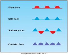
|
|
|
Midlatitude Cyclones
|
Large, migratory low pressure systems
Path of movement Other names Form in a zone of air mass convergence (35º to 70º latitude) |
|
|
If air moves fast does it rise or lower pressure?
|
lowers
|
|
|
Midlatitude Anticyclones
|
Upper air convergence
Subsidence High surface pressure Diverging surface winds |
|
|
Relations of Cyclones and Anticyclones
|
alternating: Often occur in next to each other in midlatitudes
Anticyclone forms a cold front on its leading edge |
|
|
Locations of Anticyclones and Cyclones
|
System of highs and lows, 35º to 70º of latitude
East-West migration Dominates midlatitudes, especially in winter |
|
|
Hurricanes
|
Intense Tropical Cyclones
Regional Names Tropical Disturbances Tropical depressions 0-38mph Tropical storm 39-73mph Tropical Cyclone (Hurricane) 74+ mph |
|
|
Hurricane Season
|
Warm seasons
Summer/Fall The Atlantic hurricane season runs from June 1 through November 30 |
|
|
Hurricane
|
Atlantic, East Pacific
|
|
|
Typhoon
|
West Pacific
|
|
|
Cyclone
|
India
|
|
|
Hurricane Characteristics
|
Intense low pressure
Cyclonic convergence Minimum wind speed Heavy rain Little to no Lightning Energy source and release |
|
|
Hurricane structure
|
Towering cumulus and cumulonimbus clouds
|
|
|
Hurricane growth
|
Heat energy in water (sensible heat)
Evaporates, rises (low pressure) Condenses, warms (latent heat) |
|
|
T or F? The lower pressure of a hurricane causes the sea level to rise
|
True
|
|
|
hurricane category scale
|
Safir-Simpson Scale
|
|
|
Thunderstorms and Tornadoes
|
Small storms of local significance
Associated with larger storms, too |
|
|
lighting
|
the evening out of the negative cloud to positive ground charge. Huge discharge of static electricity
|
|
|
Thunder
|
Rapid expansion and contraction of air
|
|
|
Photograph of IR light
|
Temperature
Good for Tops of Clouds |
|
|
Weather
|
state of the atmosphere at a specific place and time on Earth’s surface.
|
|
|
Climate
|
average values of weather elements, such as temp and precipitation, over an extended period of time
|
|
|
Variables that Influence Climate
|
-Latitude – intensity of radiation, length of day
-Seasonality – annual variation of sun angle -Air Circulation -Maritime/Continental – proximity to water can increase precip. and reduce temp range -Topography |
|
|
Major climate zones of the Old World, as recognized today
|
Equatorial warm wet
Tropical hot dry Subtropical warm temperate Midlatitude cool temperate High-latitude cold |
|
|
Köppen Classification System
|
Avg monthly temp
Avg monthly precip Total annual precip |
|
|
Group A
|
Tropical Humid Climates- no true winter
|
|
|
Group C
|
Mild Midlatitude Climates- cool wet Mediterranean (Csa, Csb)
Humid subtropical (Cfa) Marine west coast (Cfb, Cfc) |
|
|
Group D
|
Severe Midlatitude Climates- Northern Hemisphere with large annual temperature range
Continentality |
|
|
Group B
|
Dry Climates with very wide temp range
|
|
|
Group E
|
Polar climates- dry and cold xtreme seasonal contrasts in sunlight/darkness
|
|
|
Group H
|
Highland Climate- Dominant Controls
Altitude Slope aspect and slope angle |
|
|
Climate Change has 3 Major areas of interest
|
Chronology Reconstruction Theories
|
|
|
Chronology
|
what do we think has happened in the past
|
|
|
Factors That Can Change Energy Balance
|
Albedo
Moisture Solar Output Orbital Variations Green House Gasses |
|
|
Continental Drift
|
The Location of the Continents Can Affect Ice Development
|
|
|
3 Orbital Variations
|
Precession Obliquity Eccentricity
|
|
|
Thermohaline circulation
|
ocean currents
|
|
|
Positive Feedback
|
Warming Promotes Warming
|
|
|
Negative Feedback
|
Warming Promotes Cooling
|
|
|
Global climate change Supportive Evidence
|
Dramatic Temperature Change
Increase in Greenhouse Gasses Increase in Weather Disasters Melting Ice |
|
|
Possible Affects from global climate change
|
Increase in Sea Level
Decrease in Ice Change in Climate Zones Increase in Intense Precipitation Events Ice Age |