![]()
![]()
![]()
Use LEFT and RIGHT arrow keys to navigate between flashcards;
Use UP and DOWN arrow keys to flip the card;
H to show hint;
A reads text to speech;
10 Cards in this Set
- Front
- Back
|
Dynamic Range? |
The difference between the smallest and largest usable signal through a transmission or processing chain or storage medium. |
|
|
Signal-to-noise ratio? |
A measure used in science and engineering that compares the level of a desired signal to the level of background noise. It is defined as the ratio of signal power to the noise power, often expressed in decibels.
|
|
|
Full width at half maximum?
|
An expression of the extent of a function given by the difference between the two extreme values of the independent variable at which the dependent variable is equal to half of its maximum value.
|
|
|
Types of computer monitors? |
Cathode Ray Tube (CRT) Liquid crystal displays (LCDs): compact, lightweight Plasma displays: suitable for large, relatively compact displays, but expensive Light emitting diodes (LEDs): built on plasma technology; backlit diodes for more intense lighting and finer colour resolution |
|
|
Types of printers? |
Dotmatrix: B/W, slow, vector/raster, cheap, bad quality, A3 Pen plotters: Colour, slow, vector, medium quality, A0 Laser printers: Colour, fast, vector/raster, expensive, high quality, A4 Bubbeljet plotters: Colour, slow/medium, vector/raster, cheap, medium quality, A0 Imagesetters: Colour, slow/fast, vector/raster, very expensive, very high quality, A0 |
|
|
Satellite advantages over aerial remote sensing? |
*Synoptic view (large areas)
*Fine detail? *Systematic, repetitive coverage *Maintain worldwide cartographic infrastructure *Monitor broad-scale changes, e.g. environmental issues |
|
|
Apogee? |
Point farthest from earth |
|
|
Perigee?
|
Point closest to earth |
|
|
Inclination? |
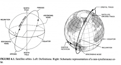
Angle formed by satellite track… between equator & descending node(angle between axis @ N pole & line perpendicular to plane of orbit; counterclockwise trajectory)
|
|
|
Orbit period? |
Time taken to complete an orbit. |