![]()
![]()
![]()
Use LEFT and RIGHT arrow keys to navigate between flashcards;
Use UP and DOWN arrow keys to flip the card;
H to show hint;
A reads text to speech;
43 Cards in this Set
- Front
- Back
|
2.1: At a basic level, explain how a computerworks regarding: long-term memory, RAM, CPU or GPU. Have the perspective of you interacting with a Word document, your thesis. |
- RAM (Random Access Memory): storage for random data to insure that the computer runs quickly and smoothly. Nothing is stored permanently in the RAM (loses memory w/o electricity). - Paging moves programs from hard disk (long-term) to RAM. Larger RAMS can run more programs at once. - CPU (central processing unit): brains of the pc. Carries out instructions of a computer program by performing basic arithmetic, logical, control and input/output - GPU (graphic processing unit): creates image on the screen.
|
|
|
2.2: Be able to fill in or answer questions regarding “practical memory sizes”, slide 5. |
|
|
|
2.3: Explain some benefits of a well maintained folder/file structure. |
- Backtrack your mistakes - No lost files means no lost data
|
|
|
3.1: When,where, and who founded ESRI? |
Founded in1969 in Redlands, CA by Jack and Laura Dangermond. |
|
|
3.2: T/F? There are only a couple software options to carry out GIS task. |
False |
|
|
3.3: List 3 other GIS software packages available to you. |
"GRASS" (open source), "Q GIS," and "R" (statistical package) |
|
|
3.4: What are the 4 groupings of GIS areas? |
- GIS packaging - Webmapping - GIS components - Statistical |
|
|
4.1: What issueswill your organized and diligent file management solve? |
- Back up in case of Arc Crash (saving regularly) - Locating files and data (or figuring out if you even ever got certain data) |
|
|
4.2: When sharingspatial projects, what file structure issues must you consider? |
All the files must go! Another person can't open your ArcMap file without the correlating data folders. |
|
|
4.3: What does Mr. Help mean? What is each component of Mr. Help? |
- Movement: How entities move/interact spatially w/in the AOI.
- Region: Global view of your spatial science project focus. Total AOI or major areas within AOI. - Human Environment: interactions between region, humans/animals, and environment - Location: country, state, city, uni, field sites - Place: Unique aspects about/within location |
|
|
4.4: What should you consider when planning the time needed to complete a spatial project? |
Planning (scope of the project; objective v. bonus products or research; deliverable project), data collection, data exploration, data processing, analysis of results. |
|
|
5.1: Be able to list/label thedimensions of points, polylines, polygons. |
Points (dimensionless; singular locations), lines (1D; linear objects or boundaries), polygons (2D; dimensional area) |
|
|
5.2: Be able to explain the appropriateness of using one shapefile type over another (e.g. would you use polygonshapefile to represent fire hydrants at a Salem Oregon scale?). |
Think about scale. |
|
|
5.3: Be able to explain the one-to-one and many-to-one idea. |
- One-to-one: one object or attribute of objects is linked to only one characteristic (e.g. parent in a traditional family is linked to other parent). - Many-to-one: an object or attribute can be linked to multiple characteristics (e.g. a parent in a traditional family can be linked to many children). |
|
|
6.1: Be able to explain how rasters or gridded data differ from vector data. |
- Raster/gridded: continuous spacial data (e.g. elevation, land cover, land use, precipitation, and temperature). Spatial uncertainty and resampling errors. XY data; takes up more memory. - Vector:discontinuous spatial data (i.e. points, line, polygons). |
|
|
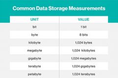
6.2: You don’t need to memorize the computermemory table, but know the difference data memory types and be able to provideexamples: int, float, double, binary. |
- Int (Integer): whole number.
- Float: decimal number, 32 bit memory size. - Double: decimal number, 64 bit memory size. - Binary: 0 or 1 (yes/no, true/false, on/off). |
|
|
6.3: Know 3-4 common raster dataset types,like elevation, and be ready to explain why that spatial variable is usuallyrepresented as a raster. |
- Land cover: thematic or discrete
- Land use: thematic - Precipitation: continuous - Temperature: continuous |
|
|
6.4: Know what raster cell resolution is.
|
Resolution must be represented by only a singular value. Options are nearest neighbor, bilinear, majority rule, and cubic convolution.
|
|
|
7.1: Some “Bad Maps” will be presented. Beable to explain why a map is bad. |
- Wrongly labeled maps. - Color schemes not relating to map message. - Color schemes rgd: color-blindness - Data message can be blurred when continuous data is categorized into unevengroups. - Map projection doesn’t support the question (e.g. research question involving area, but projection does not preservearea). |
|
|
8.1: Know the 6 essential mapping elements. |
1) title
2) author 3) date 4) projection/datum 5) north arrow 6) legend |
|
|
8.2: Have a Generalized symbol idea ready to draw, slide 12. |
|
|
|
9.1: Define "resolution." |
Unit dimensions of the pixel. |
|
|
9.2: At a broad, high level, understandand be able to state the three parts needed for linking spatial data to the Earth, slide 13. |
1) Geoid: the hypothetical shape ofthe earth, coinciding with mean sea level and its imagined extension under (orover) land areas.
2) Projection: the presentation of animage on a surface (e.g. transverse mercator). 3) Datum: a fixed starting point of ascale or operation (e.g. NAD83). |
|
|
9.3: Be able to explain why geodeticdatums are different. Know a couple example geodeticdatums and know what they are mathematically representing (e.g. sea level, gravity,etc.). |
- WGS84: Ellipsoid closely matchingthe sea surface.
- EGM2008: comprised of thegravitation forces measured across the planet. - ED50: 1950 ellipsoid to ensureEuropean nations spatially matched during WWII. Modification of the 1924International Ellipsoid (Hayford-Ellipsoid). - NAV88: North American VerticalDatum 1988. |
|
|
9.1: Define "grain." |
Smallest distance between twofeatures. |
|
|
9.1: Define "scale."
|
One to "x" relationship of apparent size or extent. |
|
|
9.1: Define "extent."
|
Maximum and minimum datum coordinates for a spatial layer.
|
|
|
9.1: Define "projection." |
Transformation of the Earth's surface onto a 2D space. |
|
|
9.1: Define "datum."
|
Set of coordinate locations specifying positions (x, y, and sometimes z).
|
|
|
10.1: Is the Earth a perfect circle? If no, what is it? |
No; oblate spheroid or oblate ellipsoid.
|
|
|
10.2: Where is the center anchor point of NAD27? NAD83? |
NAD27: "center" of US (Meades Ranch, KS).
NAD83: center of mass of earth and coordinate benchmarks conducted using satellite observations. |
|
|
10.3: What is the error difference acrossthe U.S. if you define your data incorrectly (i.e. data was collectedin NAD27, but defined in ArcMap as NAD83? |
Longitude datum shift in meters NAD83 minus NAD27.
|
|
|
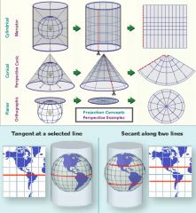
10.4: Describe the cylindrical, conic, azimuthal, tangent, and secant projection categories.
|
|
|
|
10.5: What are the five distortions a map projection is trying to preserve? Is their a projection that can preserve all five distortions? |
1) distance 2) angle 3) area 4) scale 5) shape No; there is no projection that can preserve all five distortions. |
|
|
11.1 (Coordinate Systems): Be able to explain and fill-in a diagram of the Universal Transverse Mercator (UTM) setup. Slides 10 and 11 (16 N 0666666mE 8888888mN). |
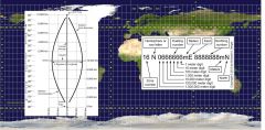
16 N 0666666mE 8888888mN - 16: zone number - First N: hemisphere or row letter - 6/8: easting/northing numbers - 0: 1,000,000m digit - last 6: 1m digit |
|
|
11.2 (Coordinate Systems): Are all state plane setups the same? Know how Oregon and 1 other state plane's setup, and be ready to provide a basic drawing. |
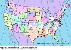
No; all state plane set ups are not the same. |
|
|
11.3 (Coordinate Systems): How is the Public Land Survey System (PLSS) laid out? Are all the PLSS blocks and sections equal? |
Starts at principal meridians. 6 mile blocks subdivided into 36 sections.
No; not all blocks and sections are equal. |
|
|
11.1 (Project Management): Be able to explain the interaction between: the spatial data itself, the computer your working on, and ArcMap.page. |
Data is stored on the computer and viewed/analyzed/processed by ArcMap.
|
|
|
11.2 (Project Management): Does the MXD file contain any ofyour spatial data? |
No. ArcMap only knows your user settings, where the data is, and how you had everything structured. |
|
|
11.3 (Project Management): If you shared your project with afriend, what would you need to provide them in order for your project to openproperly on their computer? |
.mxd file and correlating data folders.
|
|
|
11.4 (Project Management): Why is file management so importantin spatial science? |
Ease of data location, troubleshooting, and understanding (when sending to another user). |
|
|
12.1: Explain the data outcome of the Clip, Dissolve, Merge, Union, and Intersect tools. |
- Clip: Isolating data. - Dissolve: Simplifying data. - Merge: Combining data. - Union: Integrating or blending data. - Intersect: Combining data where they “intersect” spatially. (Data is of same type and structure.) |
|
|
12.2: There are two easy places to learn what any ArcTool does. Where are those two places? |
|