![]()
![]()
![]()
Use LEFT and RIGHT arrow keys to navigate between flashcards;
Use UP and DOWN arrow keys to flip the card;
H to show hint;
A reads text to speech;
65 Cards in this Set
- Front
- Back
|
Glacier |
thick ice mass that originates on land from the accumulation, compaction, and recrystallization of snow. |
|
|
Glacier Type: Alpine/Valley |
Form: High altitude Size: Smaller Shape: River |
|
|
Glacier Type: Ice Sheets |
Form: High altitudes Size: large- 10% Earth's land Greenland (1.7) and Antarctica (13.9) |
|
|
Glacier Movement: Internal |
Flowing solid Rotating grains Slipping along weak surfaces Melting and Refreezing |
|
|
Glacier Movement: External |
Basal slip- Slipping on layer of water b/w ice and bedrock |
|
|
Valley Glaciers |
Tend to accentuate the landscape
|
|
|
Valley Glaciers: Hanging Valley |
Tributary that enters a glacial trough high above the trough |
|
|
Valley Glaciers: Arete |
Narrow, knife-like ridge separating two adjacent glaciated valleys |
|
|
Valley Glaciers: Horn |
pyramid-like peak formed by glacial action in three or more cirques surrounding a mountain summit |
|
|
Valley Glaciers: Tarn |
Small lake in a cirque |
|
|
Valley Glaciers: Cirque |
amphitheater-shaped basin at the head of a glaciated valley |
|
|
Valley Glaciers: Truncated spurs |
Eroded triangular shaped cliffs in glaciated valleys |
|
|
Valley Glaciers: Glacial trough |
U-shaped glacial valley |
|
|
Ice Sheets |
tend to subdue the landscape (flatten land) |
|
|
Ice Sheets: Outwash plain |
Sand and gravels deposited by glacial melt water |
|
|
Ice Sheets: Kettle lake |
Water filled depression left by a glacial ice block |
|
|
Ice Sheets: Esker |
Ridge of sorted sand and gravel deposited in sub-glacial melt water tunels |
|
|
Ice Sheets: Drumlin |
Elongate hills formed when a glacier overrides glacial tilll |
|
|
Glacial Deposits |
Sediment deposited on land or in water as a result of glaciation |
|
|
Glacial Deposit Types: |
Till- Unsorted sediments deposited by the ice Sorted Sediments- sediments deposited by glacial melt waters |
|
|
Till- Moraines |
Pile of debris that has been transported and deposited by glacial melt water |
|
|
Till- Drumlin |
Elongates hills when a glacier overrides glacial till
|
|
|
Sorted Sediments- Outwash plain |
and and gravels deposited by glacial melt water |
|
|
Sorted Sediments- Esker |
Ridge of sorted sand and gravel deposited in sub-glacial melt water tunnels |
|
|
Ice Age Illinois |
1.8 Million years ago through 10,000 years ago |
|
|
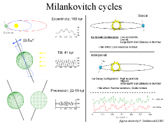
Milankovitch Cycles |
|
|
|
Ancient Atmosphere |
Methane Ammonia Water Vapor Hydrogen |
|
|
Driving forces behind change |
Ultraviolet radiation Lighting Radioactive Decay |
|
|
Atmospheric Composition |
Nitrogen 78% Oxygen 21% Argon 1% Carbon Dioxide .035% |
|
|
Atmosphere Layers by function |
Ozonosphere Ionosphere |
|
|
Atmosphere Layers by tempurature |
Troposphere Stratosphere Mesosphere Thermosphere |
|
|
Troposphere |
Lowest layer Contains 80% of the mass of the atmosphere Layer with weather Temperature decreases with height |
|
|
Stratosphere |
Occurs between 15 and 50 km Contains 18% of the mass of the atmosphere Temperature increases with height Contains ozone that shields the surface from ultraviolet radiation |
|
|
Thermosphere |
Top layer |
|
|
Global atmospheric circulation |
Ttransfer moisture to higher latitudes Hadley cell 0-30 degrees Ferrel cell 30-60 degrees Polar cell 60-90 degrees |
|
|
Green House Gases |
Water Vapor Carbon Dioxide Methane Chlo-floro-carbons (CFCs) |
|
|
Acid Rain |
Result from the chemical reaction between water and certain compounds in the atmosphere -Carbon dioxide -Sulfer oxides (SOx) -Nitrogen oxides (NOx) |
|
|
Ocean-atmosphere Links |
Exchange H2O, CO2, and heat Surface currents are driven by atmospheric circulation |
|
|
Surface Currents |
Transfer heat from one place to another Keep the upper 100 meters of the ocean well mixed Stratified |
|
|
Oceans and Climate |
Heat transferred from the Equator towards the poles |
|
|
Thermohaline Circulation |
Driven by difference in temperature and salinity Completes cycle in 6 years |
|
|
Waves |
Move energy |
|
|
Waves: Important Parts |
Waves break when wave base = 1/2 wave length Create Land forms (Barrier Islands, Sea Arches, Sea Stacks) |
|
|
Tides |
Driven by the gravitational influence of the Moon and Sun |
|
|
Deserts |
Less than 250 mm ( 10 in.) of precipitation Generally lacking vegetation Cannot support large population |
|
|
Types of Deserts |
Subtropical Continental Interior Rain shadow Coastal Desert Polar Desert |
|
|
Subtropical |
Centered around 30 degrees N and S latitude Controlled by air circulation Geographically extensive |
|
|
Continental Interior |
Far from sources of moisture |
|
|
Rain Shadow |
Mountain ranges cause barrier to flow of moisture |
|
|
Coastal Desert |
Cool dry air blows in from the ocean and evaporates occurs as it warms |
|
|
Polar Desert |
Cold air holds very little moisture What little precipitation falls remains as ice for 1000's of years |
|
|
Sediments transport by wind |
Surface creep Saltation Suspension |
|
|
Sand Dune Types |
Barchan Star Transverse Parabolic Linear Dunes |
|
|
Barchan |
Sand supply is limited, steady wind from one direction |
|
|
Star |
Wind direction varies |
|
|
Transverse |
Abundant sand, wind from one direction, form perpendicular to wind direction |
|
|
Parabolic |
Develop along shorelines from off shore winds |
|
|
Linear Dunes |
Limited sand supply, form parallel to the convergence of wind |
|
|
Dune Dependants |
Sand supply Wind velocity and variability of wind direction Surface over which the dune moves |
|
|
Deflation |
fine sands removed leaving gravel deposits |
|
|
Ventifacts |
Rocks shaped and polished by wind |
|
|
Surface Creep |
Particles too large to be lifted, move by impacts with salting sediments
|
|
|
Saltation |
Bounce along surface |
|
|
Suspension |
Small grains are carried by turbulent winds |
|
|
Loess |
Wind-blown silts and clay, derived from nearby deserts or from glacial rock flour |