![]()
![]()
![]()
Use LEFT and RIGHT arrow keys to navigate between flashcards;
Use UP and DOWN arrow keys to flip the card;
H to show hint;
A reads text to speech;
48 Cards in this Set
- Front
- Back
|
What is a drainage basin |
1) the area surrounding the river where the rain falling on the land flows into that river. This area is also called the rivers catchment 2) The boundary of a drainage basin is the watershed - any precipitation falling beyond the watershed enters a different drainage basin. 3) Drainage basins are open systems with inputs and outputs. 4) Water comes into the system as precipitation and leaves via evaporation, transpiration and river discharge. |
|
|
What is an input? |
Water coming into the system. Precipitation includes all the ways moisture comes out of the atmosphere. Precipitation is mainly rain, but don't forget other types like snow, hail, dew and frost. |
|
|
What is storage? |
Water stored in the system. 1) interception is when some precipitation lands on vegetation or other structures, like buildings and concrete or tarmac surfaces, before it reaches the soil. Interception creates significant store of water in wooded areas. Interception storage is temporary because the collected water evaporates quickly. 2) Vegetation storage is water that's been taken up by plants. It's all the water contained in plants at any one time. 3) Surface storage includes water in puddles (depression storage), ponds and lakes. 4) Groundwater storage is water stored I'm the ground, either in the soil (soil moisture) or in rocks. The water table is the top surface of the zone of saturation - the zone of soil or rock where all the pores in the soil or rock are full of water. Porous rocks (rocks with lots of holes) that hold water are called aquifers. 5) Channel storage is so obvious that it's often overlooked - it's the water held in a river or stream channel. |
|
|
Name ten flows/processes and what happens |
1) Surface runoff is water flowing over the land. It can flow over the whole surface or in little channels. It is common in arid areas where torrential rain falls on hard baked land. 2) Throughfall is water dripping from one leaf to another. 3) Stemflow is water running down a plant stem or tree trunk. 4) Through flow is water moving slowly downhill through the soil. Throughflow is faster through "pipes" - things like cracks in the soil, or animal burrows. 5) Infiltration is water soaking into the soil. Infiltration rates are influenced by soil type, soil structure and how much water's already in the soil. In a heavy storm, water can't infiltrate fast enough, so it flows over the surface. 6) Percolation is water seeping down through soil into the water table. 7) Groundwater flow is water flowing slowly below the water table through permeable rock. Water flows slowly through most rocks, but rocks that are highly permeable with lots of joints (gaps that water can get through) can have faster groundwater flow, e.g. limestone. 8) Baseflow is groundwater flow that feeds into rivers through river banks and river beds. 9) Interflow is water flowing downhill through permeable rock above the water table. 10) Channel flow is the water flowing in the river or stream it self. This is also called river's discharge. |
|
|
Name 4 outputs |
1) Evaporation is water turning into water vapour - turning from liquid to gas. 2) Transpiration is evaporation from plant leaves - plants and trees take up water through their roots and transport it to their leaves where it evaporates into the atmosphere. 3) Evapotranspiration is the process of evaporation and transpiration together. 4) River discharge, or river flow, is another output. |
|
|
Describe and explain the water balance |
Water balance is worked out from inputs and outputs. The water balance affects how much water is stored in the basin. The general water balance in the UK shows seasonal patterns: 1) In wet seasons, precipitation exceeds evapotranspiration. This creates water surplus. The ground stores fill with water so theres more surface runoff and higher discharge, so river levels rise. 2) In drier seasons, precipitation is lower than evapotranspiration. Ground stores are depleted as some water is used (plants/humans) and some flows into the river channel, but isn't replaced by precipitation. 3) So, at the end of the dry season, there's a deficit of water in the ground. The ground stores are recharged in the next wet season (I.e. autumn). |
|
|
What is river discharge affected by? |
1) Precipitation - the more precipitation, the higher the discharge. 2) Hot weather - the higher the temperature, the lower the discharge because the rate of evaporation is higher. 3) Removal of water from the river (abstraction) - also reduced the discharge. |
|
|
Name 4 characteristics of a hydrograph |
1) Peak discharge - this is the highest point on the graph, when the river discharge is at its greatest. 2) Lag time - this is the delay between peak rainfall and peak discharge. This delay happens because it takes time for the rainwater to flow into the river. A shorter lag time can increase peak discharge because more water reaches the river during a shorter period of time. 3) Rising limb - this is the part of the graph up to peak discharge. The river discharge increases as rainwater flows into the river. 4) Falling limb - this is the part of the graph after peak discharge. Discharge is decreasing because less water is flowing into the river. A shallow falling limb shows water is flowing in from stores long after it's stopped raining. |
|
|
Name 7 physical factors of a storm hydrograph |
1) Drainage basin characteristics - the physical features of the features of the drainage basin affects lag time and peak discharge. - Larger drainage basins can catch more precipitation, so they have a higher peak discharge compared to smaller basins. But smaller generally have shorter lag times because precipitation has less distance to travel, so reaches the main channel quicker. - steep-sided drainage basins have shorter lag times than shallower basins - water flows more quickly downhill into the river on steep slopes. This can also increase peak discharge. Circular basins are more likely to have a flashy hydrograph than long, narrow basins. This is because all points on the watershed are roughly the same distance from the point of discharge measurement. This means lots of water will reach the measuring point at the same time, increasing peak discharge. - basins with lots of streams (high drainage density) drain quickly, so have shorter lag times. 2) The amount of water already present in the drainage basin - affects lag time. -if the ground is already waterlogged ( the water can't absorb any more water) then infiltration is reduced and surface runoff increases. Surface runoff is much faster than through flow or base flow, so rainwater reaches the river more quickly, reducing lag time. 3) Rock type - affects lag time and peak discharge. - impermeable rocks don't store water or let water flow through them. This reduces infiltration and increases surface runoff, reducing lag time. Peak discharge also increases as more water reaches the river in a shorter period. 4) Soil type - affects lag time and peak discharge. - sandy soils allow a lot of infiltration, but clay soils have very low infiltration rates. Low infiltration rates increase surface runoff, reducing lag time and increasing peak discharge. 5) Vegetation - affects lag time and peak discharge. -vegetation intercepts precipitation and slows its movement to the river channel, increasing lag time. Interception is highest when there's lots of vegetation and deciduous trees have their leaves. -The more vegetation there is in a basin, the more water is lost (through transpiration and evaporation directly from the vegetation) before it reaches the river channel, reducing peak discharge. 6) Precipitation- affects peak discharge - intense storms will generate more precipitation and so greater peak discharges than light rain showers. - the type of precipitation also affects lag time. 7) Temperature - affects lag time and peak discharge. - hot, dry conditions and cold, freezing conditions both result in hard ground. This reduces infiltration and increases surface runoff - reducing lag time and increasing peak discharge. - high temperature can increase evapotranspiration, so less water reaches the river channel, reducing peak discharge. |
|
|
How does human activity affect the hydrograph? |
1) In urban areas, much of the soil is covered with man-made impermeable materials like concrete. Water can't infiltrate into the soil, which increases surface runoff, so water flows more quickly into the river. This makes the lag time short and increases peak discharge. 2) Man-made drainage systems affect the hydrograph in a similar way. Water flows down drains into the river before it can evaporate or infiltrate into the soil, causing a shorter lag time and increased peak discharge. |
|
|
What is headward erosion, vertical erosion and lateral erosion? |
Headward erosion makes the river longer. It happens near a river's source as through flow and surface runoff causes erosion at the point the water enters the river channel (the valley head). Vertical erosion deepens river channels. It happens in the upper stages of a river. Lateral erosion makes the river wider. It happens in the middle and lower stages of a river. |
|
|
Name five main ways in which river erosion happens |
1) Hydraulic action - the pressure of the water breaks rock particles away from the bed and banks. It's strongest in rapids and waterfalls and during floods. 2) Abrasion (corrasion) - eroded pieces of rock in the water scrape and rub against the bed and banks, removing material. Most erosion of river beds and banks happens by abrasion. 3) Attrition - eroded rocks smash into each other and break into smaller fragments. Their edges also get rounded of as they rub together. Attrition doesn't erode the bed and banks - it just makes the particles of rock in the river smaller and more rounded. 4) Cavitation - air bubbles in turbulent stretches of water implode causing shockwaves that break pieces of rick off the banks and bed. 5) Corrosion (solution) - the dissolving of rock by chemical processes. Carbon dioxide dissolves in water to form a weak acid, which reacts with rocks like limestone and chalk, breaking them down. |
|
|
Name 4 transportation processes in a river. |
1) Solution - substances that can dissolve are carried along in the water. 2) suspension - very fine material, like silt and clay particles, is whipped up by turbulence (erratic swirling of water) and carried along in the water. Most eroded material is transported this way. 3) Saltation - larger particles, like pebbles or gravel, are too heavy to be carried in suspension. Instead, the force of the water causes them to bounce along the river bed. 4) Traction - very large particles, e.g. boulders, are pushed along the river bed by the force of the water. |
|
|
How can the speed and energy of a river be reduced? |
1) Reduced rainfall causes lower discharge, which means the river slows down and has less energy. 2) Increased evaporation or abstraction (taking water out of a river for human use) also causes lower discharge. 3) Friction 4) When the river is forced to slow down like before a narrowing section of the channel. 5) A lot of energy is lost when the river meets the sea (the sea absorbs the energy). |
|
|
What is the capacity of a river? |
1) The capacity is the total land (measured in volume, weight or mass) that a river can transport at a given point. 2) The load of a river can be divided into different categories according to particles size. 3) The competence describes the maximum particle size that a river is capable of transporting at a given point. |
|
|
What are the characteristics of a hjulström curve? |
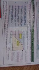
Revise picture |
|
|
What is a rivers long profile? |
1) A long profile shows you how the gradient of the river channel changes from the rivers source to its mouth by showing the height of the river bed above the base level for the whole length of the river. 2) The base level is the lowest point that the river can erode to - usually sea level ( or the level of a lake or reservoir). 3) The total amount of erosion and deposition along the full course of a river are balanced. But the rated of erosion and deposition change along the course of a river. This can result in the formation of landforms such as waterfalls (where the rate of erosion is higher than the rate of deposition), which make the profile uneven. 4) Because the total amount of erosion and deposition is balanced, the rate of erosion of landforms like waterfalls is equal to the rate of deposition elsewhere long the river. This means the over time the long profile will change from being uneven to a smooth curve. This called a graded profile (but it hardly ever happens). |
|
|
Describe the three stages a river's course is split up into. |
1) In the upper stage, the gradient is steep and the river is high above sea level, which gives it lots of potential energy (energy that can be converted into other forms). 2) As the gradient decreases towards the middle stage, potential energy is converted to kinetic energy (movement) - the river gains velocity. 3) In the lower stages, the river has littlebpotential energy, but lots of kinetic energy - it flows faster. |
|
|
What channel characteristics affect velocity and discharge? |
1) most of a river's kinetic energy is used ti overcome friction - the rest causes erosion. The more energy a river has available for erosion and transportation, the more efficient it is. An efficient river will have a high velocity, high discharge and little friction. 2) Efficiency is measured by hydraulic radius. The larger it's hydraulic radius the more efficient a river is. 3) Channel roughness also affects the efficiency. Protruding banks and large, angular boulders on the river bed increase the wetted perimeter and cause more friction. This reduces efficiency, velocity and discharge. 4) As channel roughness increases, so does turbulence (erratic swirling of water in the main flow). Turbulent flow is more effective at picking up particles from the river bed than smooth flow - so turbulence causes greater erosion. 5) Channel roughness is greatest in the upper stages of the river. So although the gradient is steep, the river loses a lot of energy to fiction, so discharge and velocity are lowest here during normal conditions. 6) In the lower stages, the banks and bed of the river are smooth, so there's much less friction. This means less energy is lost, so discharge and velocity are the highest in this stage. |
|
|
What happens in the upper, middle and lower stages of a river? |

Read each one |
|
|
Describe the shape of the cross profile at each stage of a river |
1) Upper stage valleys are steep V shapes. Vertical erosion creates narrow valley floors and steeply sloped sides. 2) Middle stage valleys are wider, caused by lateral erosion. Deposition creates a flood plain on the valley floor. 3) Lower stage valleys are wide with gently sloping sides. There's a much wider flood plain caused by deposition. |
|
|
Describe and explain the formation of a waterfall. |
1) Waterfalls form where a band of hard rock meets softer rocks. The soft rock is eroded more than the harder rock, causing a 'step' in the river bed. 2) The water flowing over the step speeds up due to the lack of friction as it drops over the step. This increase in speed gives the water greater erosive power, causing further erosion of the soft rock and undercutting of the harder rock. 3) As the hard rock is undercut, it can collapse. A deep plunge pool is carved out by abrasion at the foot of the waterfall as the bits of collapsed rock are swirled round by turbulence. 4) Over time, more undercutting causes more collapse. The waterfall will retreat (move back up the channel), leaving behind a steep-sided gorge. |
|
|
What are potholes? |
Potholes are small circular hollows in the river bed. They're formed by abrasion as turbulence swirls a river's bedload round in a circular motion, causing it to rub and scrape out holes. |
|
|
What are rapids? |
Rapids are relatively steep sections of river with turbulent flow where there are several sections of hard rock. They're a bit like mini waterfalls. |
|
|
Describe and explain the formation of meanders |
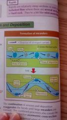
1) Meanders form where alternating pools (areas of deep water) and riffles (shallow water) develop at equally spaced intervals along a stretch of river. The distance between pools is 5-6 times the width of the river bed. 2) Because the river channel is deeper in pools it's more efficient, so it has greater energy and more erosive power. Energy is lost as the river flows over a riffle because of friction. 3) The spacing and distance between riffles and pools causes the river's flow to become uneven and maximum flow to be concentrated on one side of the river. 4) Turbulence increases in and around pools as the water speeds up, so the flow of water begins to twist and coil. 5) This causes corkskrew-like currents in the river called helicoidal flow, which spiral from bank to bank between pools. 6) The helicoidal flow causes eroded material to be deposited on the inside of the next bend, where the river loses energy. 7) The combination of erosion and deposition exaggerates the bends until large meanders are formed. The combined processes also create the meanders' distinctive asymmetrical cross-section. 8) Oxbow lakes are formed when the neck of the loop of a meander is broken through, often during flooding. Deposition dams off the loop, leaving an oxbow lake. |
|
|
What is braiding? |
1) Braiding occurs when rivers are carrying a vast amount of eroded sediment (e g in meltwater). 2) If the river's velocity drops, or the sediment river to carry, sediment is deposited in the channel. 3) This causes the river to divide into many small, winding channels that eventually rejoin to form a single channel. |
|
|
Levees |
1) Levees are natural, raised embankments formed as a river overflows its banks. 2) During a flood, material is deposited across the whole foods plain as the river loses velocity and energy due to increased friction. 3) The heaviest material (e.g. sand and gravel) is dropped first, closest to the river channel. 4) Over time, this material builds up in the river bank, creating a levee. |
|
|
What is a delta and how is it formed? |
1) When a river reaches the sea (or a lake), the energy of the river is absorbed by the slower moving water of the sea (or lake). 2) This causes the river to deposit its load. These deposits build up on the sea bed, until the alluvium (deposited sediment) rises above sea level, partially blocking the mouth of the river. 3) The river has to braid into several distributaries in order to reach the sea, forming a delta. |
|
|
What is rejuvenation? |
1) A river is said to be rejuvenated if its base level is lowered. This can be caused by either the ground level rising (crustal uplift) or by a drop in sea level. 2) The drop in base level gives the river greater potential energy, increasing its vertical erosion potential. 3) The long profile of the river is extended and a knickpoint ( a sharp change in gradient, often a waterfall) will form and mark the junction between the original long profile and the new one. |
|
|
What are the distinctive landforms associated with rejuvenation? |
1) River terraces are former flood plains which have been left above the level of present day flooding following increased vertical erosion. 2) Incised meanders are formed when a river keeps its meandering course as vertical erosion increases. The result is deep, winding valley with steep sides. The river is left far below the level of the former flood plain. |
|
|
What are the physical factors that increase the risk of flooding? |
Space vegetation or deciduous trees -space vegetation in the drainage basin means little rainfall is intercepted, so more rain reaches the ground. This increases the volume of water reaching the river, which increases discharge. -deciduous trees have no leaves in winter, which has the same effect as space vegetation - little rainfall is intercepted. Impermeable ground - Clay soils and some rocks, such as granite and shale, and impermeable - they don't allow infiltration of surface water. This increases surface runoff, which increases discharge. - If the ground has been baked hard by the heat of the summer, or it's frozen, the same thing happens - water can't infiltrate, increasing surface runoff and discharge. Circular drainage basins - water draining into the main river channel will all arrive in a short space of time because all points in the basin are a similar distance from the river. This increases discharge. High drainage density - drainage basins with a high drainage density (lots of streams) drain quickly, so have short lag times. Lots of water flows from the streams into the main river in a short space of time, increasing discharge. Steep slopes - if the drainage basin has steep-sided valley, water will reach the river channel much faster because water flows more quickly on steeper slopes. This increases discharge. |
|
|
What are the human factors that increase the risk of flooding? |
Urbanisation - Urban areas have large areas of impermeable tarmac and concrete, so when it rains surface runoff is very rapid. - Gutters and drains quickly take runoff to rivers. -Both of these things reduceblag time and so increase discharge. Flood management strategies can actually end up making flooding worse. Agriculture - Overgrazing leaves areas with less vegetation, so has the same effect as deforestation. Overgrazing and ploughing also increase soil erosion. Climatic change - Climate change could cause an increase in rainfall and more storms in some areas, which could increase flooding. Deforestation - Clearing trees and plants reduces interception and evapotranspiration. This increases the volume of water that reaches the channel, which increases discharge. - Deforestation leaves the soil loose. The soil is eroded by rainwater and carried bro the river, which raises the river bed. This reduces the channel capacity, so it takes less water for the river to flood. |
|
|
What are the social, economic and environmental impacts if flooding? |
Social 1) People and animals can be killed. 2) Flood water is often contaminated with sewage, which can lead to a lack of clean drinking water. 3) Contaminated water can also put people at risk if diseases. 4) Possessions can be damaged by floodwater or lost. 5) People can be made homeless as their properties are inundated or damaged. Economic impacts 1) Businesses often have to shut down as premises are inundated and power supplies are affected. 2) Rescue work and repairs are usually costly. Insurance premiums go up after floods. 3) Unemployment levels often rise as businesses shut down because they can't recover from the flooding. 4) Public transport, roads and bridges can be destroyed. 5) Crops can be destroyed. This can lead to a rise in the price of food. Environmental impacts 1) Floodwater contaminated with sewage and rubbish can pollute rivers. 2) Riverbanks are eroded. Positive impacts include - 1) River sediment is deposited on the flood plain. This makes the land more fertile. 2) Wetlands can be created, e.g. marshes and ponds, which are habitats for many species. |
|
|
How can flood frequency be calculated? |
1) Floods of a very large size (magnitude) don't happen very often - they're not very frequent. 2) small floods happen more often - they're more frequent. 3) large floods usually occur due to unusually heavy or prolonged rainfall. 4) By keeping records over many years, people can predict how often a flood of a certain magnitude may occur - this is called the flood return interval (RI). 5)a small flood may have an RI of one or two years, whereas a huge flood may have and RI of 100 years or more. |
|
|
Describe and explain why there's not enough money to protect everywhere from flooding. |
1) The aim of flood management is to protect homes, businesses and the environment from flooding. 2) This is because flooding can have severe social, economic and environmental impacts. 3) It's tricky trying to manage flooding though- there isn't enough money available to protect everywhere. 4) Choosing which places are protected (and how they're protected) is done using cost-benefit analysis. 5) Large settlements and important industrial sites (e.g. power plants) are more likely to be protected than small settlements or farmland. |
|
|
What ate the general disadvantages of hard engineering defences? |
1) They're expensive to build and maintain, and need technical skill. Poorer countries often can't afford these flood defences. 2) Floods happen less often, but they can be more hazardous if they do happen. E.g. if a dam breaks then a huge amount of water will rapidly flood the land. 3) Natural processes are disrupted, e.g. crops don't get fertile silt from river sediment during low-level flooding. 4) Some people think they're ugly. |
|
|
How do dams work, what are their benefits and what are their disadvantages? |
How it works -dams are huge walls built across rivers. A reservoir (artificial lake) is formed behind the dam. Flood water is caught by the dam, which prevents flooding downstream. The water is released as a steady flow throughout the year. Extra benefits -turbines are often built into dams which generate electricity. - steady water release allows irrigation of land below the dam throughout the year -people can use the reservoir for recreational activities, e.g. sailing. Disadvantages -they're very expensive. -land is flooded when a reservoir is created. This often destroys farmland and forces people to move elsewhere. -they affect wildlife, e.g. they can prevent salmon migration upstream to breeding grounds. - they can trap sediment normally carried in rivers. This can cause the dam to fail. It can also cause increased erosion downstream, as there's less protective sediment being deposited. |
|
|
How does channel straightening work, what are it's benefits and disadvantages? |
How it works -channel straightening is where meanders are removed by building artificial cut-throughs. This makes the water flow faster, which reduces flooding because water drains downstream more quickly and doesn't build up to a point where the river channel can't contain any more. Benefits It takes less time to navigate the river because it has been made shorter. Disadvantages -flooding may happen downstream instead, as flood water is carried there faster. -more erosion occurs downstream because the river flows faster. - altering river channels disturbs wildlife habitats. |
|
|
How do levees work, what are their benefits and disadvantages? |
How it works Levees are embankments built along rivers. The river can hold more water without over flowing and so it floods less often. Benefits - they allow the flood plain to be built upon. Disadvantages -they're quite expensive. -there's a risk of severe flooding if the levees are breached. |
|
|
What are the 4 main options in flood management? |
Do nothing Move people away from the hazard Modify the hazard Modify the vulnerability |
|
|
How do diversion spillways work, what are their benefits and what are their disadvantages? |
Diversion spillways are channels that take water elsewhere if the water level in the river is too high. Water is normally diverted around an important area or to another river. They prevent flooding because river discharge is reduced. The spillways often have gates that can be opened, so the release of water can be controlled. Disadvantages - an increase in discharge when the diverted water joins another river (or rejoins the same one) could cause flooding below that point. -if spillways are overwhelmed, water will flood areas not used to flooding, which could cause even bigger problems. |
|
|
How does land use management work, what are its benefits and disadvantages? |
How its works -planning restrictions prevent buildings or roads being constructed bon the flood plain. Use of the flood plains is restricted to things like playing fields, allotments or parks. More water can infiltrate so there's less surface runoff, which reduces discharge and flooding. Benefits - there are no new buildings or roads on the flood plain to be damaged, so the impact of any flooding is reduced. - it provides recreational opportunities, e.g. football fields. Disadvantages -it restricts development. This is especially a problem where there's a shortage of housing. -it can be used in areas that are already urbanised. |
|
|
How does wetland and riverbank conversation work, what are bits benefits and disadvantages? |
How it works -wetlands store flood water and also slow it down. This reduces flooding downstream. So conserving or reestablishing wetlands gives natural protection from flooding. Planting trees and shrubs along the river bank increases interception and lag time, and reduces discharge. This also decreases flooding. Benefits - vegetation protects the surface soil from erosion. - the vegetation provides habitats for wildlife. Disadvantages -lessbland is available for farming. |
|
|
How dies river restoration work, what are its benefits and disadvantages? |
How it works River restoration involves making the river more natural, e.g. by removing man-made levees. The flood plain can then flood naturally. Bad the water spreads out over the flood plain the river's discharge is reduced (because bless water is in the channel), which reduces flooding downstream. Benefits - little maintenance is needed, as the river's left in its natural state. -the river provides a better habitat for wildlife. Disadvantages -local flood risk can increase, especially if nothing's dine to prevent major flooding. |
|
|
How does alteration of urban surfaces work, what are its benefits and disadvantages? |
How it works - building porous pavements or soakways increases infiltration, which reduces rapid surface runoff to the river channel. This increases lag time, which reduces discharge and flooding. Benefits - any pollutants in the water are filtered out by the soil before the water reaches the channel Disadvantages - it's expensive |
|
|
How can the impact if flooding be reduced? |
Weather forecasts and flood warnings How it works The environment agency monitors weather forecasts, rainfall and river discharge. They warn people about possible floods through TV, radio, newspapers and internet. This mead people can evacuate before the flood happens, saving lives. People can also move possessions and use sandbags to help reduce damage if flooding occurs. Disadvantages -some people might not be able to access the communication network. -flash floods may happen too fast for warnings. -people may ignore warnings if they were inaccurate in the past. |
|
|
Why is soft engineering more sustainable than hard engineering? |
Hard engineering is often expensive and disrupts natural processes. Soft engineering tends to be cheaper and requires much less time and money to maintain than hard engineering. Soft engineering is designed to integrate with the natural environment and it creates areas like wetlands, which are important habitats for wildlife. So soft engineering is a more sustainable management strategy than hard engineering because it has lower economic cost and environmental impact. |
|
|
What is dredging? |
The removal of sediment and debris from the bottom of lakes, rivers, harbours, and other water bodies. It is routine necessity in waterways around the world because sedimentation - the natural process of sand and silt washing downstream gradually fills channels and harbours. |