![]()
![]()
![]()
Use LEFT and RIGHT arrow keys to navigate between flashcards;
Use UP and DOWN arrow keys to flip the card;
H to show hint;
A reads text to speech;
56 Cards in this Set
- Front
- Back
|
Wind Shear |
Differences in air masses that are close together |
|
|
Air Mass |
Large Body of same temperature Air |
|
|
Single Cell thunderstorm |
Minor Windshear |
|
|
Multi Cell Thunderstorm |
Medium Windshear |
|
|
Super Cell Thunderstorm |
Extreme Windshear | MesoCyclone | Rotating Updraft |
|
|
Tonados can grow up to |
500 feet in diameter |
|
|
Thunder is caused by |
Lightning causes thunder by separation of charges and then finally surges either cloud to cloud or cloud to ground. Then the air around lightning super heats and expands so fast creating a sound wave we call Thunder. |
|
|
Storm chasers would go to USA great plains because (AKA Tornado Alley) |
their is no topographic barrier in this part of the US and there is severe wind sheer (tornado Alley) |
|
|
Fujita Scale |
goes from EF 0 to EF 5 and is for measuring tornado intensity. |
|
|
Unstable Air Does What: |
warm air that rises Rises then expands Cools and Condenses Cause Clouds (Cumulonimbus/Thunderstorm) and possibly Precipitation |
|
|
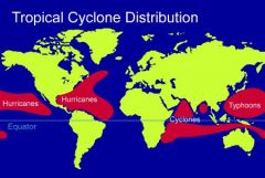
Know the locations of each different type of Super Cell Cyclone. They are all the same but we call them different things based on their location over the ocean. |
|
|
|
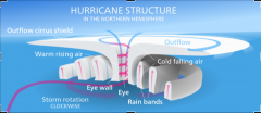
Eye of the Hurricane is calm but just around the Eye is the Eye wall where the strongest part of the hurricane.This Eye wall is surrounded by the spiral Rain Bands.As the eye passes a physical point on the ground the strong winds changes directions due to the the counter-clockwise circular motion. |
|
|
|
How Hurricanes Form |
As the pressure drops of Tropical Disturbances they turn into Tropical Depression.If the clouds of these Tropical Depressions start form together in a spiral then they can create a tropical storm40 MPH winds is the official wind speed to categorize a Tropical StormOnce a Tropical Storm forms it is categorized with intensity and given a nameOnce the Tropical Storm reaches 74 MPH it becomes a Cat 1 Hurricane |
|
|
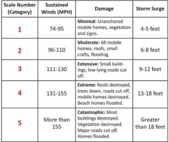
Saffir Simpson Scale Similar to the Fujita Scale the Saffir-Simpson Scale has the difference that it includes Barometric Pressure (which decreases as categories increase) and Storm Surge.Storm Surge is the change in sea level due to hurricanes. |
|
|
|
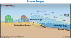
Storm Surges |
|
|
|
Conditions to stop hurricanes: |
Changes to colder temperatures Leaving the warm Body of Ocean Land Masses Atmospheric Conditions ie: wind shear will break up the hurricane causing disorganization. |
|
|
Tropical Cyclones can reach from what up to what in diameter? |
60 to 1000 Miles |
|
|
When is Hurricane Season? |
Hurricane Season June to November For example Katrina was in late August |
|
|
Year 2005 record number Hurricanes in the. |
Atlantic |
|
|
Hurricanes are associated with: |
Warm Fronts of MT Masses (high humidity) |
|
|
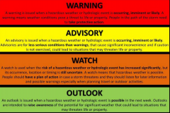
Different Levels of Weather Alerts |
|
|
|
(WMO) |
World Meteorological Organization | Geneva-based organization providing scientific voice on the state and b |
|
|
(NOAA) |
(NOAA) National Oceanic and Atmospheric Administration | Federal Agency that focuses on the condition of the oceans and atmosphere. |
|
|
(NWS) National Weather Service | Responsible for warnings and alerts |
(NWS) National Weather Service | Responsible for warnings and alerts |
|
|
Surface Weather Maps This shows weather at sea level. |
|
|
|
Station Model Diagram |
explains a lot about the weather a specific geographical location (weather station) in a concise manner.Circle shows cloud coverBar out of circle is Wind DirectionFlags off Bar are windspeed Whole Feather = 10 Knots Half Feather = 5 Knots.Symbol aside is Present Weather (rain, thunderstorm, snow, etc)Upper left is TemperatureUpper right is PressureMid left is VisibilityMid right is Pressure TrendLow left is dewpointLow right is precipitation inches past 6 hours |
|
|
El Nino |
Is the warm of the surface waters in the easter tropical Pacific Ocean |
|
|
El Nino Southern Oscillation [ENSO] |
An Irregular periodical climate change caused by variations in sea surface temperatures over the tropical easter Pacific Ocean, affecting much of the tropics and subtropics |
|
|
Teleconnections |
A causal connection or correlation between meteorological or other environmental phenomena that occur a long distance apart. This is a result of El Nino Conditions Basically the the affects of weather conditions are felt over very far distances. |
|
|
Front |
The boundary between two air masses that have different temperatures or humidity. In the mid-latitude areas of the Earth, where warm tropical air meets cooler polar air, the systems of fronts define the weather and often cause precipitation to form. |
|
|
Air Mass |
is a volume of air defined by its temperature and water vapor content. same temperature and moister over water and land will not form an air mass “m” maritime for moister and over water “c” is for continental for over land (dry) “P” poler (cold) “A” arctic very cold “T” tropical (warm) |
|
|
Land Breezes |
A breeze blowing toward the sea from the land, especially cool at night and warm during the day |
|
|
Sea Breezes |
A breeze blowing toward the land from the sea, especially cool during the day and warm at night. |
|
|
Valley Breeze |
Day Time Warm Breeze |
|
|
Mountain Breeze |
Night Time Cold Breeze |
|
|
Wind Shear |
Is a difference in wind speed or direction over a relatively short distance in the atmosphere. Atmospheric wind shear is normally described as either vertical or horizontal wind shear. |
|
|
Squall Lines |
A narrow band of high winds and storms associated with a cold front. |
|
|
Anvil Top |
Flat Top - the horizontally extended upper part of a cumulonimbus cloud |
|
|
Mesocyclone |
A cyclonic air mass associated with a supercell; its presence is a condition for a tornado warning. |
|
|
multicell thunder storms |
Multicell Cluster Storms a cluster of storms in varying stages of development. A multicell cluster consists of a group of cells moving as a single unit, with each cell in a different stage of the thunderstorm life cycle. As the multicell cluster evolves, individual cells take turns at being the most dominant. |
|
|
A mesoscale convective system (MCS) |
is a complex of thunderstorms that becomes organized on a scale larger than the individual thunderstorms but smaller than extratropical cyclones, and normally persists for several hours or more. |
|
|
Supercell thunderstorms |
are a special kind of single cell thunderstorm that can persist for many hours. They are responsible for nearly all of the significant tornadoes produced in the U.S. and for most of the hailstones larger than golf ball size. Supercell thunderstorms make super strong tornadoes |
|
|
land & Sea Breeze |
Occur at the east Coast |
|
|
Air Moves from High to Low or Low to High Pressure? |
From HIgh to Low Pressure |
|
|
Thunderstorms have stages. What are they? |
Cumulus Stage Mature Stage Dissipating Stage |
|
|
Wind Shear is Caused by
|
Interaction of Air Masses
|
|
|
Middle Part of Hurricane |
Eye of the Hurricane |
|
|
Eye Wall |
Most Intense position to be at in a hurricane which surrounds the eye. |
|
|
Spiral Main Band Does What |
Produces lots of precipitation |
|
|
Why does Antartica Not have Tornados |
Because of the Extreme Cold Air |
|
|
Wall Clouds |
Big Clouds where we can spot tornados |
|
|
Funnel Cloud |
looks like a tornado but does not touch the ground due to inappropriate environmental conditions |
|
|
Tornado System |
Cyclonic (mesocyclone) moving in counter clockwise rotation in the northern hemisphere |
|
|
Stationary Front |
Cold Air and Warm Air are meeting but not mixing together |
|
|
Occluded Front |
When Warm and Cold Air Masses Meet and mix together, Which causes Cyclones to Dissipate |
|
|
Lake Effect Snow is What |
when cold air masses pass over warm lake water that warms the lower layer of air which picks up the water vapor from the lake and rises up eventually to the cooler air above freezing it and causing snow over downwind(leeward) shores |