![]()
![]()
![]()
Use LEFT and RIGHT arrow keys to navigate between flashcards;
Use UP and DOWN arrow keys to flip the card;
H to show hint;
A reads text to speech;
37 Cards in this Set
- Front
- Back
|
Rendering of locations on the curved earth’s surface on to a flat map. |
Map Projection |
|
|
Developable Surface (3)
|
1. Cylindrical
2. Conic 3. Azimuthal |
|
|
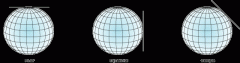
Conic Tangent is _______ |
One standard parallel (1 point touch) |
|
|
Conic Secant is _______ |
Two standard parallel (2 point touch) |
|
|
During a conic projection, the latitude line where the cone and globe meet is known as _________ |
standard parallel |
|
|
Describe the three Cylindrical aspects (developable surfaces) |
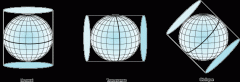
The cylinder touches globe along... 1. line of latitude (normal) 2. Line of longitude (Transverse) 3. Another line (Oblique) |
|
|
Describe the three Planar (Azimuthal ) Aspects (Developable surfaces) |
Plane is placed over a globe and can touch... 1. the pole (normal) 2. the equator (equatorial case) 3. another line (oblique) |
|
|
List the Types of Projections |
1. Conformal 2. Equivalent/equal area 3. Equidistant 4. Direction |
|
|
__________ projections preserve local shape. |
Conformal |
|
|
________ projections preserve the area of displayed features. |
Equal Area |
|
|
____________ projections preserve the distances between certain points. |
Equidistant |
|
|
What are some common projections for GIS? |
1. Geographic Projection 2. Lambert Conformal Conic 3. Transverse Mercator |
|
|
___________ is the direction of touch or intesect |
Orientation of Projection |
|
|
Coordinate systems are _________ |
A reference system used to represent the location of geographic, features, imagery, and observations such as GPS |
|
|
What are some common coordinate systems for GIS? |
1. State Plane Coordinate System 2. Universal Transverse Mercator |
|
|
What are the components of a GCS? |
1. Datum (Sphere or Ellipsoid) 2. Angular Unit of measure (DMS, DD, Radian) 3. Prime Meridian |
|
|
What are the components of a PCS? |
1. GCS (Linerage) 2. Unit of measure (meter or foot usually) 3. Map projection (specific parameters) |
|
|
Changing what is already assigned to the dataset |
Define Projection |
|
|
Creating a new dataset that is transformed to a different projection |
Project (Reprojecting) |
|
|
The science of measuring the size, shape, and gravity of the earth |
Geodesy |
|
|
________ is the most accurate representation of the earth |
Globe |
|
|
A roughly spherical shape with several undulations caused by varying strengths in gravitational pull. (mean sea level) |
Geoid |
|
|
A reference for the earth giving us the ability to determine a position (horizontal & vertical) |
Datum |
|
|
Reference surface that gives us the X, Y position for any location based on a specific ellipsoid. |
Horizontal Datum |
|
|
A zero surface from which to measure elevation |
Vertical Datum |
|
|
A ratio/proportion that tells us what distance on a map represents on the surface of the earth. |
Scale |
|
|
What are the components to good cartography |
a. Figure Ground relationship (Pop the figure out)
b. Good Visual Hierarchy (Map, Title, Legend, Background ) c. Good Balance |
|
|
a three-dimensional shape created from a two-dimensional ellipse. Oval, best representation of the earth. Sphere flattened at the poles. GPS |
Spheroid/ellipsoid |
|
|
_______ is an oval, with a major axis (the longer axis) and a minor axis (the shorter axis). |
ellipse |
|
|
Things to remember about projections (3) |
1. Need to know what to specify for projection (standard parallels, POO, Central Meridian). 2. Dataset has projection defined 3. All datasets are in same projection |
|
|
How do you represent the earth (2) |
1. Pick a reference shape and size 2. Series of reference points (shape and size + reference points = datum) |
|
|
Antipodes are _____ |
Exact opposite points on earth |
|
|
Fitted to the overall shape of the earth |
Global Datum |
|
|
Fitted to a certain region on the earth |
Local /regional Datum` |
|
|
A GCS is not a Datum. but ______` |
A datum is only one part of a GCS |
|
|
Line of latitude and longitude encompass the globe and form a gridded network called a |
graticule.
|
|
|
While a spheroid approximates the shape of the earth, a datum defines the position of the _____________ |
spheroid relative to the center of the earth.
|