![]()
![]()
![]()
Use LEFT and RIGHT arrow keys to navigate between flashcards;
Use UP and DOWN arrow keys to flip the card;
H to show hint;
A reads text to speech;
65 Cards in this Set
- Front
- Back
|
Plate techtonics |
Earth's outer shell made of individual plates that move causing earthquakes, volcanoes, mountains, formation/destruction of crust |
|
|
Pangea |
Supercontinent -- 300 million years ago continents collided |
|
|
3 types of plate movement |
Divergent, convergent, transform |
|
|
Subduction |
Oceanic plate slides under continental |
|
|
Folding |
2 plates push together and fold earth's crust to mountains |
|
|
Faulting |
Break in earth's crust from vertical plate movement |
|
|
Convection currents |
Hot currents of magma in mantle and causes plates to move |
|
|
Mantle |
Between core and crust of earth |
|
|
Earth age |
4.5 billion years |
|
|
Eras (in order) |
Precambrian, palezoic, mesozoic, canozoic |
|
|
Weathering |
Water/wind/chemicals/biotics break down existing rock |
|
|
Erosion |
Movement of weathered rock by rivers/wind/ocean |
|
|
Deposition |
Placement of eroded rock to different place (techtonic force lifts rock out of ocean) |
|
|
Weather vs climate |
Day to day vs average over time |
|
|
LOWERN? |
Latitude Ocean currents Wind Elevation Relief Near water |
|
|
Capital of manitoba |
Winnipeg |
|
|
Capital of alberta |
Edminton |
|
|
Capital of saskatewan |
Regina |
|
|
Capital of nova scotia |
Halifax |
|
|
Capital p.e.i. |
Charlottetown |
|
|
Capital new brunswick |
Fredricton |
|
|
Capital yukon |
Whitehorse |
|
|
Capital nunavut |
Iqaluit |
|
|
Capital northwest territories |
Yellowknife |
|
|
Metamorphic |
Rock formed by heat and pressure |
|
|
Leeward side |
Dry desert like side of mountain |
|
|
Permafrost |
Soil frozen all year long |
|
|
Windward side |
Side of mountain where relief precipitation occurs |
|
|
Continental drift |
Movement of land masses |
|
|
Mid Atlantic ridge |
Splitting in Atlantic Ocean |
|
|
Igneous rock |
Formed by cooling of magma |
|
|
How many plates is the earth made of? |
Approx. 30 |
|
|
Loam |
Mix of sand silt clay humus - best for growing plants |
|
|
Leeching |
Removal of minerals as water moves through soil |
|
|
Calification |
As topsoil evaporates calcium is left on surface and can be poisonous to plants |
|
|
First nations |
Native group in which members share common culture and history/wish to be treated as distinct group |
|
|
3 types of natives |
First nations, metis, inuit |
|
|
Canada's population |
35 million |
|
|
Resource |
Something used to produce good or service |
|
|
Natural resource |
Naturally created (water, wood) |
|
|
Renewable resource |
Regenerated if used carefully (plastic, fish) |
|
|
Nonrenewable resource |
Limited & can't be replaced (oil, coal) |
|
|
Flow resource |
Constantly produced, can't be damaged by humans (solar,wind) |
|
|
Mining |
Exploiting resource unsustainably |
|
|
Yield development |
Managing resource to ensure no long term depletion |
|
|
Aridity index |
Measures global water supply |
|
|
Aridity index formula |
Precipitation Ai = potential evaporation |
|
|
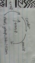
The water cycle |
|
|
|
Drainage basin |
Area of land in which all water flows to same body of water |
|
|
Our 5 main drainage basins |
Atlantic Pacific Arctic Gulf of Mexico Hudsons bay |
|
|
Population pyramid |
Shows number of people (% or #) living in country at certain age ranges |
|
|
How to colour pop pyramid |
Dependency load red, working pop green |
|
|
Pyramid types |
Expanding stationary and contracting |
|
|
Ecological footprint |
Measure of productive land an individual uses |
|
|
Demography |
The study of population |
|
|
Latitude |
Fatitude -- 90° from equator |
|
|
Longitude |
Oranges -- 180° divided by prime meridian > international date like - grenich england |
|
|
Richter scale |
Measures earthquakes |
|
|
Fog |
Warm and cold air together |
|
|
Population growth rate |
Natural increase rate + net migration rate |
|
|
Birth rate formula |
# births Total pop. ×1000 |
|
|
How does elevation effect climate? |
As air rises it expands :. It cools and reaches dew point Then we get clouds/condensation |
|
|
Geography |
Science of understanding how earth works and how people can change it |
|
|
Types of maps |
Political - countries/capitals Topographic - elevation Thematic - specific info/theme Historical - change over time |
|
|
The rock cycle |
Magma > cooled to igneous rock > heat/pressure to metamorphic/erosion to sediments > sediments compressed to sedimentary > heat/pressure to metamorphic |