![]()
![]()
![]()
Use LEFT and RIGHT arrow keys to navigate between flashcards;
Use UP and DOWN arrow keys to flip the card;
H to show hint;
A reads text to speech;
141 Cards in this Set
- Front
- Back
|
Mass Wasting |
Movement of material downslope due to gravity |
|
|
Influences on Mass Wasting (6) |
Gravity Water Soil Tectonism/Earthquakes Orientation of beds Amount of Weight |
|
|
Gravity Influences on Mass Wasting |
Gentle - gravity holds material on slope - less likely to fail Steep - gravity pulls material down slope - more likely to fail |
|
|
Angle of Repose |
Loose Material Steepest angle a material can form (general rule is, above 45 degree material will fail) Other factors change this, esp particle size Ex. Sand = 35*, Talus = 45* |
|
|
Water Influences on Mass Wasting |
Weight Lubrication Just the right amount: (damp) Surface tension Cohesion and adhesion Helps to hold material together Less likely to fail Ex. Sand - dry = mound, damp = castle, saturated = flat spread |
|
|
Soil Influence on Mass Wasting (Loose Material, Anchors) |
Loose = more likely to fall Bedrock is stronger Esp. of clays - flat/sheet-like grains slide easily Natural - roots very good at holding sediment Man-made - fence, concrete, plates and bolts, etc Problem is when you lose anchors (clear-cutting, fires) Removal of material from base of slope Nothing to support upper material More likely to fail Ex. Coasts with waves, streams, construction |
|
|
Tectonism Influences on Mass Wasting |
Shaking causes things to separate and slide Big = EQ Small = truck, vibrations, etc. |
|
|
Orientation of Beds Influences on Mass Wasting |
Bedding planes, foliation, joints, etc. Potential plane of weakness Relationship between slope and planes of weakness Slope and layers parallel = more likely to fail Slope and layers perpendicular = less likely to fail |
|
|
Weight Influence on Mass Wasting |
More weight = more gravity = more likely to fail Adding: water, houses, etc |
|
|
Three Ways Mass Wasting is Classified |
1. Type of Material 2. How It Moves 3. Velocity |
|
|
How It Moved (Three Ways) |
Flow - Moves as a viscous liquid, usually involves water Slide - move as a coherent mass (one entire unit) Fall - free-fall through air, leaves surface of earth |
|
|
How to prevent Mass Wasting from Slopes? |
Avoid over steepening during construction, use terraces If it must be steep: Retaining wall Reseed - natural anchors |
|
|
How to prevent Mass Wasting from Water? |
Get as much out as possible Drain pipes, channels Avoid loose material in rainy locations |
|
|
Hydrologic Cycle |
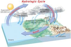
The unending circulation of Earth's water supply. The cycle is powered by energy from the sun and is characterized by continuous exchanges of water among the oceans, the atmosphere, and the continents. |
|
|
Drainage |
Starts as sheet flow, becomes increasingly more confined Streams move in confined channel |
|
|
Head vs. Mouth of Stream |
Head - start of flow usually at elevation Mouth - end point of stream - ocean, lake, body of water |
|
|
Basins vs. Divides |
Basin - A circular down folded structure Divide - An imaginary line that separates the drainage of two streams, often found along a ridge. |
|
|
Drainage Patterns (4) |
Dendritic Radial Rectangular Trellis |
|
|
Dendritic |
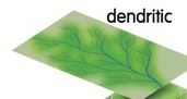
Branches like tree Most common Rocks with uniform erosion traits |
|
|
Radial |
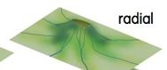
Cone-shaped mountain (volcano) Branches out like spokes on bicycle |
|
|
Rectangular |
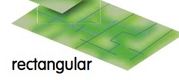
Highly fractured rocks Water moves down fractue sets --> joints Stream can turn right angles |
|
|
Trellis |
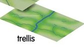
Layers of alternating hardness Main stream cuts through all, sub-stream cuts through soft |
|
|
What 3 Factors Affect the Velocity (Speed) of a Stream? |
Channel Slope Location within Channel |
|
|
Broad Channel (How Affects Speed and Sediment) |
Wide Water spreads out --> slows water More water in contact with sides and bottom Stuff (rocks, twigs, etc) on the bottom and sides will snag/slow water Usually through softer material (soft rock or sediment) |
|
|
Narrow Channel (How Affects Speed and Sediment) |
Deeper water Less contact with bottom and sides Less snags, etc Allows water to move faster Usually through harder material (hard rock) |
|
|
How Does the Location Within the Channel Effect Velocity |
Side and bottom = slower - snags, etc Middle =faster - no snags, etc |
|
|
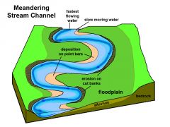
Curved vs. Straight Streams |
Curves/meanders Inside = less distance = slow water speed Outside = more distance = fast water speed Stream gets more curved over time |
|
|
Discharge |
Amount of water passing a point in a set amount of time Equals: width*depth*velocity Higher discharge = more water = faster = more energy = more erosion Any increase in a factor causes whole discharge to increase |
|
|
Base Level (Stream development) |
Physical limit of downcutting (lowest point of erosion) Ultimately this is sea level Local base level --> lake, pond, etc Streams will downcut quickly to reach this point |
|
|
Channel Head (Shape/Characteristics) |
Higher elevation/slope, V-shaped, narrow, higher velocity = more energy, more erosion and downcutting Material is rock Stream straighter --> few curves Energy is put into cutting through rock |
|
|
Channel Mouth (Shape/Characteristics) |
Lower elevation/slope, U-shaped, broader, low velocity = low energy = more deposition Sediment build up Material is sediment Stream meanders (curves) Material is easy to cut through |
|
|
Changes to Base Level (3) |
Uplift of Land/Base Level Drops Rise in Base Level Solid Base Level Constantly changing => cycle |
|
|
Uplift of Land or Base Level Drops |
Further from base level Stream want to be at base level => erosion increases and downcutting increases Can form: Near mouth prior to change => incised meanders Near head prior to change => slot canyons |
|
|
Rise in Base Level |
Sea level change or create local base level Close to base level => deposition Sediment buildup |
|
|
Constantly Changing => Cycle |
Results in stream terraces or benches |
|
|
Graded Stream |
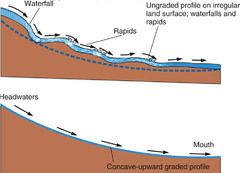
Occurs over long period of time Balance between erosion and deposition Neither is greater factor Stream is smooth over whole length With base level changes, doesn’t last long |
|
|
Large Sediment Movement (Gravel) |
Lots of energy to pick up Dropped to bottom very quickly Lots of energy to keep moving |
|
|
Medium Sediment Movement (Sand) |
Medium amount of energy to pick up Travel some distance before dropping (low energy) |
|
|
Fine Sediment Movement (Silt/Clay) |
Needs lots of energy to pick up => sticky = need to break it off of stream bottom Little energy to no energy to keep moving |
|
|
Transport of Sediment by Streams (3) |
1. In solution (Dissolved Load) 2. In suspension (Suspended Load) 3. By skipping, sliding, rolling ( Bed L |
|
|
Dissolved Load |
Material dissolves within water Salt in ocean |
|
|
Suspended Load |
Leaves bottom for extended periods of time Tiny pieces |
|
|
Bed Load |
Travels in contact with stream bottom |
|
|
Saltation |
Temporarily leaves bottom (bouncing, skipping) = medium sediment |
|
|
Types of Deposits in Streams (7) |
Regular Bars Point Bars Place Deposits Levees Flood Plains Deltas Alluvial Fans |
|
|
Regular Bars |
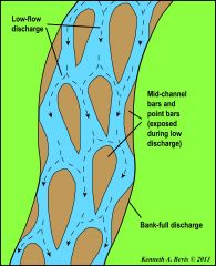
Lots of sediment in stream Water needs to flow around deposits Called braided stream |
|
|
Point Bar |

With meandering stream The inside, deposition, part of a curve |
|
|
Placer Deposit |
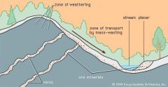
Concentrate higher density => heavy => hard to pick up => fast to drop Drop in energy = drop of material Gold, silver, metals, diamonds, rubies Near mouth, inside of cures, lots of "snags" |
|
|
Levees |
Built from flood events Large sediment will be dropped at edges of channels, the shallow area due to speed/energy drop. Will construct a pile of material Makes channel deeper by building up the edges |
|
|
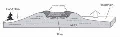
Flood Plains |
Built by floods Fine material can stay in water longer --> silt/clay Deposited in thin, horizontal layers on sides of channel |
|
|
Deltas |
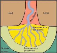
Found at mouth where reaches large body of water Stream is high energy Lake/ocean is low energy The sudden drop of energy in the stream when it reaches a large body of water will result in a deposit at the mouth Over time stream branches to move thru sediment |
|
|
Alluvial Fans |
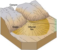
Dry/arid => desert environment Sudden drop of energy = drop of sediment Caused by a slope change Steep mountains --> high energy Flat at bottom --> low energy Fan shaped deposit Thick layer at base of mountain --> thins out into valley |
|
|
Groundwater |
Ground water in the zone of saturation Water stored in pore spaces, like sponges |
|
|
Porosity |
Empty/pore space Affected by size, shape, packing The volume of open spaces in rock or soil |
|
|
Permeability |
Connection of pore spaces Ability to move through pore spaces Flow |
|
|
How is Groundwater Replenished? |
Sinks into ground Fills up pore spaces --> goes to lowest point Forms zones |
|
|
Zones Formed by Groundwater |
Saturated zone --> deeper Every pore space filled with water Top of this layer => water table Boundary between filled with water and not Above water table (WT) --> some water water due to surface tension, etc WT: rarely level, generally follows surface topography Fluctuates |
|
|
Where Groundwater is Stored? (3) |
Aquifer Aquitard Aquiclude |
|
|
Aquifer (Define) |
Good porosity and good permeability Where water stored "fer (for)" water High porosity and permeability = better Material: sandstone, loose sediment, limestone, highly fractured rock Generally sedimentary is better (not shale) Water moves form high regions to low (gravity) |
|
|
Aquitard |
Water can move through but not very well Bad porosity or permeability or both "tardy" = late/slow, moves through but poorly on |
|
|
Aquiclude |
Water cant move through Bad porosity/permeability/or both Stops water Ex"clude"s water |
|
|
Types of Aquifers (2) |
Unconfined Confined |
|
|
Unconfined Aquifer Characteristics |
Water flows anywhere Nothing containing it Fluctuates a lot with surface conditions |
|
|
Unconfined Aquifer (Wells) |
Well: Water only rises to WT Need to pump to get it to surface |
|
|
Confined Aquifer |
Have aquitard/aquiclude (cap rock) Preventing water from moving through Holds it in one location One location of replenishment Away from here, water trapped in aquifer More water forcing in |
|
|
Confined Aquifer (Wells) |
Break through cap rock, water releases pressure build up --> rises to surface No extra energy needed Known as an artesian well |
|
|
Interactions with Surface Water |
Occurs with unconfined springs: WT Intersects surface along slope Lots of topography, cliffs, bedding, joints/fractures, foliation |
|
|
Losing Streams |
Arid/dry locations WT is low --> lower than the stream Water moves out of the stream, into the ground Stream loses water to ground Stream can dry out |
|
|
Gaining Streams |
Humid/wet regions WT is higher than stream Water moves into stream Stream gains from ground Run year round |
|
|
Interaction with Limestone (Acids) |
Naturally soluble Acid makes it more so, H2O and CO2, together makes carbonic acid => chemical weathering Speeds up process |
|
|
Caves/Caverns |
Eats away rock Occurs below WT Acid water must be in contact with rock If WT drops, in a cave/cavern, deposits can form (creation rather than destruction) |
|
|
Stalactites |
Down from Ceiling Holds "tite" to ceiling |
|
|
Stalagmites |
Grow up from Ground "mite" reach ceiling |
|
|
Sinkhole |
If ground surface above cave weakens Water cant be compressed => strong WT => filled with air => loss of strength --> collapse Human interactions make it worse Added weight, more water use |
|
|
Karst Topography |
A type of topography formed on soluble rock (especially limestone) primarily by dissolution. It is characterized by sinkholes, caves, and underground drainage. |
|
|
Hot Groundwater |
Igneous intrusions give heat |
|
|
Geysers |
Heated water Restriction --> holds water in one place Water expands as heated Continues to expand until overcomes restriction Explosively empty the chamber => geyser Chamber then refills and process starts again |
|
|
Hot Springs |
Hot water better at dissolving things than cold Water gets more concentrated in element/mineral Most common --> calcite and quartz At surface, water temperature drops Minerals deposit A spring in which the water is 6-9 C warmer than the mean annual air temperature of its locality. |
|
|
Problems with Groundwater (2) |
Depletion Pollution |
|
|
Depletion |
Withdraw exceeds replenishment Drought, overuse, etc Cant get all water out from aquifer 10-40% will stay in ground |
|
|
Cone of Depression |
High rate of withdraw from well Lowers water table around well If stop pumping, water table can recover If continues whole WT can drop |
|
|
Subsidence |
Water strengthens rock because it cannot be compressed Without water, sediment/rock can collapse within Never returns to original state Loses pore space Settling and cracking Any type of rock/sediment |
|
|
Solutions to Depletion |
Conservation Replenishment greater than depletion Greywater 99% clean water Artificial recharge - pumps back into aquifers Landscaping |
|
|
Pollution |
Lots of sources = landfills, oil spills, chemicals, etc ~25% of U.S. aquifers qualify as contaminated Pollutants stick to sediment Like purifiers Naturally filters out pollutants Slow process Pollutants behave differently - float, sink, mix |
|
|
Solutions to Pollution |
Proper property design and maintenance |
|
|
Deserts |
The driest of the dry climates Places that receive less than 10" of rain a year Can be hot or cold Water is still the main erosional force Rain in sudden bursts => flash flooding => erosion |
|
|
Locations for Deserts (3) |
Hadley Cells Rain Shadow Deserts Distance From Oceans |
|
|
Hadley Cells |
Upper atmosphere circulation At equator, air rises temps and pressure drop, air cannot hold as much water, causes precipitation At 30* north and south of equator, air descends, air and pressure rises, air tries to gain back water, causes evaporation Causes clear skies, fluffy clouds that never rain, "dry heat" At 60* north and south => precipitation At 90* north and south => deserts (cold but little rain) |
|
|
Rain Shadow Deserts |
Topography issue When precipitated clouds rise above mountains, temp and pressure drops, leaving rain On the other side of mountain, clouds fall, temp and pressure rises, evaporation Never get all water back Less and less each time goes over mountains = deserts |
|
|
Distance From Oceans |
Most precipitation starts as evaporation from ocean As moves inland, continually precipitates Some evaporate but never gets original water levels back Most rain at coasts Drier as move inland |
|
|
Desert Process |
Weathering Typically low chemical weathering (most have heat --> lack of water a greater factor) |
|
|
Rock Types for Desert Weathering |
Limestone and igneous - very resistant layers --> tend to form blocky cliffs Shale and sandstone - more easily eroded from lack of water Soft and or porous Slopes |
|
|
Desert Features (4) |
Streams Flash Floods Slot Canyons Soils |
|
|
Streams (Desert) |
Losing stream Stream only runs after major rain Then sinks into ground and stream --> dries Steams rarely meet ocean Either dry first or end at lake |
|
|
Flash Floods (Desert) |
Lots of water and erosion at one time, then none for a long time Doesn’t have to be raining near you to get flood Rain upstream --> too much water to sink into ground, flows down drainage |
|
|
Slot Canyons (Desert) |
Fast downcutting and erosion during flash floods Scour out canyons At end of canyon --> huge pile of sediment (drop in energy as canyon widens) |
|
|
Desert Landforms (6) |
Alluvial Fans Playa Lakes Mudcracks Plateaus Mesas Buttes |
|
|
Alluvial Fans (Desert) |
Deposited during flash floods Sediments: Large Angular --> round, depends on transport Biggest close --> finer as mover away Fan is thickest close --> thins as move away |
|
|
Playa Lakes (Desert) |
Water restricted to basin due to surrounding mountains Short lived chemical weathering --> dissolves salts and limes Water evaporates --> deposits salts and limes Wind bring silts and clays Ex. Death valley |
|
|
Mudcracks (Desert) |
Commonesp. with playa lakes |
|
|
Plateaus (Desert) |
High above sea level, increased downcutting, causes steep sides Top - resistant layer (limestone or igneous) Below - softer, more weatherable layer Erodes by undercutting Removes base --> top collapses Plateaus - biggest Cliffs on 1-2 sides |
|
|
Mesa |
Remnant of plateau Increased erosion Cliffs on all sides |
|
|
Butte |
Small remnant of mesa/plateau Tiny amount of resistive layer left |
|
|
Wind and Erosion |
Caused by temperature fluctuations Can be daily change of 40-50*F Only carries the smallest pieces Fine sand - carried up to 3' above ground Saltation - hops, skips, jumps, etc Silt and clay - suspended load Makes air hazy Dust storms very common |
|
|
Effects of Desert Wind/Erosion (4) |
Ventifacts Desert Pavement Desert Varnish Sand Dunes |
|
|
Ventifacts |
Rocks get smoothed and polished by natural sandblasting Erodes and shapes rocks |
|
|
Desert Pavement |
Blows all fine sediment off of the surface leaving behind larger pieces Larger pieces protests lower layers from eroding |
|
|
Desert Varnish |
Coating of oxides on outside Iron/magnesium/manganese Black on top, orange on bottom Debate on formation Silt/clay stick to outside Chemical weathering from inside rock VERY long time to form |
|
|
Sand Dunes |
Loose sand From unidirectional winds Extremely well sorted sand Blown up gentle slope falls over steep side and deposited If winds shift, cross bedding can develop |
|
|
Type of Sand Dune Depends On (5) |
Wind Direction Wind Speed Amount of Sand Vegetation Water |
|
|
Tides |
Gravitational attraction to moon and, to a lesser effect, the sun Water/fluids are more easily distorted Bulge in the water that lines up in direction of moon Stays lined up even as earth turns Hits land --> water level rises up Opposite from moon, second high tide Smaller than the first, but noticeable Caused by change from round to oval shape 2 high tides each day |
|
|
Currents (3) |
Surface Currents Upwelling El Nino |
|
|
Surface Currents |
Driven by winds |
|
|
What Effects Surface Currents |
Land locations => continents Earth's rotation Northern hemisphere => clockwise Southern hemisphere => counterclockwise Temperature Western U.S. - water starts up north => cold Eastern U.S. - water spends time at equator before travelling up => warm |
|
|
Upwelling |
Surface waters moving away from western coasts of North and South America Deep water upwells to take its place Cold water |
|
|
Upwelling and Nutrients |
Starts at bottom ocean - full of nutrients From decomposing nutrients Phospheros and nitrates => fertilizer Feeds base of food chain - algae and plankton Massive quantity of life = > huge for fishing |
|
|
El Nino |
Winds weaken --> currents weaken Lose upwelling => lose cold water and nutrients Causes increase in temperature |
|
|
El Nino Effect on Climate and Food Chain |
Causes increase in temperature Higher temps = more evaporation = more precipitation No nutrients = die off of algae, etc = die off of fish Causes collapse of food chain Occurs every 2-7 years Lasts ~ a year |
|
|
Waves |
As winds move over water, creates friction Drags water --> creates ripples If fast enough, waves develop |
|
|
Waves and Shallow Water |
Another friction Shallow water Wave motion interacts with sea floor Creates second friction Works against each other Slows down water at bottom Top stays fast Causes waves to fall over and break =>Results in white, foamy waves |
|
|
Longshore Transport |
Waves come to shore at an angle Waves hit beach at angle, and reflected straight back (not at an angle) Continually moves water, etc down coast |
|
|
Coastal Straightening |
Coasts do not start straight Wave force is concentrated on parts further into water (energy level) Caused increased erosion at those places Places further in towards shore Less energy => deposition Over time, shore line will straighten as areas erode and others fill in |
|
|
Erosion - West Coast of US |
More cliffs Little beach Full force hits base of cliff Lots of undercutting Beaches narrow and seasonal Less beach = less protection = increases erosion |
|
|
Erosion - East Coast of US |
Gentle, sloping, little topographic change Land not very high in elevation Shallower water causes wave energy to dissipate before reaching beach Keeps beaches longer - wider, and year round Highly impacted by high energy events like hurricanes --> little protection |
|
|
Barrier Islands |
Slows waves, protects beach |
|
|
Slow/Stop Erosion |
Structures Made of concrete/rocks Decrease or deflect wave energy Increases erosion elsewhere |
|
|
Slow/Stop Erosion Structure Types (4) |
Breakwater Seawall Groin Jetty |
|
|
Breakwater |
Offshore and parallel A structure that protects a near-shore area from breaking waves. |
|
|
Seawall |
Onshoreand parallel A barrier constructed to prevent waves from reaching the area behind the wall. Defend property from breaking waves |
|
|
Groin |
Perpendicular A short wall built at a right angle to the seashore to trap moving sand. |
|
|
Jetty |
Double Groin Perpendicular Pair A pair of structures extending into the ocean at the entrance to the harbor or river that are built for the purpose of protecting against storm waves and sediment deposition. |
|
|
Sand Replenishment |
Expensive Short-Lived |
|
|
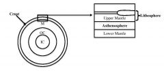
Earth's Interior |
|
|
|
Inner Core |
Mainly iron & nickel High density Temps & pressure extreme Solid |
|
|
Outer Core |
Liquid because S-waves do not travel through liquids |
|
|
Core Total |
Makes up of 1/3 Earth's Mass |
|
|
Mantle |
82% of volume of earth Usually behaves as solid Can flow at very slow rate Some partial melt |
|
|
Crust |
Solid earth; least dense material |
|
|
Lithosphere |
Upper-most rigid part of the mantle plus the crust; the lithosphere is broken up into "plates" which move around the Earth's surface dictated by plate tectonics |
|
|
Asthenosphere |
Defined as the level in the mantle below the low-velocity zone; rocks begin to melt and behave plastically (flow) at this level; only reach a semi-molten state not complete melting; this is the layer over which the plates (lithosphere) of plate tectonics slide |
|
|
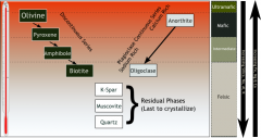
Bowen's Reaction Series |
|