![]()
![]()
![]()
Use LEFT and RIGHT arrow keys to navigate between flashcards;
Use UP and DOWN arrow keys to flip the card;
H to show hint;
A reads text to speech;
12 Cards in this Set
- Front
- Back
- 3rd side (hint)
|
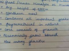
Himadri Himalyas Para |
|
Acronym: 6000NPAGSG or All 6000 Sassy Girls Go Near Pikachu |
|
|
The Northern Plains 1 |
Three rivers- deposition of alluvium in a large basin- 7 lakh square km- 2400km long- 240 to 320km wide- densely populated- soil, water, climate = agriculturally productive |
Three rivers deposited alluvium in a large basin costing 7 lakh square km 2400km×240-320km |
|
|
Northern Plains 2 |
Northern rivers= depositional work - gentle slope = decrease in velocity = formation of riverine islands → majuli in Bramhaputra = largest inhabited riverine island. |
|
|
|
Northern Plains: Tributaries of Indus |
Indus: Jhelum Chenab Ravi Satluj Beas |
Indiana Jones Can't Read Spanish Books |
|
|
Northern Plain: Punjab plain |
Western part of Northern plain- Formed by Indus & its tributaries- Larger part in Pakistan-Dominated by doabs. |
|
|
|
Northern Plains: Ganga Plains |
Extends between Ghaggar & Teesta. Flows through states of Haryana, Jharkhand(partly), West Bengal, Uttar Pradesh. |
Hermione and John Went Back to UP. |
|
|
Northern Plains: Bramphaputra |
In Assam. |
|
|
|
Peninsular Plateaus |
Tableland-Old crystalline,igneous and metamorphic rocks-formed by drifting, breaking of Gondwanaland ie. part of gondwanaland = oldest landmass-has broad & shallow valleys & rounded hills= Wearing of sharp peaks-old. |
Tuxedo Of Charles In Marriage By Dolce Gabbana Over Priced Greatly, He Rented Some Versace= Tableland; Old Crystalline Igneous Metamorphic, Breaking, Drifting of Gondwanaland, Oldest landmass, Part of Gondwanaland, Hills are Rounded & Shallow Valleys. |
|
|
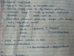
Peninsular Plateaus: Central Highlands |
|
|
|
|
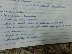
Peninsular Plateau: Deccan Plateau |
|
Tommorow Start Noting School Notes, Make Key Markings Especially, Homework Wise Separate Exercises. |
|
|
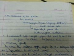
Peninsular Plateau: Deccan Plateau 2 |
|
|
|
|
Coastal Plains: Eastern Coast |
Along the Bay of Bengal- Wide and level- Northern part called Northern Circar- Southern part: Coromandel Coast- Rivers = Mahanadi, Godavari, Krishna & Kaveri→ Formed deltas- Lake Chilika= largest salt water lake in India= In Orissa, to the South of Mahanadi Delta. |
|