![]()
![]()
![]()
Use LEFT and RIGHT arrow keys to navigate between flashcards;
Use UP and DOWN arrow keys to flip the card;
H to show hint;
A reads text to speech;
95 Cards in this Set
- Front
- Back
|
The gross domestic product (GDP) |
is one the primary indicators used to gauge the health of a country's economy. It represents the total dollar value of all goods and services produced over a specific time period - you can think of it as the size of the economy.
it highly correlates with a country's energy consumption. |
|
|
Gross national product (GNP) |
is the measure of a nation’s total market value of the goods and services that are produced annually.
It in terms of per capita shows a very strong association between economic development and road infrastructure.
A paved-road investment today will result in an increased ____, about four years later. |
|
|
Infrastructure
|
“those physical facilities that are sometimes called public works” [Grigg 88]. |
|
|
Public works |
Public works are the physical structures and facilities that are developed or acquired by the public agencies to house governmental functions and provide water, power, waste disposal, transportation, and similar services to facilitate the achievement of common social and economic objectives. [Stone 74] |
|
|
Categories of Infrastructure Facilities |
Physical facilities and related services can be categorized in seven groups based on their primary functions and services: 1. Transportation 2. Water and Waste Water 3. Waste Management 4. Energy production and distribution 5. Buildings 6. Health Infrastructure Facilities 7. Recreation Facilities 8. Communication
|
|
|
Transportation |
• Ground transportation (roads, bridges, tunnels, railroads) • Air transportation (airports, heliports, ground facilities, air-traffic control) • Waterways and ports (inland waterways, shipping channels, terminals, dry docks, sea ports) • Intermodal facilities (rail/ airport terminals, truck/ rail/ port terminals) • Mass transit (subways, bus transit, light rail, monorails, platforms/ stations) • Pipelines (natural gas, crude oil)
|
|
|
Water and Wastewater |
• Water supply (pumping stations, treatment plants, main water lines, wells, mechanical/ electric equipment) • Structures (dams, diversion, levees, tunnels, aqueducts) • Agricultural water distribution (canals, rivers, weir, gates, dikes) • Sewers (main sewer lines, septic tanks, treatment plants, stormwater drains) • Stormwater drainage (roadside gutters and ditches, streams, levees)
|
|
|
Waste Management |
• Solid waste (transport, landfills, treatment plants, recycling facilities) • Hazardous waste (transport, storage facilities, treatment plants, security) • Nuclear waste (transport, storage facilities, security) |
|
|
Energy Production and Distribution |
• Fossil fuel-based electric power production (gas-, oil-, and coal-fueled power generation) • Electric power distribution grid networks (high-voltage power-transmission lines, substations, distribution systems, energy-control centers, service and maintenance facilities) • Gas pipelines (gas production, pipeline, computer stations and control centers, storage tanks, service and maintenance facilities) • Petroleum/ oil production (pumping stations, oil/ gas separation plants, roads) • Petroleum /oil distribution (marine and ground tanker terminals, pipelines, pumping stations, maintenance facilities, storage tanks) • Nuclear power stations (nuclear reactors, power-generation stations, nuclear-waste disposal facilities, emergency equipment and facilities) • Renewable energy and non-fossil fuels (infrastructure for solar power, wind power, hydro-electric power, biofuels)
|
|
|
Buildings |
• Public buildings (schools, hospitals, government offices, police stations, fire stations, postal offices, prison systems, parking structures) • Other buildings and structures— public/ residential/ commercial/ offices (public housing, structures, utilities, swimming pools, security, ground access, parking) Multipurpose and sports complexes (coliseums, amphitheaters, convention centers) • Housing facilities (public, private) • Industrial, manufacturing/ warehouse, and supply chain facilities (private) |
|
|
Health Infrastructure Facilities |
• Hospitals and public health facilities (public, private) • Veterans hospitals (public) • University teaching and research hospitals and medical centers (public, private) • Nursing homes and assisted-living facilities (private) |
|
|
Recreational Facilities |
• Parks and playgrounds (roads, parking areas, recreational facilities, office buildings, restrooms, ornamental fountains, swimming pools, picnic areas) • Lake and water sports (roads, parking areas, picnic areas, marinas) • Theme parks/ casinos (access roads, buildings, restaurants, security facilities, structures) |
|
|
Communications and Information Technology Assets |
• Telecommunications networks (land telephone/ fiber-optic line networks, telephone-exchange stations, cable distribution, power supplies, switching and data-processing centers, buildings, transmission towers, and repeat stations) • Television /cable networks (production stations, transmission facilities, cable distribution, power supplies, buildings) • Wireless/ satellite networks (satellites, ground-control centers, wireless cell towers, communication systems, receivers, buildings, services and maintenance facilities) • Information technology (IT) infrastructure and information highway networks (computer networks, cable distribution, data-processing hardware/ software, on-line and off-line cyber infrastructure including wireless and telecommunication networks, systems, information sources, buildings, backup and recording mediums, cloud computing infrastructure) |
|
|
Life Cycle Analysis (LCA) |
"is a technique to assess the environmental aspects and potential impacts associated with a product, process, or service, by: Compiling an inventory of relevant energy and material inputs and environmental releases. Evaluating the potential environmental impacts associated with identified inputs and releases" -EPA.gov |
|
|
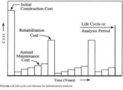
Life Cycle Cost Analysis (LCCA) |
is a tool to determine the most cost-effective option among different competing alternatives to purchase, own, operate, maintain and, finally, dispose of an object or process, when each is equally appropriate to be implemented on technical grounds.
For example, for a highway pavement, in addition to the initial construction cost, ____ takes into account all the user costs, (e.g., reduced capacity at work zones), and agency costs related to future activities, including future periodic maintenance and rehabilitation. All the costs are usually discounted and total to a present day value known as net present value (NPV). This example can be generalized on any type of material, product, or system. -Wikipedia.org |
|
|
Life-Cycle Cost Streams for infrastructure analysis |
|
|
|
Infrastructure problems have compounded over recent decades for several reasons: |
(1) the underinvestment in public works programs; (2) the lack of good management systems for infrastructure; (3) failure to recognize the importance to the future economy of maintaining a sound physical infrastructure; (4) cutbacks that have slashed public-works budgets; (5) failure to replace the infrastructure as fast as it wears out; (6) failure to realize that lack of physical infrastructure seriously impacts the level and types of services government can provide to their citizens; (7) tendency by national, state, and local officials to defer the maintenance of public infrastructure; (8) increased costs to taxpayers to repair and rebuild the obsolescent public infrastructure.
|
|
|
productivity |
is the output per unit of private capital and labor)
is positively related to government spending on infrastructure, including roads |
|
|
Framework for Infrastructure Asset Management System (IAMS) |
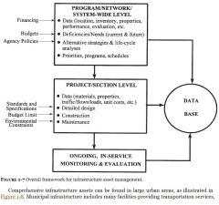
The major point of the diagram is that management can be divided into two distinct but closely integrated levels: program/ network/ system-wide and project/ section. Key elements of the overall framework for infrastructure management are ongoing, in-service monitoring and evaluation, and a database. Each of the two levels of management must consider exogenous elements over which little or no control may exist, such as financing, budgets, and agency policies for the network level, and standards and specifications, budget limits, and environmental constraints for the project level. |
|
|
Challenges of Environmental Sustainability and Funding |
Modern infrastructure asset management in the 21st century is facing the following challenges while striving for improving infrastructure condition and capacity to meet the demand: • New technologies and scientific developments and the impacts of natural and manmade disasters. • Valuation of infrastructure assets, largely in response to government accounting standards requirements, such as GASB34 in the United States (published in June 1999), PSAB3150 in Canada, and similar standards in Australia. • Quantifiable performance measures tied to realistic policy objectives and implementation targets. • Environmental stewardship and the adverse environmental impacts of deteriorating air quality, excessive noise, and lack of available mitigation strategies. • Consideration of greenhouse gas (GHG) emissions from transportation, construction, power generation, etc., and mitigation strategies. • Comprehensive approaches to sustainability including “green” infrastructure methodologies, resource conservation, reuse of materials, renewable energy, etc. • Innovative financing for publicly owned infrastructure and for Public-Private Partnerships (P3s) with emphasis on maintenance in industrialized countries and new infrastructure in developing countries. |
|
|
Asset Management |
is viewed as a framework to facilitate more informed decision-making by combining engineering and business principles
a performance-based framework to efficiently manage built facilities from a life-cycle perspective.
Asset management is the holistic assessment of a given infrastructure system using a life-cycle approach based on quality data for the purpose of optimally managing physical asset at least cost to stakeholders.
[Valencia et. al. 2011] |
|
|
Infrastructure assets |
are physical facilities that provide essential public services as required by the economic and social needs of the public
is a physical facility or an integral component of a particular physical system that is constructed and maintained to serve public needs.
can be owned and managed by either or both public agencies and private enterprises. |
|
|
system |
is a regularly interacting or interdependent group of items comprising a unified whole. |
|
|
infrastructure |
refers to a group of physical systems or facilities that provide essential public services, such as: • Transportation (mass transit, roads, airports, ports, railways, waterways, intermodal) • Utilities (water, sewer, gas, electricity) • Energy (grid network, traditional coal and other fossil-fuel power plants, hydroelectric, nuclear, geothermal, biofuel, and wind and solar renewable energy) • Telecommunications and wireless communications • Information technology and online social media • Waste disposal and landfills • Parklands, landmarks, and theme parks • Sports complexes and recreational buildings • Hospitals, public housing, rental housing, and education buildings • Industrial, manufacturing, and commercial facilities • Supply chain infrastructure assets (intermodal terminals, distribution centers)
can also include the management and human resources associated with providing a physical facility.
|
|
|
management |
is the coordination and judicious use of means and tools, such as funding and economic analysis to optimize output or accomplish a goal of infrastructure operation. |
|
|
Infrastructure asset management |
is a broad process, covering those activities involved in providing and maintaining infrastructure assets at a level of service acceptable to the public, intended users, or owners.
includes the systematic, coordinated planning and programming of investments or expenditures, design, construction, maintenance, operation, and in-service evaluation of physical infrastructures and associated facilities. |
|
|
Infrastructure Asset Management System (IAMS) framework |
consists of the operational package (methods, procedures, data, software, policies, decisions, budgets and funds, etc.) that links and enables the carrying out of all the activities involved in infrastructure asset management.
|
|
|
Ideal Infrastructure Asset Management System (IAMS) |
would coordinate and enable the execution of all activities so that optimum use is made of the funds available while maximizing the performance and preservation of infrastructure assets and provision of services.
would serve all management levels in the organization (public or private) and would be structured to be adaptable to all of its infrastructure.
In other words, it would be general in scope and incorporate particular models, methods, and procedures needed for specific types of infrastructure.
|
|
|
key points related to infrastructure decay and aging |
• The condition and level of service of infrastructure deteriorates through aging and usage. • Catastrophic failure may happen because of design and/ or construction deficiencies or overload/ impact incidents. • Some infrastructure components fail because of natural disasters, such as earthquakes and floods. • Historically, design processes have not given adequate consideration to environmental effects and their interaction with loads and material variability.
These issues indicate a need for appropriate management of infrastructure assets.
|
|
|
Lack of rational maintenance, preservation, and renovation programs is related to the following observations: |
• Generally, past design practices were geared toward producing physical systems that would last a given design life with maintenance or future preservation treatments, such as renovation, given limited consideration. • Routine maintenance was considered to be the responsibility of a maintenance group. The condition and level of service concepts suggested that facilities fail and are replaced. • “Ad-hoc” maintenance practices in response to public complaints, emergency situations, and catastrophic failures are not adequate to sustain healthy infrastructure. • Changes in use and inability to accurately predict future loads and service requirements have caused problems. • Inadequate attention has been given to performance-prediction models.
These issues indicate a need for appropriate management of infrastructure assets.
|
|
|
Sustainability |
is broadly defined as a preservation, development, and management measures that meet the needs of the present without compromising the ability of future generations to meet their own needs |
|
|
Sustainability dimensions and goals |
• Enhancing health, safety, and security • Conserving energy and enhancing the environment • Creating equitable and livable communities • Reducing costs and finding innovative financing solutions • Promoting economic prosperity
|
|
|
Planning |
involves future-related activities that are concerned with achieving desired goals.
functions are primarily concentrated at the system-wide or network level and deal with demand forecasting, site/ corridor selection, financing, budgeting, and policy issues.
3 Types Strategic , Tactical and Sustainability
|
|
|
Strategic planning |
is generally long-range and reflects financial and business aspects of planning, involving senior administration and/ or corporate managers.
|
|
|
Tactical planning |
usually reflects technical aspects of facilities and involves technical managers who are responsible for facility management and future expansion within the bounds of the strategic plans in consultation with senior administration and/ or corporate managers. |
|
|
Sustainability planning |
is related to both short-term and long-term impacts of any infrastructure planning, construction, and service phases. |
|
|
Network Management Level
|
-Sectioning, Data Acquisition, and Data Processing -Criteria for Minimum Acceptable Serviceability, Maximum Surface Distress, Minimum Structural Adequacy, etc. -Application of deterioration Prediction Models -Determination of now needs and future needs, evaluation of options and budget requirement -Identification of alternatives, Development of priority programs and schedule of work (rehabilitation, maintenance, new construction) |
|
|
Project Management Level |
-Sub-sectioning, Detailed field/Lab and other data on scheduled Projects, Data Processing -Technical (predicting deterioration) and economic analysis of within-project alternatives -Selection of best alternative; detailed quantities, Cost, Schedules -Implementation |
|
|
The scientific and engineering aspects of a systems problem span a spectrum of activities:
|
• Use of physical observation or measurements to characterize behavior • Statements of mathematical models that describe or approximate the physical phenomena • Development of a system for prescribed behavior using the mathematical models • Physical realization of the system
|
|
|
3D “Space-use” planning |
is a more accurate approach for today’s crowded urban regions |
|
|
Model development is a three-step process: |
1. Preliminary model based on historical data 2. Model verification using another set of data 3. Model calibration using alternate data collected under different conditions
Once a predictive equation is verified and calibrated, it can be used to predict the demand in a future year by entering the known or estimated values of the independent variable( s) for that year.
|
|
|
four groups that must be considered to evaluate the impact of any infrastructure development: |
(1) pollution factors (2) ecological and biodiversity factors (3) social factors (4) engineering factors.
|
|
|
Pollution factors |
Air quality, water quality, noise, construction impacts on surface and subsurface soil contamination, urban-runoff pollution, wastewater treatment, appropriate waste disposal |
|
|
Ecological and biodiversity factors: |
Wetlands, coastal zones, wildlife and waterfowl, endangered species, animal and bird habitats, flora and fauna, landscape and drainage, ecosystem disturbance
|
|
|
Sustainability factors: |
Energy consumption, carbon emissions from coal-fired electricity generation, industrial and vehicle emissions from burning of fossil fuel, other greenhouse gas (GHG) emissions |
|
|
Social factors: |
Displacement and relocation of residences and businesses, parkland and recreational areas, historical and archeological sites, cultural and religious places, natural and scenic beauty, land development, and social justice for vulnerable communities |
|
|
Engineering factors: |
Stormwater drainage, flood hazards, use of energy and natural resources, costs and benefits of alternatives |
|
|
Security |
is important considerations for planning, designing, and operating infrastructure facilities.
is needed to: (1) prevent losses caused by theft, vandalism, and arson; (2) minimize the risk of possible safety hazards to the occupants and users of the facility (3) enforce measures for complying with the applicable laws to avoid liability claims. |
|
|
life-cycle management plan |
is put into operation, preferably when the facility is opened for use.
should consider the following activities: • Rules for appropriate use of the facility • Regulations for routine/ minor maintenance to keep up with normal use and aging • Plans for emergency management of fire, accident, natural disaster (tornado, floods, earthquake, etc.), or sabotage • A program of scheduled maintenance of equipment and structures • A framework and methodology for planning condition -based and demand-responsive maintenance, rehabilitation, and renovation, as well as replacement or reconstruction (M, R& R) actions; the framework should also include analysis of “do-nothing” and deferred maintenance actions • A financial management plan to pay for the operation and life-cycle M, R& R requirements |
|
|
Service Life: |
is the period in years from the time of completion of the facility to the time when the complete facility or its components are expected to reach a state where it cannot provide acceptable service because of physical deterioration, poor performance, functional obsolescence, or unacceptably high-operating costs.
|
|
|
Performance: |
The degree to which a building or other facility serves its users and fulfills the purpose for which it was built or acquired.
In other words, is history of serviceability that shows the quality and length of service that a facility provides to its users.
|
|
|
estimate of an average service life can be made based on: |
only an estimate of an average service life can be made based on: (1) an acceptable level of performance (2) average life of the facilities in each group or similar infrastructure facilities after falling below an acceptable limit or performance or at failure.
The most important component of life-cycle analysis is the estimate of service life of a facility. |
|
|
sustainability performance indicators |
1. Service and user perception 2. Safety and sufficiency 3. Physical condition 4. Structural integrity/ load-carrying capacity 5. Sustainability related to the “triple bottom line” of environmental, social, and economic responsibility
|
|
|
decision-support system (DSS) |
refers to the use of computers to store, analyze, and display information that is used to support decision making.
more than just data-processing business as usual; it includes analysis models that generate results useful for making rational decisions.
organizes the processing, analysis, and delivery of information necessary for decision making.
is an integral component of IAMS.
|
|
|
The use of an information-support system, database management, and analytical studies can help engineers make better decisions through: |
(1) improved identification and information of the infrastructure assets; (2) access to condition data, usage, and history; (3) delineation of problem areas; (4) methodologies for needs assessment; (5) evaluation of alternative solutions; (6) projection of work programs and budgets; (7) priority setting of projects and programs of inspection and evaluation schedules. |
|
|
*The two main activities in a DSS |
are data management and study of alternatives.
These activities generate meaningful results or “knowledge” from data or “information” to support decision making.
|
|
|
Advantages of a centralized system are:
|
• Redundancy is reduced by having each piece of data stored in only one place. This also avoids inconsistencies when updating the data files. • Data can be shared for various applications. For example, frequently the data needed for pavement management is collected by different divisions within the agency. Having a centralized database ensures that all divisions will have access to the needed information. • Standards can be enforced in terms of data formats, naming, and documentation. • Security restrictions can be applied to control the flow of the data and the updating of the data. • Data integrity can be maintained by controlling the database updating and using integrity checking whenever an update is made. • Conflicting requirements of the individual users can be balanced to optimize the database for the agency. This is particularly important when sharing data between divisions. |
|
|
Temporal identification |
is accomplished by storing the data by reference of time and/ or date.
An important consideration in the development of a database-management approach |
|
|
Spatial identification |
requires being able to physically relate the data to the location of a facility in the infrastructure network. |
|
|
Spatial referencing |
is accomplished through the section-definition process, in which homogeneous sections or components with similar characteristics are identified and their physical boundaries and descriptions are established.
Geocoding (geographical-coordinate description) and the use of a Geographical Information System (GIS) can enhance this process. |
|
|
database |
refers to a large collection of data in a computer, organized in such a way that it can be expanded, updated, and retrieved rapidly for uses.
also means a specific group of data within the structure of a database-management software system. The database may be organized as a single file or as multiple files or sets. |
|
|
There are three important components for database systems: |
(1) the operating system; (2) database-management software; (3) application programs. |
|
|
GIS software |
(available for workstations and microcomputers) provides the user with mapping capabilities and links attribute databases to several map features.
is useful for the end-user to visualize the physical layout and specific attributes of an infrastructure facility.
database usually consists of two basic types of data: geographic and nongeographic.
|
|
|
Nongeographic data |
are representations of the characteristics or attributes of map features.
are stored in conventional numerical formats,
Examples include name of landmark building, parcel address, population or income attributes associated with a city or state, daily traffic volume by road, and name of a power plant. |
|
|
Geographic data |
represent map features in a computer-readable form.
use six types of graphic elements (i.e., points, lines, areas, grids, pixels, and symbols) to depict map features and annotation.
There are two groups of geographic data: vector and raster. |
|
|
Vector |
data define geometrical features by a combination of points, lines, and areas. |
|
|
Raster |
data represent the pattern of pixels that define a scanned image or a digital aerial and satellite imagery.
data is any scanned image where each location on the map directly corresponds to a location in the data storage grid.
data of scanned images require large amounts of storage memory |
|
|
five functional levels of data needs for specific agency objectives: |
Sectoral Level
Network Level
Project Level
Operational Level
Research and development
|
|
|
Sectoral Level: |
Aggregation of data from the road-infrastructure system; e.g., annual statistics and road-user charges for comparison with the education sector, for example. |
|
|
Network Level: |
Planning , programming, and budgeting: strategic planning (three to five years, medium-term needs); strategic regional-transportation planning; tactical network-level work programming for M, R& R. |
|
|
Project Level: |
Project -level programming for selection and extent of treatment and exact location; may require intensive data collection and analysis. |
|
|
Operational Level: |
Facility and operation management related to construction, maintenance, traffic, and safety. |
|
|
Research and development: |
Data needs are more detailed and precise than that for project level and operational level. Data are usually study-specific. |
|
|
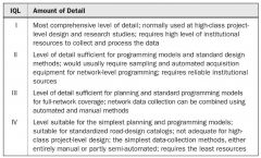
Classification of Information-Quality Level (IQL) and Detail |
|
|
|
Nishijima steps in material-property modeling |
• Catch general trend and scatter of the data. • Evaluate quality of the data set. • Deduce characteristic values of the property. • Compare the data with other data (statistical tests). • Predict values by interpolation and extrapolation. • Determine confidence limits of the property. • Obtain mathematical expressions for further tests.
|
|
|
Quality Control (QC) |
The operational techniques and activities that are used to fulfill requirements for quality. In other words, it is the process of doing and checking the work before releasing it.
is exercised through detailed step-by-step office and field procedures, instructions, and operational guidelines contained in the appropriate manuals. |
|
|
Quality Assurance (QA) |
All planned and systematic actions necessary to provide reasonable confidence that a product or service will satisfy quality requirements.
usually requires continuing verification, inspection, and evaluation of the operations and outputs. This can be accomplished for IAMS operations through on-the-job training, manual instructions, dedicated data collection, and processing forms and procedures.
|
|
|
The database for any IAMS involves the following: |
• Good identification and location-referencing data • Inventory of physical description, construction, and historical data of past actions • Condition monitoring and evaluation data • Usage data and maintenance history • Sustainability performance-measure data • Feedback system to update and improve IAMS activities
|
|
|
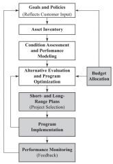
Asset Management Framework |
|
|
|
The major classes of inventory and historical data that are important to the IAMS databases: |
• Section identification and location • Functional class • Geometrical data • Structural data • Material type and property data • Appurtenance data • Construction and M, R& R history • Costs data • Environmental data • Usage history • Baseline emission data |
|
|
An inventory of infrastructure facilities |
generally refers to the data related to the physical features, including structural components, physical dimensions, material properties, and construction details (including date of original construction). |
|
|
Partitioning criteria |
should be established after a thorough study of the infrastructure network and appropriate numbering methodologies.
Examples • Agency’s jurisdiction and administrative zone boundaries • Functional and use classifications (e.g., storm sewer or sanitary sewer) • Primary construction material and geometry/ structure characteristics • Construction or major rehabilitation/ renovation/ replacement project number and completion date • Boundaries based on major operating component/ equipment locations (e.g., the junction of two sewers can be the beginning point for the first trunk sewer) • Land parcel and adjacent road references (with geographical coordinates) |
|
|
dynamic segmentation |
procedure that can be used to establish new boundaries of units without losing other physical inventory data in the original sections
can be implemented in GIS software because of its powerful query operations.
Example Even a large building, such as the Pentagon in metropolitan Washington, DC, can be subdivided into manageable units based on wing, floor, and so forth. |
|
|
A unique number for each IAMS section or management unit is important for two reasons: |
(1) the IAMS database and analysis software packages use the information to track each section; (2) the user identifies the section by its code, both in the field and on the reports generated.
The properly designed location-referencing code can be used to link numerous other infrastructure components. |
|
|
Functional class |
is an important data item for identification of IAMS sections.
reflects the geometrical and structural design standards.
Examples: The two primary functions of roads are mobility and accessibility. A functional class Commonly used functional classes are arterial (such as freeway, expressway, highway), collector, and local. |
|
|
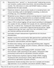
Transcription Data Collection |
from “as-built” or “as-constructed” project records. The historical project record is the least expensive source of inventory information. |
|
|
Pedestrian observer visual survey; Data Collection |
usually on a sampling basis. This is feasible for small-size facilities. It is also the best method to verify the information collected from other sources. |
|
|
Windshield surveys; Data Collection |
(moving-observer visual survey). This method is relatively faster but yields only estimates; however, it enables greater coverage for a fixed budget. • |
|
|
Photo or video logging; Data Collection |
has the advantage of permanent records. This method can be used for roads, airports,railroad tracks, subways, sewers, large waterlines, and other facilities. Subsequent data reduction by either manual or automated image-processing techniques is, however, required, but it is costly. |
|
|
Automated measurements of geometrical and structural characteristics; Data Collection |
can be done efficiently on roads, railroad tracks, and pipelines and sewers. |
|
|
Weather records; Data Collection |
can provide simple, inexpensive environmental data. |
|
|
Nondestructive testing; Data Collection |
such as ground-penetrating radar, magnetic resonance, acoustic emission, and wave-propagation methods, are sometimes useful. |
|
|
Terrestrial and kinematic laser-scanning; Data Collection |
for surface -defect mapping and three-dimensional (3D) visualization of assets at local level. |
|
|
Airborne laser scanning and digital imagery, aerial radar imaging, and spaceborne remote-sensing satellite imagery; Data Collection |
for mesoscale mapping and regional applications. |
|
|
Classifications of Inventory Data Collection Methods to Establish the Baseline History |
|