![]()
![]()
![]()
Use LEFT and RIGHT arrow keys to navigate between flashcards;
Use UP and DOWN arrow keys to flip the card;
H to show hint;
A reads text to speech;
50 Cards in this Set
- Front
- Back
|
Manually or Table digitized maps are measured in |
inches |
|
|
Digitized maps have the same measurement unit as the source map usedin digitizing T/F |
T |
|
|
Digitized maps cannot align with other GIS layers that are based on a |
projected coordinate system.Digitized map must be converted to a projected coordinate systemThe conversion is called Geometric Transformation |
|
|
Geometric Transformation also applies |
to satellite images, becauseremotely sensed data are recorded in rows and columns. |
|
|
GT can also correct errors associated with |
satellite imagery, caused by therelative motion of the satellite. |
|
|
satellite imagery, caused by therelative motion of the satellite. |
a set of control points andtransformation equations to register a digitized map, a satellite image, or an airphotograph onto a projected coordinate system |
|
|
geometric transformation includes |
map-to-map transformation (digitized maps , manual or traced) and image-to-map transformation. Georeferencing (remote sensing data) image-to image transformation |
|
|
The root mean square (RMS) error is |
a quantitative measure that can determine thequality of a geometric transformation. |
|
|
Geometric transformations are used to assign |
ground coordinates to a map ordata layer within the GIS or to adjust one data layer so it can be correctly overlayed on another of the same area. The procedure used to accomplish this correction is termed registration |
|
|
Two approaches are used in registration: |
1. the adjustment of absolute positions and2. the adjustment of relative position. |
|
|
Relative Position |
refers to the location of features in relation to a geographiccoordinate system. |
|
|
Rubber sheeting (registration by Relative Position) is |
the procedure using "slave"and "master" mathematical transformations to adjust coverage features in a nonuniformmanner. |
|
|
Absolute Position |
is the location in relation to the ground. This registration isdone by individual layers |
|
|
Map-to-Map Transformation |
Converting a newly digitized map into projectedcoordinate systemA map-to-map transformation automatically creates a newmap that is ready to use. |
|
|
Image-to-Map Transformation or Georeferencing |
Converting remotely sensed data (grid data or satellite imagery).• Transforming row and columns of a satellite image into a projected CS |
|
|
A georeferenced image can register spatially with other feature or rasterlayers in a GIS database, as long as |
the coordinate system is the same |
|
|
When you georeference your raster data, you define its location using |
mapcoordinates and assign the coordinate system of the data frame. |
|
|
Georeferencing raster data allows it to be |
viewed, queried, and analyzedwith other geographic data |
|
|
An image-to-map transformation requires an additional step of |
resampling tocomplete the transformation process |
|
|
Resampling does what |
fills in each pixel of the transformed imagewith a value derived from the original image |
|
|
Resampling |
The process of interpolating new cell values when transformingrasters to a new coordinate space or cell size |
|
|
Majority resampling |
A technique for resampling raster data in which the value ofeach cell in an output is calculated, most commonly using a 2x2 neighborhood ofthe input raster Majority resampling does not create any new cell values, so it is useful forresampling categorical or integer data, such as land use, soil, or forest type.Majority resampling acts as a type of low-pass filter for discrete data,generalizing the data and filtering out anomalous data valuesNearest neighbor resampling |
|
|
Nearest neighbor resampling |
A technique for resampling raster data in which thevalue of each cell in an output raster is calculated using the value of the nearestcell in an input raster Nearest neighbor assignment does not change any of the valuesof cells from the input layer; for this reason it is often used toresample categorical or integer data (for example, land use, soil, orforest type), or radiometric values, such as those from remotelysensed images. |
|
|
the steps for georeferencing a raster dataset are the following |
1- In ArcMap, add the raster that you want to align with your projected data. 2- Add links that connect known raster dataset positions to known positions in mapcoordinates. The Auto Registration tool can help you automatically create links. 3-Save the georeferencing information when you're satisfied with the alignment(also referred to as registration). 4-Permanently transform the raster dataset (this is optional). |
|
|
Equiarea Transformation |
allows rotation ofthe rectangle and preserves its shapeand size |
|
|
Similarity Transformation |
allows rotation ofthe rectangle and preserves its shapenot size |
|
|
Affine Transformation |
allows angulardistortion of the rectangle but preservesthe parallelism of lines The affine transformation assumes a uniformly distortedinput (map or image), and it is generally suggested formap-to-map or image-to-map transformations |
|
|
Projective Transformation |
allows bothangular and length distortions, allowing therectangle to be transformed into anirregular quadrilateral If the input is known to have a uneven distribution ofdistortion, such as an aerial photograph with reliefdisplacement (shift in the location of an object due to localtopography), then the projective transformation isrecommended |
|
|
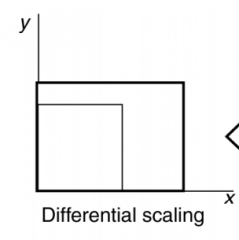
Differential scaling, |
|
|
|
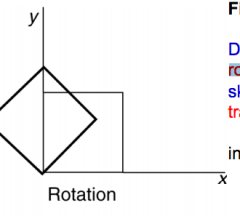
rotation |
|
|
|
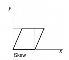
skew |
|
|
|
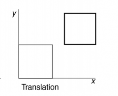
translation |
|
|
|
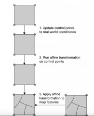
A geometric transformation typicallyinvolves three steps |
|
|
|
General Polynomial transformations |
Use surfaces generated from second- or higher order polynomial equations to transformsatellite images with high degrees of distortion and topographic relief displacement. |
|
|
The process of GPT is also called |
rubber sheeting Rubber Sheeting is a method for conflation of digital maps produced from different sourcesfor different applications |
|
|
Conflation requires solution of two generic geoprocessing problems |
Feature alignment and feature matching |
|
|
Projective and Polynomial Transformations |
For input images with uneven distribution of distortion, such an areal photograph with reliefdisplacementProjective Transformation is recommended for areal photographs. |
|
|
Satellite imagery with high degrees of distortion and topographic relief displacement, require a |
polynomial transformation that use surfaces generated from second- or higher order polynomialequations |
|
|
The process of general polynomial transformation |
“wraping” |
|
|
Projective Transformation |
A transformation used only to transform coordinates digitized directly from high-altitude aerial photographs ofrelatively flat terrain, assuming there is no systematic distortion in the photographs |
|
|
Control points play a key role in determining the accuracy of an |
affine transformation |
|
|
Control points for an image-to-map transformation, also called ground control points, are |
points where both image coordinates (in rows and columns) and real-world coordinates can beidentified GCPs are selected directly from a satellite image; the selection is not as straightforward asselecting four tics for a digitized map.Ideally, GCPS are those features that show up clearly as single distinct pixels. ( roadintersections, rock outcrops, small ponds,..) . |
|
|
Affine transformation requires a minimum of___to estimate its sixcoefficient |
3 control points |
|
|
Resampling |
process that fills each pixel of the new imagederived from an image-to-map transformation with a value or aderived value from the original image |
|
|
Three common resampling methods |
nearest neighbor, bilinear interpolation, and cubicconvolution |
|
|
The nearest neighbor resampling method |
fills each pixel of the new image with the nearest pixelvalue from the original image |
|
|
The bilinear interpolation |
uses the average of the four nearest pixel values from threelinear interpolations |
|
|
The cubic convolution method |
uses the average of the 16 nearest pixel values from five cubicpolynomial interpolations Cubic convolution tends to produce a smoother generalized output than bilinear interpolation butrequires a longer (seven times longer by some estimate) processing time |
|
|
Resampling is needed whenever there is a change of |
cell location or cell size between the input rasterand the output raster For example, projecting a raster from one coordinate system to another requires resampling to fill in thecell values of the output raster.Resampling is also involved when a raster changes from one cell size to another (e.g., from 10 to15 meters). |
|
|
Pyramiding |
a common technique for displaying large raster data sets (Box 6.5). Resampling isused with pyramiding to build different pyramid levels |