![]()
![]()
![]()
Use LEFT and RIGHT arrow keys to navigate between flashcards;
Use UP and DOWN arrow keys to flip the card;
H to show hint;
A reads text to speech;
78 Cards in this Set
- Front
- Back
|
When must you conduct a missed approach?
|
NUTS
Not visual Unable to see runway environment Tolerance Suspect aid Loss of RAIM after the IAF GNSS approach (cannot use for Mapt unless RAIM restored) GPS arrival - anytime RAIM is lost |
|
|
What clearance does the MSA give you?
|
1000' above the highest terrain.
|
|
|
When must you conduct a missed approach when on an RNAV/GNSS arrival?
|
Altitude cx
RAIM outage (AR) |
|
|
How long is a Command Instrument Rating valid for?
|
12 months commencing on the last day of the month of the test.
|
|
|
Radar operation on ground limitations?
|
Rotating - 37m
Stationary - 60m Refuel - not operating |
|
|
What are the Helicopter NVFR recency requirements?
If taking passengers? If completing a charter flight? |
NVFR:
1 x 1 flight of 1 hr 12 months 1 x T/O and landing in 6 months Passenegers: 3 x T/O and landing 90 days Charter: Twin helicopter and CIR |
|
|
List the requirements for the GPS to be used in flight as a means of navigation.
For commercial ops? |
1. Waypoints cannot be modified by crew.
2. GPS database must be current. 3. GPS instructions must be in the a/c. 4. Manually entered data must be checked by min 2 crew. 5. If single pilot: manually entered data checked against currents maps/charts. Commercial Ops: Instructions must be in flight manual. |
|
|
When can you descend below LSALT?
M A V V E C |
MSA
Approaches/Arrivals/Holds Visual Vectored Emerg Circling Area (A,B,C or D) RNP route Grid |
|
|
When are you allowed to descend below LSALT flying NVFR?
|
AD in sight and within 3nm
Radar vectored |
|
|
What are the errors of the NDB?
|
SMATCCAN
Storms Mountains Altitude Terrain Coastal Refraction Co-channel interference Angle of bank Night effect |
|
|
When can you conduct a circling approach?
C V V |
Circling area
Visual contact with landing environment Visibility = to chart min |
|
|
List the IFR procedure for an emergency change of level in CTA
|
7700
Pan x 3 Agency ID Nature Intention Position |
|
|
Radar operation on the ground distance required?
Rotating Stationary |
Rotating 37m
Stationary 60m |
|
|
IFR helicopter equipment required?
V A A C C T O A D S S |
(I)VSI
Airspeed x 2 (ice) Altimeter x 2 Compass Clock (T) Oat AI x 2 (5 inch) DG Slip x 2 Suction gauge Autopilot >5700kg = flight data recorder & windscreen wiper |
|
|
Navigation tolerance required to avoid CTA when planning an IFR flight?
|
Clear of controlled airspace, should consider requesting a clearance if operating close to the boundary.
Aircraft can operate up to the boundary when in controlled airspace. |
|
|
Minima to use when using
Area QNH TAF Actual QNH (ATIS/AWIS) If regular TAF is not available Does a METAR meet the requirement for a QNH source? |
Area QNH - add 50'
TAF - Printed minima Actual QNH (ATIS/AWIS) - minus 100' Regular TAF not available - add 50' A METAR does not meet the requirement |
|
|
If there is normally no regular TAF for an aerodrome, do you need to adjust the minima?
|
No, it is already taken into account on the plate.
|
|
|
Recent experience requirements IFR
|
Within 90 days IMC or under hood
Command Dual Synth Trainer |
|
|
Recent experience requirements NVFR
|
1 T/O & land in 6 month
|
|
|
What does RAIM stand for?
|
Reciever Autonomous Integrity Monitoring
|
|
|
When do you need to notify ATC if RAIM is lost?
|
ENR 1.1 - 46 3.3.11.2 2. RAIM not avail when ATC requests GPS distance 3. GPS in DR mode or loss of NAV function > 1 min 4. Indicated displacement from TRK > 2nm |
|
|
What is the definition of visual reference with the runway environment?
|
runway threshold, or
approach lights or other markings identifiable with the landing runway clearly visible to the pilot |
|
|
What is the required splay for LSALT calculations?
|
AIP ENR 3.3 - 20 DR - 15 deg to 50nm + 5nm buffer RNP 2 - 5nm sausage RNP 4 - 15 deg to 8nm + 5nm buffer RNAV with GNSS - 15 deg to 7nm + 5nm buffer Non GNSS - 15 deg to 30nm + 5nm buffer |
|
|
Can the area QNH be used for an altimeter test?
Can the forecast QNH be used for an altimeter test? |
No. Only ATIS or AWIS
and...no. |
|
|
What are the errors of the VOR?
|
AVGAS
Airborne equipment error Vertical polarisation Ground station error Aggregate Site effect |
|
|
What are the recency requirements in order to conduct the following approaches?
2D 3D Azimuth |
Last 90 days 3 instrument approaches including one in the aircraft.
2D - 90 days 3D - 90 days Azimuth - 90 days |
|
|
What are the recent requirements for conducting an RNAV/GNSS approach?
|
Preceding 6 months has completed RNAV/GNSS app (flight or approved sim) and GNSS is the same as fitted in the aircraft (or approved by CASA).
|
|
|
What other approach will satisfy the recency requirements of a GPS arrival?
|
DME arrival
|
|
|
What are the requirements to be able to fly as single pilot in IMC?
|
Flown within 90 days 1 hour a/c on approved single engine a/c or sim
or passed test plus one approach (not arrival) |
|
|
What is the requirement for one of the radio's required?
|
Capable of continuous comms with ATS on all stages of flight.
|
|
|
Radio failure in controlled airspace?
Radar vectored? Holding? |
Squawk 7600
1.Maintain last assigned level 3 minutes. Proceed with last clearance. 2. Being radar vectored - maintain last vector 2 minutes. Proceed with last clearance. 3. Holding - complete one more hold. Proceed with last clearance. |
|
|
Can the area forecast be used for an altimeter test?
|
No. ATIS, AWIS or tower is OK though.
|
|
|
If given a change of level when must it be completed?
|
ASAP but no later than 1 min (unless specified a later time).
|
|
|
What are the requirements when conducting a GPS arrival?
|
Current database
Coords must not be capable of modification RAIM must be available before descent below MSA/LSALT Azimuth must be provided by NDB/VOR Missed approach if disparity between NDB/VOR track and GPS track of NDB - 7deg VOR 5.5 deg |
|
|
What are the navigation requirements when under IFR?
|
GNSS or GPS is used
After making track allowance of 9 deg from last positive fix, come into rated coverage of aid. (6.67 x rated coverage of aid). Positive fixes <2hrs |
|
|
If suitable enroute navigation systems are not available, how can you navigate IFR?
|
Weather is VMC
Navigate by visual ref to ground/water Able to positively fix <30min |
|
|
What constitutes a position fix?
|
Passage over an aid
GNSS Intersection of two or more lines at angles not less than 45 deg Position lines within the rated coverage of the aid |
|
|
If a position fix is obtained soley by 2 NDB's, what are the requirements?
|
Must be within 30 nm of each NDB
|
|
|
What is the alternate minima for helicopters operating at night?
|
Ceiling 1500'
Vis 8km |
|
|
What are the alternate requirements for navigation aids for RPT and CHTR?
|
One aid on ground, two in air
2 aids on ground, two in air |
|
|
What are the alternate requirements for navigation aids for air work and private ops?
|
One up and one down.
|
|
|
Do you need to always provide an alternate if the destination aerodrome does not have an aid?
|
No, provided that:
Final route segment = No greater than SCT below LSALT + 500' vis >8km |
|
|
Limits for RAIM |
2.0nm for En-route 1.0nm for terminal 0.3nm for 2D approach |
|
|
What constitutes a position fix? |
Intersection of NDB or VOR within rated coverage 2 NDB's within 30nm GNSS constant fix Passage over the aid |
|
|
Time/distance between positive fixes? |
6.39 x the rated coverage of the aid with 9 deg track error 2 hours maximum between fixes |
|
|
LSALT area for RNP 2 |
5nm either side of track |
|
|
If the destination aerodrome has no aid (no TAF) an alternate is required unless? |
By day + GAF = no more than SCT below LSALT + 500ft VIS > 8km |
|
|
When can the special alternate minima be used on a DAP? |
Only if the aircraft is fitted with two independent ILS receivers. The METAR/SPECI service must be available and the tower open. |
|
|
New NVIS vertical and horizontal distance from cloud in VMC in class C? |
clear of cloud |
|
|
NVIS in flight cloud/vis requirements |
IFR capable aircraft = NVFR or below LSALT IFR = No more than SCT up to 1000 AGL within 2nm either side of track (4nm sausage) NVFR capable aircraft = No more than SCT up to 2000 AGL within 2nm either side of track (4nm sausage) |
|
|
What is the new in-flight visibility minima for NVIS operations? |
3000m in any class of airspace- must be approved by CASA |
|
|
At what point on the RNAV should you conduct a missed approach with RAIM outage? |
Anytime after the IAF |
|
|
Can class B NVIS be used with both A or B cockpit? |
Yes |
|
|
Can a 2 pilot NVIS crew land at a standard or basic HLS without the need of an alternate? |
A 2 qualified NVIS crew Operation (2 pilots or a pilot and an aircrew member) can plan to land at either an HLS NVIS standard or basic with no alternate HLS lighting requirement, provided the requirements of the operator's risk management plan are met. Single pilot - yes |
|
|
For a TAF3, do the 30min alternate buffers need to be applied? |
Not within the first 3 hours of the TAF3 validity. Outside of this - yes. |
|
|
Do you need to provide for an alternate in the first 3 hours of a TAF3? |
AIP ENR 1.1para 10.7.2.9 - if you are planning using a TAF3 within the first 3 hours, you can ignore any requirement for alternate fuel. |
|
|
Do you need to carry variable reserve on alternate fuel requirements? |
No - only the destination flight fuel requires a variable reserve. |
|
|
Max speed in approach CAT A? |
100KIAS |
|
|
What clearance does a missed approach give you? |
A minimum of 100 FT obstacle clearance at 2.5% |
|
|
OCTA departure report to ATS |
Dept time. Outbound track Intended cruising level. Estimate for the first en-route reporting point. |
|
|
Class C departure report |
Direction of turn, Initial radar heading, Current altitude to the nearest 100 feet Last assigned level. |
|
|
Rate of climb required in a SID |
Multiply gradient x GS |
|
|
If OEI after entering IMC and your plan is to return to the aerodrome - take off minima must be equal to landing minima. |
o |
|
|
When operating in a radar environment and you are identified, do you need to provide position reports? |
No |
|
|
Are you required to compensate for wind when conducting a SID? |
A pilot will not need to compensate for known wind effects when being radar vectored but will compensate whenflying routes which are expressed as tracks |
|
|
The meteorological requirements for a pilot to request visual departure for an IFR flight in a control zone are? |
cloud base must be above the MSA or LSALT for the particular route. (AIP ENR 1.1 para 2.5) |
|
|
A sector is determined by the aircrafts heading or track? |
Heading |
|
|
Is wind to be allowed for in the hold for timing and track? |
Yes |
|
|
When must a missed approach be carried out during a GNSS or DME arrival? |
Anytime a RAIM warning appears |
|
|
What is the DME ARC tolerance and when must the arc be joined? |
2nm and before the Initial Approach Fix |
|
|
Texas hospital has no approach plate. What are the requirements in order to plan IFR to this HLS? |
GAF only is required for weather. By day, can be planned without an alternate provided no more than SCT below LSALT + 500' and 8km vis. By night there is no aid so need an alternate. (could plan to use NVIS below LSALT to keep clear of cloud with 5km vis within 2nm either side of track up to 1000 AGL - but still require alternate due to being an IFR plan?????) |
|
|
What is the expectation when conducting a missed approach during visual circling? |
climbing turn towards the runway establish climbing on the missed approach track |
|
|
Is there a level segment on an ILS approach? |
No. Once the DA is reached a decision is made to either land or conduct the missed approach. There is no level segment. |
|
|
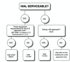
HIAL requirements |
|
|
|
Can you manoeuvre in the sector after the FAF during a GNSS arrival? |
No. Manoeuvring is allowed within the sector before the FAF. |
|
|
Takeoff minima for multi engine helicopter |
Clear of cloud 800m (550m if 60m runway lights, centreline lights & secondary power) |
|
|
VV010 represents what in a TAF? |
Vertical Visibility of 1000' in lieu of cloud base. VV height is equivalent to an OVC cloud layer at the same height. |
|
|
Explain TAF3 for the first 3 hours |
No buffers for FM or BCMG Prob for TS and turbulence ignored Prob reducing VIS below alt min ignored |