![]()
![]()
![]()
Use LEFT and RIGHT arrow keys to navigate between flashcards;
Use UP and DOWN arrow keys to flip the card;
H to show hint;
A reads text to speech;
8 Cards in this Set
- Front
- Back
|
Geoglyphs |
Drawing on the Earth's surface |
|
|
Trapezoid |
The Nasca Lines were made over a period of several centuries simply by selectively removing dark stones to reveal the light ones below. (Early Intermediate Period) |
|
|
Ayllus |
The traditional form of a community in the Andes, especially among Quechuas and Aymaras. They are an indigenous local government model across the Andes region of South America, particularly in Bolivia and Peru. |
|
|
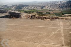
Aerial view of plains with trapezoids (pg. 89) c. 400 BCE - 600 CE
|
|
|
|
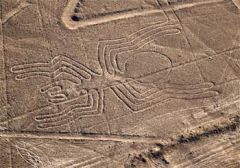
“Spider” figure (pg. 88) 400 BCE - 600 CE Audience = the gods; never intended to be looked at by humans (we lose sight of that - theory that aliens did it is arrogant)
In danger of being destroyed - "sweeping" = cleaning up the lines so they they're more visible in order to bring in more tourists but it ruins them (authenticity and value are destroyed)
Located in a dry valley positioned in between the Andean Mts. and the coast - in the foothills of a giant "funnel" Water = significant resource in the area, underground and rainfall - rain runs down the mountains and gets absorbed into the soil --> varying extreme elements of wet and dry
Earth is compressed where these geoglyphs are showing evidence that people walked through them
These lines were created for religious purposes, indication of being walked on, pottery smashed next the them - spondylus shells appear on the coast in El Niño events that bring rain; these shells are a symbol of water and fertility Ceramic vessels were purposely smashed as an offering or sacrifice, releasing its energy into the world
|
|
|
|
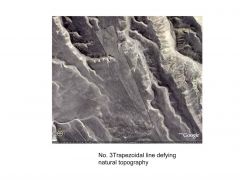
Trapezoidal line defying natural topography 400 BCE - 600 CE |
|
|
|
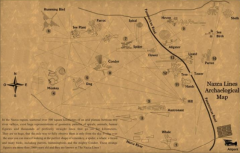
Map with Nasca lines (pg. 87) 400 BCE - 600CE
200 sq. miles of 100's of lines, trapezoidal, rays & 30 giants figures of animals and plants Images mirror those found on Nasca pottery and they found objects
21st century Peruvians still use the lines as a ritual pilgrimage |
|
|
|
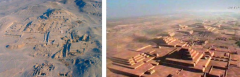
Aerial view and reconstruction of Nasca ceremonial center, Cahuachi 400 BCE - 600 CE
Located near Nasca lines that were built before this site The lines from the earthworks direct you towards the site
This is not a city but a place people would temporarily come for a spiritual experience (like Chavin)
About 40 temples and at least 500 tombs have been found
Presence of rare water made it a sacred place
Textiles: borders, fringe = represents decapitated heads
El Niño = originates off the coast of Peru; changes water and air currents which drastically changes weather patterns --> excessive rain or drought --> everything at Cahuachi dried up everything so they built enormous wells in the shape of spirals |
|