![]()
![]()
![]()
Use LEFT and RIGHT arrow keys to navigate between flashcards;
Use UP and DOWN arrow keys to flip the card;
H to show hint;
A reads text to speech;
35 Cards in this Set
- Front
- Back
|
list the 3 types of map projections |
|
|
|
cylindrical projections |
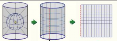
Mercator |
|
|
conical projections |
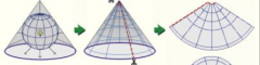
perspective conic |
|
|
planar projections |
orthographic |
|
|
which type of projection is good for the poles? |
planar/orthographic |
|
|
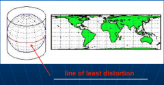
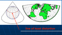
where is the line of least distortion on a cylinder projection? |
|
|
|
where are the lines of least distortion on normal, transverse, and oblique cylindrical projections? |

|
|
|
where is the line of least distortion on a conic projection? |
|
|
|
where is the line of least distortion on a planar projection? |

|
|
|
"all maps lie flat and ______________" - _______________ |
"all maps lie flat and all flat maps lie" - Mark Monmonier |
|
|
all projections have.... |
some distortion |
|
|
specific projections minimize distortion in one or more of the following areas... |
|
|
|
[ specific projections minimize distortion in one or more of the following areas... ] area |
equivalent or equal area
|
|
|
[ specific projections minimize distortion in one or more of the following areas... ] distance |
equidistant or true distance |
|
|
[ specific projections minimize distortion in one or more of the following areas... ] direction |
azimuthal or true direction
|
|
|
[ specific projections minimize distortion in one or more of the following areas... ] shape |
conformal or true shape |
|
|
[ map distortion examples ] unprojected |
UTM if you unrolled latitude and longitude grid and spread it out...just a flat way of looking at the globe |
|
|
[ map distortion examples ] Mercator |
based on same principals of unprojected... |
|
|
what are the 2 most important projections to know? |
|
|
|
Lambert conformal conic and transverse Mercator are both ____________ |
conformal projections (preserve shape) |
|
|
Lambert conformal conic |
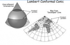
distances true only along the standard meridian or standard parallels |
|
|
transverse Mercator |
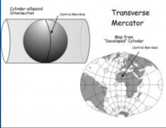
distortion of distance, area, and direction increase with distance from the central meridian or standard parallels |
|
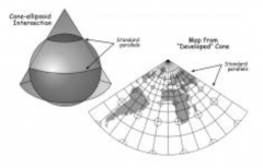
which type of projection is this? |
Lambert conformal conic |
|
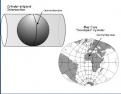
which type of projection is this? |
transverse Mercator |
|
|
what is a coordinate system? |
2-dimensional model of the earth's surface |
|
|
what 4 things are coordinate systems defined by? |
|
|
|
common coordinate systems |
|
|
|
how many UTM zones are there? |
60 |
|
|
UTM is much more common for... |
state and smaller things |
|
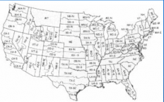
which coordinate system is this? |
state plane |
|
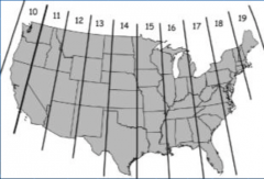
which coordinate system is this? |
UTM |
|
|
[ Georgia State Plane ] Georgia Coordinate System |
|
|
|
[ Georgia State Plane ] Georgia Coordinate System of 1985 |
|
|
|
[ practical applications ] select a coordinate system with ____________ for your project area |
the least distortion |
|
|
[ practical applications ] make sure _________ and _________ (on a given project) are using the same _______________ |
make sure all data and all people (on a given project) are using the same coordinate system |